South Texas From Laredo to Brownsville Faces Significant Flash Flood Threat as Some Spots Could Top 6 to 12 Inches of Rain by Monday Evening
LAREDO, TEXAS — The flood threat is ramping up across South Texas this weekend, with significant flash flooding possible as some areas could pick up more than 6 inches of rain by Monday evening, November 9, 2026.
A low-pressure system moving through Mexico is pulling in deep Gulf of Mexico moisture, setting the stage for heavy, repeated downpours.
What’s Driving the Heavy Rain
The setup is simple but powerful:
- A low moving across northern Mexico
- Moist air streaming in from the Gulf
- Storms repeating over the same areas
Together, these factors could produce extreme rainfall totals in parts of South Texas.
Two Forecasts, Two Possible Bullseyes
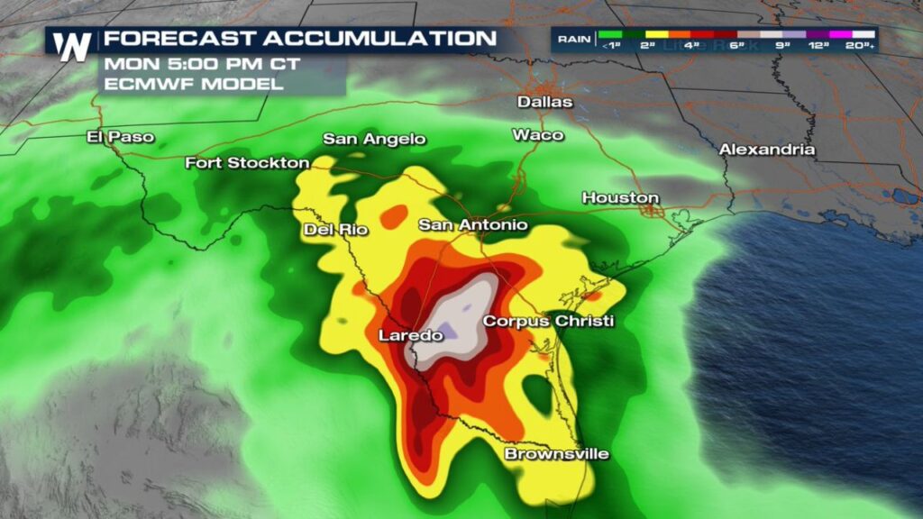
Forecast models agree on very heavy rain, but differ on where the heaviest totals will fall through 5 p.m. CT Monday.
| Area | Forecast One | Forecast Two |
|---|---|---|
| Near and northeast of Laredo | About 4 to 6 inches | About 9 to 12+ inches |
| Deep South Texas between Corpus Christi and Brownsville | About 6 to 12+ inches | About 2 to 4 inches |
| Southwest of San Antonio toward Del Rio | About 4 to 9 inches | About 2 to 4 inches |
| Brownsville | About 4 to 6 inches | About 2 to 3 inches |
| Corpus Christi | About 2 to 4 inches | About 2 to 4 inches |
| San Antonio | About 2 to 4 inches | About 2 to 3 inches |
| Houston | Under 1 inch | Under 1 inch |
| Dallas and Waco | Under 1 inch | Under 1 inch |
Forecast One: Heaviest Rain Near the Lower Rio Grande Valley
One forecast places the highest totals, up to 12 inches or more, across Deep South Texas between Corpus Christi and Brownsville, with another area of heavy rain southwest of San Antonio toward Del Rio.
Forecast Two: Bullseye Near Laredo
The other forecast focuses the heaviest rain near and northeast of Laredo, where totals could reach 9 to 12+ inches, with 6 to 9 inches surrounding that core.
Why Flash Flooding Is a Big Concern
Rain totals this high can quickly cause:
- Flooded low-water crossings and roads
- Rising creeks, rivers and arroyos
- Urban flooding in Laredo, McAllen, Harlingen and Brownsville
- Water entering homes in low-lying neighborhoods
Welcome Rain, but Too Much at Once
Much of South Texas has been in drought, so rain is needed. But when 6 to 12 inches falls in a short time, the ground cannot absorb it fast enough, leading to runoff and flooding.
Areas Farther North Get Lighter Totals
Places like Houston, Dallas, Waco and San Angelo are expected to see much lighter rain, generally under 1 to 2 inches.
Part of a Wet Weekend Across Texas
This latest forecast builds on earlier outlooks calling for 3 to 5 inches across central and southern Texas, with scattered flash flooding possible. Newer guidance now points to even higher totals in parts of South Texas.
Flood Safety Reminders
- Turn around, don’t drown at flooded roads
- Never drive through moving water
- Avoid travel at night during heavy rain
- Move to higher ground if water rises
- Keep phone alerts on for flash flood warnings
Outlook: Heavy Rain Through Monday
The heaviest rain is expected through Monday afternoon, with drier weather returning later in the week.
Stay with Bchssreport.com for the latest updates on this story.
About The Author
