Mid-Atlantic and Northeast Watch Possible Coastal Storm Next Weekend That Could Bring Rain, Mountain Snow and Gusty Coastal Winds, but Track Remains Uncertain
MID-ATLANTIC — A developing low-pressure system could bring mixed precipitation to the Mid-Atlantic and Northeast by next weekend, according to the National Weather Service’s Weather Prediction Center. Forecasters say a storm is likely to form, but there is still a lot of uncertainty about who will see what.
Storm Timeline
| Time | What’s Expected |
|---|---|
| Late Wednesday, November 11 | Low pressure develops across the Ohio Valley |
| Thursday, November 12 | System tracks east |
| Friday, November 13 | Low moves off the Mid-Atlantic coast and strengthens |
| Friday through next weekend | Much cooler than normal temperatures |
What Forecasters Know
The Weather Prediction Center outlined several things forecasters are fairly confident about:
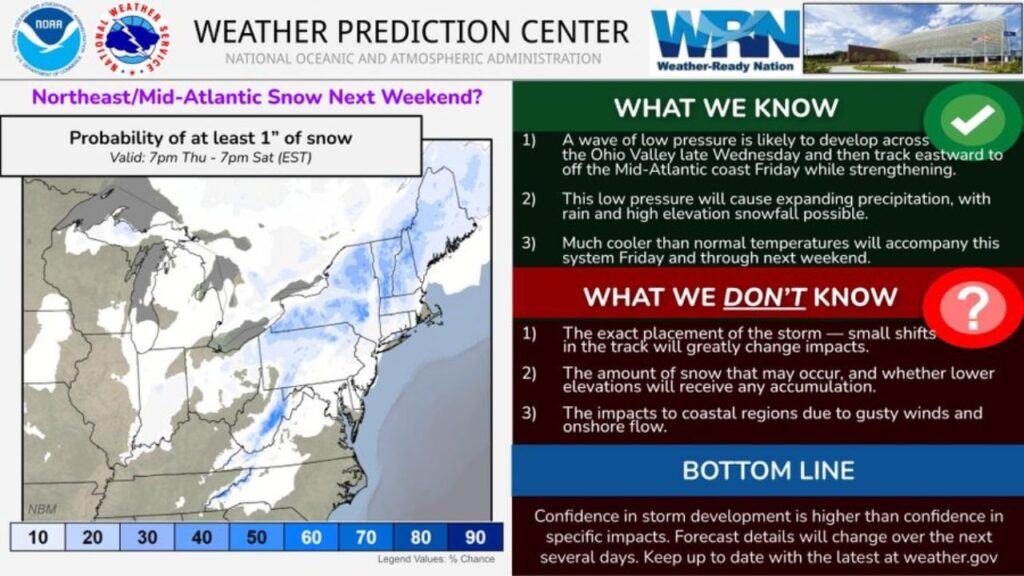
- A wave of low pressure is likely to form over the Ohio Valley late Wednesday
- The low will track east and move off the Mid-Atlantic coast on Friday, strengthening as it goes
- Precipitation will expand, with rain and high-elevation snow possible
- Much colder than normal temperatures will follow the storm from Friday into next weekend
What Forecasters Don’t Know Yet
There are still major questions:
- Exact storm track: Even small shifts could greatly change impacts
- Snow amounts: How much snow falls and whether lower elevations see any accumulation
- Coastal impacts: The strength of gusty winds and onshore flow along the coast
Chance of at Least 1 Inch of Snow, Thursday Night to Saturday Evening
Forecast probabilities for 1 inch or more of snow between 7 p.m. EST Thursday and 7 p.m. EST Saturday show the best chances in higher elevations:
| Area | Chance of 1+ Inch of Snow |
|---|---|
| Interior New England and the Adirondacks | Low to moderate |
| Catskills and higher terrain of New York | Low to moderate |
| Pennsylvania mountains | Low to moderate |
| West Virginia and Virginia mountains | Low to moderate |
| I-95 cities from Washington to Boston | Low |
| Coastal areas | Low |
Higher Elevations Have the Best Snow Chances
Because it is still early in the season and the ground and ocean are relatively warm, the best chance for snow is in mountain areas and higher terrain. Lower elevations and the coast are more likely to see rain.
Coastal Concerns: Gusty Winds and Onshore Flow
If the storm strengthens near the coast, it could bring:
- Gusty winds along the shoreline
- Onshore flow, pushing water toward the coast
- Rough surf and possible minor coastal flooding
The exact impacts depend on how close the storm tracks to land.
Confidence in the Storm Is Higher Than Confidence in Impacts
The Weather Prediction Center summed it up: confidence that the storm will develop is higher than confidence in its specific impacts. Forecast details are expected to change over the next several days.
Part of a Larger Pattern Change
This possible storm comes as the East shifts into a colder pattern, with freeze warnings already in place across the Ohio Valley and forecasts for a big chill reaching the Mid-Atlantic and even Florida next weekend.
How to Prepare Now
- Check forecast updates at weather.gov daily
- Prepare winter gear if you live in higher elevations
- Secure outdoor items in coastal areas ahead of gusty winds
- Plan travel with flexibility for late next week
Stay with Bchssreport.com for the latest updates on this story.
About The Author
