Washington’s Olympic Peninsula Faced Isolated Severe Wind Gusts Up to 60 MPH Saturday Evening as a Broken Line of Shallow Storms Moved Ashore
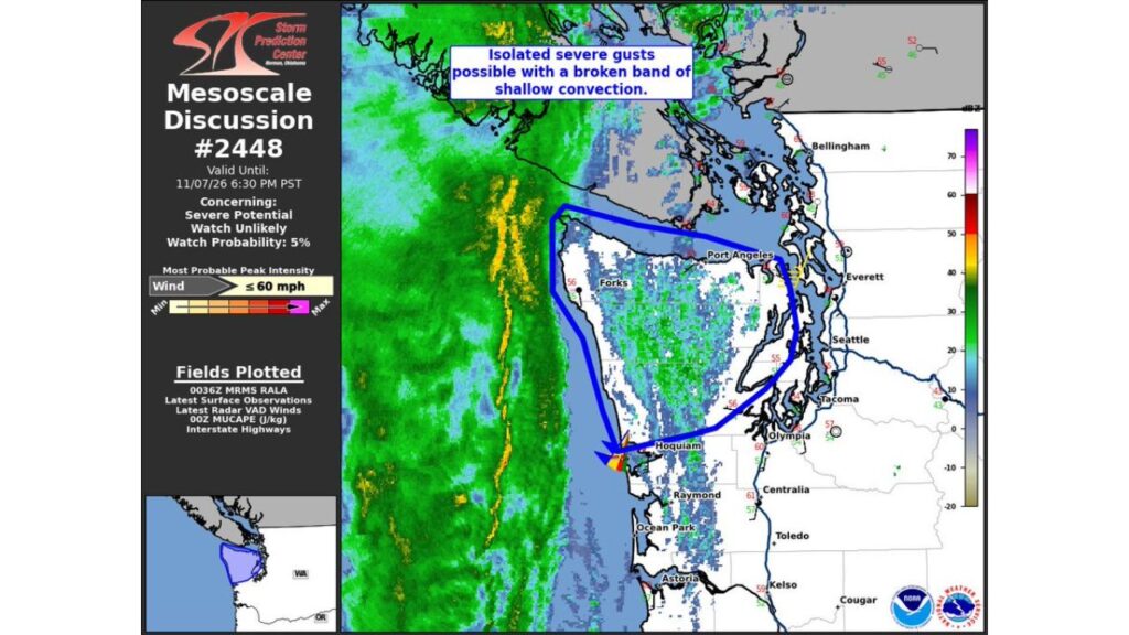
PORT ANGELES, WASHINGTON — A broken band of shallow storms moving in from the Pacific Ocean brought the potential for isolated severe wind gusts to Washington’s Olympic Peninsula on Saturday evening, November 7, 2026.
The NOAA Storm Prediction Center issued Mesoscale Discussion #2448 for the area, flagging gusts as strong as 60 mph but saying a severe weather watch was unlikely.
Mesoscale Discussion Details
| Detail | Information |
|---|---|
| Discussion number | #2448 |
| Issued | About 4:39 p.m. PST Saturday, November 7 |
| Valid until | 6:30 p.m. PST Saturday |
| Concern | Severe potential, watch unlikely |
| Watch probability | 5% |
| Most likely peak wind | Up to 60 mph |
Areas Included in the Discussion
The highlighted area covered much of the Olympic Peninsula and nearby coastal Washington, including areas near:
- Forks on the western peninsula
- Port Angeles along the Strait of Juan de Fuca
- Hoquiam near Grays Harbor
- Areas west of Puget Sound, toward Olympia
Cities like Seattle, Tacoma, Everett and Bellingham were outside the main area of concern.
A Line of Shallow Storms Pushing Ashore
Radar showed a narrow, broken line of convection, or storm activity, moving east from the Pacific toward the Washington coast. Although these storms were shallow, meaning they did not grow very tall, they were capable of producing strong, gusty winds as they moved onshore.
What “Shallow Convection” Means
Shallow convection refers to storms that stay low in the atmosphere. These storms often produce little or no lightning, but in the right setup, they can still mix strong winds from above down to the ground.
Main Hazard: Damaging Wind Gusts
The biggest concern was isolated wind gusts up to 60 mph, which could cause:
- Downed tree limbs and some trees, especially in saturated soil
- Scattered power outages
- Blowing debris
- Rough conditions along the coast and on the water
Why a Watch Was Unlikely
The Storm Prediction Center said the threat was expected to stay isolated, so issuing a severe thunderstorm watch was unlikely. Watches are generally reserved for more widespread or organized severe weather.
Part of a Stormy Pattern in the Pacific Northwest
This event is part of a series of Pacific storm systems hitting the Pacific Northwest, bringing heavy rain to the coast and high-elevation snow to the Cascades. Thunderstorms were also highlighted for western Washington in Saturday’s national outlook.
Safety Tips for Strong Winds
- Secure outdoor items like patio furniture
- Avoid parking under large trees
- Charge phones and keep flashlights handy
- Use caution on coastal roads like U.S. 101
- Boaters should stay off rough waters
Outlook: More Rain and Wind Possible
With more storms lined up off the Pacific, the Olympic Peninsula and western Washington could see additional rounds of rain and gusty winds in the coming days.
Stay with Bchssreport.com for the latest updates on this story.
About The Author
