Sedona, Arizona Orders Immediate Flood Evacuations for Zones 8, 9 and 10 as Oak Creek Rises Fast and Red Rock High School Is Cleared
SEDONA, ARIZONA — Officials in Sedona have placed Evacuation Zones 8, 9 and 10 in “GO” status, ordering residents to get out now as Oak Creek rises rapidly and the risk of sudden flooding grows.
Sedona Red Rock High School has also been ordered to evacuate.
What “GO” Status Means
Under Arizona’s Ready, Set, Go! evacuation system, “GO” means leave immediately. Danger is current or imminent, and residents should not wait to gather belongings.
| Zone | Status |
|---|---|
| Sedona Zone 8 | GO, evacuate now |
| Sedona Zone 9 | GO, evacuate now |
| Sedona Zone 10 | GO, evacuate now |
| Sedona Red Rock High School | Evacuate |
Where the Evacuation Zones Are Located
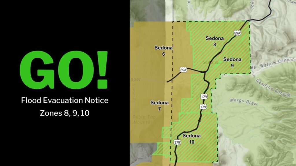
The evacuation map shows the GO zones running along the Oak Creek corridor in and around Sedona:
- Zone 8: Along State Route 89A in the northern part of the area
- Zone 9: East of 89A, near Bear Wallow Canyon
- Zone 10: Farther south along State Route 179, near Margs Draw and Damfino Canyon
Neighboring Zones 6 and 7, to the west near Table Top Mountain, are shown in a separate shade on the map. Residents in those areas should check the official county map for their current status.
Oak Creek Rising Fast
Officials warned that Oak Creek is rising fast, bringing a serious risk of sudden flooding. Creeks in steep canyon terrain like Sedona’s can rise within minutes, leaving little time to react.
Do Not Cross Running Water on Roads
Officials repeated a strong warning: do not cross roads when there is running water. Even shallow, moving water can sweep vehicles away, and floodwater can hide damaged pavement and debris.
Stay Away From Creek Beds and Drainages
Residents were also told to stay away from creek beds, washes and drainage channels. These areas can fill suddenly with fast-moving water as heavy rain runs off surrounding canyons and slopes.
Part of a Major Southwest Flood Event
This evacuation comes as an atmospheric river brings near-record moisture into the Southwest. Forecasters have warned of 3 to 5 inches of rain along the Mogollon Rim, with rainfall in some spots reaching levels seen only about once every 100 years. With ground already soaked, most of that water is expected to run off into creeks like Oak Creek.
Where to Find Evacuation Information
Residents can learn more about the Ready, Set, Go! system at ein.az.gov/ready-set-go and should check the Coconino County Evacuation Map for the latest zone updates.
What to Do If You Are in a GO Zone
- Leave immediately using the safest route
- Do not drive through running water
- Take only essentials, such as medications, documents and pets
- Avoid creek crossings and low spots
- Follow directions from law enforcement and emergency crews
What to Do If You Are Near a GO Zone
- Be ready to leave quickly
- Keep your vehicle fueled
- Monitor official alerts from Coconino County and the City of Sedona
- Stay away from creeks and washes
Outlook: Flood Danger Continues as Rain Falls
With heavy rain still falling across northern Arizona, officials warn that conditions could change quickly. Residents across the Sedona area should stay alert and follow official instructions.
Stay with Bchssreport.com for the latest updates on this story.
About The Author
