Flash Flood Emergency Declared in Pearl River County, Mississippi as Radar Estimates Nearly 19.4 Inches of Rain in Just 6 Hours, Flooding Roads and Structures
PEARL RIVER COUNTY, MISSISSIPPI — A Flash Flood Emergency, the most serious type of flood alert, was issued for part of Pearl River County, Mississippi, late Saturday, October 31, 2026, after a storm dumped an estimated 19.4 inches of rain in just six hours.
Several roads and some structures were reported flooded, and the emergency remained in effect through 12:45 a.m. Sunday, November 1.
Flash Flood Emergency Details
| Detail | Information |
|---|---|
| Alert Type | Flash Flood Emergency |
| Location | Pearl River County, Mississippi |
| In Effect Until | 12:45 a.m. Sunday, November 1 |
| Peak 6-Hour Rainfall Estimate | 19.4 inches |
| Data Time | 11:10 p.m. CDT Saturday, October 31 |
| Reported Impacts | Several roads and some structures flooded |
What a Flash Flood Emergency Means
A Flash Flood Emergency is issued only when there is a severe threat to life and catastrophic damage from flash flooding is happening or about to happen. It is a step above a regular flash flood warning.
19.4 Inches of Rain in Six Hours
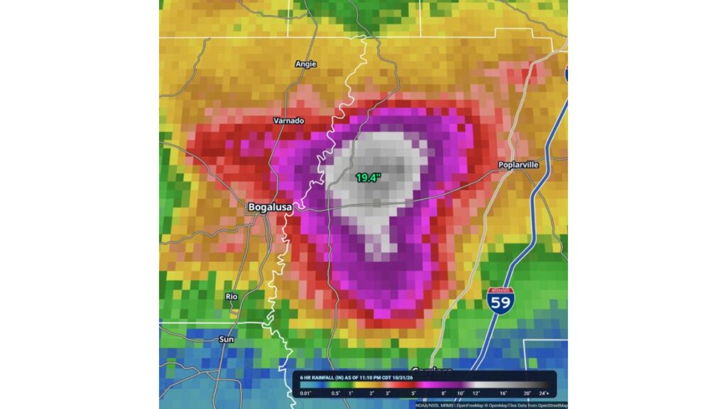
Radar-based rainfall estimates from NOAA’s MRMS system showed a stunning 19.4 inches of rain in a six-hour window ending at 11:10 p.m. CDT.
That amount is more than many places receive in several months, falling in just one evening.
Bullseye Between Bogalusa and Poplarville
The heaviest rain was concentrated in a small area east of the Pearl River, between Bogalusa, Louisiana, and Poplarville, Mississippi:
| Area | Estimated 6-Hour Rainfall |
|---|---|
| Core of the storm, Pearl River County | About 12 to 19.4 inches |
| Ring around the core | About 8 to 12 inches |
| Outer ring, including near Bogalusa | About 3 to 8 inches |
| Near Varnado and Poplarville | About 3 to 5 inches |
| Near Angie | About 2 to 3 inches |
| Near Rio, Sun and Carriere | About 0.5 to 2 inches |
Totals Drop Off Sharply Outside the Storm
Just a few miles from the bullseye, rainfall dropped dramatically. Areas along Interstate 59 to the east and communities south toward Carriere saw far less rain, showing how narrow and intense this storm was.
Storm Stalled for Hours Over the Same Area
This extreme rainfall happened because the storm stalled over the same small area for hours, even though the day’s forecast had only called for scattered storms and a marginal flood risk.
Roads and Structures Flooded
Officials reported several roads flooded and some structures affected by rising water. Additional details on damage, rescues or injuries had not been released.
Flash Flood Safety in Pearl River County
- Do not travel unless absolutely necessary
- Never drive into flooded roads, especially at night
- Move to higher ground if water enters your home
- Avoid creeks, ditches and low spots
- Call 911 if you are trapped by floodwater
After the Water Recedes
- Stay off damaged roads and bridges
- Avoid contact with floodwater, which may be contaminated
- Document damage with photos for insurance
- Follow local officials for cleanup and road updates
Outlook: Recovery and Damage Assessments Ahead
Once the flood emergency ends, officials are expected to assess damage to roads, homes and businesses in the hardest-hit parts of Pearl River County.
Stay with Bchssreport.com for the latest updates on this story.
About The Author
