Florida Soaked by Numerous Showers and Storms Sunday From Panama City to Key West as Heavy Rain Targets North Port, Miami and South-Central Florida
FLORIDA — November is usually one of Florida’s driest months, but Sunday, November 1, 2026, is a big exception. Numerous showers and thunderstorms are moving across the state, and the wet weather is expected to continue into the second half of the day.
Residents are being urged to bring an umbrella and plan accordingly.
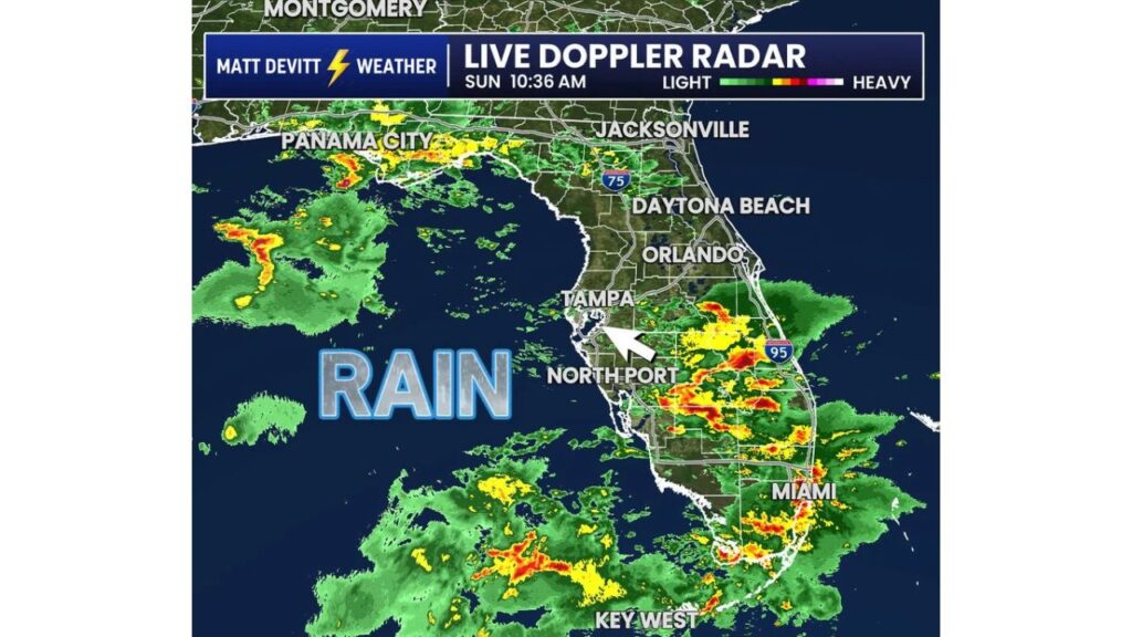
Radar Snapshot: Sunday Morning, 10:36 a.m.
Live Doppler radar at 10:36 a.m. Sunday showed rain spread across much of the state:
| Area | Radar Activity |
|---|---|
| South-central Florida, near North Port | Heavy rain and storms |
| East of Lake Okeechobee toward I-95 | Heavy rain and storms |
| Miami and Southeast Florida | Moderate to heavy rain |
| Florida Keys and waters near Key West | Heavy storms offshore |
| Florida Panhandle near Panama City | Showers and storms |
| Gulf of Mexico west of Florida | Bands of heavy rain offshore |
| Jacksonville area | Light showers |
| Tampa area | Light rain on the edge |
| Orlando and Daytona Beach | Mostly light or dry |
Heaviest Rain Across South-Central Florida
The most intense activity on radar stretched across south-central Florida, from areas near North Port east across the interior toward I-95 on the Atlantic coast. Bright red and orange colors on radar showed heavy downpours and thunderstorms in this region.
Miami and Southeast Florida Also Getting Hit
Storms also moved through Miami and much of Southeast Florida, with pockets of heavy rain that could cause ponding on roads and in parking lots.
Storms Over the Florida Keys and Key West
South of the mainland, strong storms were churning over the waters near the Florida Keys and Key West, with some heavier cells that could bring gusty winds and lightning.
Panhandle Rain Near Panama City
In the Florida Panhandle, showers and storms moved through areas near Panama City, with more rain offshore in the Gulf.
North and Central Florida Seeing Lighter Rain
Around Jacksonville, Tampa, Orlando and Daytona Beach, radar showed mostly light rain or dry pockets at the time, though more showers could develop later in the day.
Why Florida Is So Wet This Weekend
This rainy setup is tied to an upper-level low expected to stall over Florida, along with converging winds and a front across the state. That pattern helps storms form repeatedly, especially across central and eastern Florida.
Flood Risk Remains Elevated for Eastern Florida
Much of eastern Florida is under a Level 2 of 4 risk for flash flooding on Sunday and Monday, with some areas expected to pick up several inches of rain.
Tips for a Rainy Sunday in Florida
- Carry an umbrella and rain gear
- Avoid driving through flooded roads
- Turn headlights on in heavy rain
- Head indoors when you hear thunder
- Watch for flood advisories on your phone
Outlook: Rain Continues Into Sunday Afternoon and Monday
Showers and storms are expected to continue through the afternoon, with more heavy rain possible into Monday. Residents should stay alert and adjust outdoor plans as needed.
Stay with Bchssreport.com for the latest updates on this story.
About The Author
