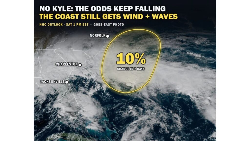
Storm Off the Southeast Coast Has Just a 10% Chance of Becoming Kyle, but Carolinas to Mid-Atlantic Still Face Heavy Rain, Rip Currents and Coastal Flooding
CHARLESTON, SOUTH CAROLINA — The storm system churning off the Southeast coast is now unlikely to become Tropical or Subtropical Storm Kyle. The National Hurricane Center lowered its development chances to just 10% over the next seven days in its outlook issued at 1 p.m. EST Saturday, November 21, 2026.
Even without a name, the storm is still expected to bring gusty winds, dangerous surf, rip currents and coastal flooding from the Southeast to the Mid-Atlantic coast into early next week.
Development Chances at a Glance
| Detail | Information |
|---|---|
| Outlook issued | 1 p.m. EST Saturday, November 21 |
| Chance of development | 10% within 7 days |
| Location | Off the Southeast coast, east of Charleston and Jacksonville |
| Movement | North, toward the waters off the Carolinas and Virginia |
| Next name on the list | Kyle |
Why the Odds Keep Falling
The system is moving north into an area where conditions will not allow it to become tropical. Cooler ocean waters and stronger upper-level winds farther north make it hard for a storm to develop the warm, organized core that tropical systems need.
Satellite images on Saturday showed a large swirl of clouds off the coast, stretching from waters east of Jacksonville and Charleston north toward Norfolk, Virginia.
Coastal Hazards Continue Into Early Next Week
Whether or not it gets a name, the storm is strong enough to cause problems along the coast:
| Hazard | Areas at Risk |
|---|---|
| Gusty winds | Southeast coast to the Mid-Atlantic |
| Dangerous surf | Beaches from Florida to Virginia |
| Rip currents | Southeast and Mid-Atlantic beaches |
| Coastal flooding | Low-lying coastal areas, especially at high tide |
| Heavy rain and flash flooding | Coastal Carolinas and Mid-Atlantic this weekend |
Heavy Rain for the Coastal Carolinas and Mid-Atlantic
The storm is pulling Atlantic moisture onshore, bringing heavy rain and a risk of flash flooding to the coastal Carolinas and Mid-Atlantic this weekend. Rain totals of 0.50 to 1 inch are expected along the Carolina and Virginia coasts, with 1 to 2 inches possible farther north along the Northeast coast into Monday.
Rip Currents Are a Serious Danger
Even on days when the sky clears, rip currents can remain deadly. These strong, narrow currents can quickly pull swimmers away from shore. Beachgoers should:
- Stay out of the water when rip current warnings are posted
- Swim near lifeguards if entering the water
- Swim parallel to shore if caught in a rip current, then head back to land
Coastal Flooding at High Tide
Strong onshore winds can push water toward the coast, causing minor to moderate flooding in low-lying areas, especially around high tide. Areas such as the Outer Banks, Charleston and Hampton Roads often see flooded roads during these setups.
A Late-Season Storm Worth Watching
The storm drew attention because it could have become the last named storm of the 2026 Atlantic hurricane season, which officially ends on November 30. With chances now down to 10%, the name Kyle may go unused this year.
Safety Tips for Coastal Residents
- Avoid driving through flooded coastal roads
- Secure boats and outdoor items ahead of gusty winds
- Watch high tide times for flood-prone areas
- Keep weather alerts on for flash flood warnings
Outlook: Conditions Improve Later Next Week
As the storm moves farther north and away from the coast, winds and surf are expected to slowly ease by midweek. However, another round of heavy rain is possible across the East ahead of Thanksgiving.
Stay with Bchssreport.com for the latest updates on this story.
About The Author
