North Carolina and Tennessee Mountains Brace for First Snow of the Season Friday Into Sunday as a Blast of Cold Air Arrives, While Charlotte Stays Sunny, Cool and Windy
BOONE, NORTH CAROLINA — The first real blast of cold air of the season is set to arrive Thursday night, November 12, 2026, settling in on Friday and sticking around through the weekend.
While the Piedmont, including Charlotte, will see sunshine, parts of the Tennessee and North Carolina mountains are expecting their first snow of the season.
Cold Air Timeline
| Time | What to Expect |
|---|---|
| Thursday night, Nov. 12 | Cold air begins pushing in |
| Friday, Nov. 13 | Cold settles in, mountain snow begins |
| Saturday, Nov. 14 | Snow showers continue in the high country |
| Sunday morning, Nov. 15 | Snow winds down, cold lingers |
How the Mountains Make Their Own Snow
The snow will come from a classic northwest flow setup. Winds from the northwest push moist air up the slopes of the Appalachian Mountains. As the air rises and cools, it wrings out its moisture as snow, especially on higher ridges and northwest-facing slopes.
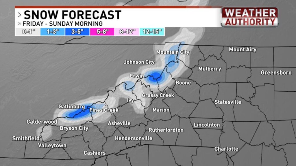
Expected Snow Totals, Friday Through Sunday Morning
| Area | Forecast Snow |
|---|---|
| Highest peaks in the Smokies near Gatlinburg | Up to about 3 inches |
| Mountains near Erwin, Grassy Creek and the Roan area | About 1 to 3 inches |
| Mountain City and the Johnson County high country | About 1 to 3 inches |
| Boone and the High Country | Dusting to 1 inch |
| Fines Creek and Bryson City areas | Dusting to 3 inches, highest at elevation |
| Asheville, Hendersonville and Marion | Little to none |
| Charlotte, Greensboro and the Piedmont | No snow |
Highest Totals on the Peaks
The heaviest snow is expected on the highest peaks, where totals could reach about 3 inches. Two main areas stand out:
- The Great Smoky Mountains near Gatlinburg
- The mountains near Erwin and the Tennessee-North Carolina border
“Not a Lot, but It’s a Start”
Forecasters admit the totals are modest, ranging from a dusting in lower elevations to a few inches on the tallest peaks. Still, it marks a sign that winter is beginning in the Southern Appalachians.
No Snow for the Piedmont, but Cool and Windy
For areas east of the mountains, including Charlotte, Statesville, Lincolnton, Greensboro and Mount Airy, there will be no snow. Instead, expect:
- Plenty of sunshine
- Cool temperatures
- Gusty winds
Part of a Wider Cold Snap Across the South
This first mountain snow is part of a broader cold pattern spreading across the eastern U.S., including:
- Mountain snow in East Tennessee and Southwest Virginia
- Below-normal temperatures in the Tennessee Valley
- A sharp cool-down reaching Florida, where falling iguanas are possible
Travel Tips for the Mountains
- Watch for slick spots on high-elevation roads
- Check conditions before driving through Newfound Gap or other mountain passes
- Carry warm layers and emergency supplies
- Expect gusty winds that may bring down small branches
Outlook: Cold Holds Through the Weekend
The cold air is expected to stay through the weekend, keeping mornings chilly across the Carolinas and Tennessee even after the mountain snow ends.
Stay with Bchssreport.com for the latest updates on this story.
About The Author
