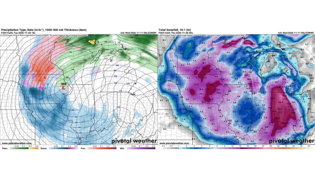
Midwest “Snowicane” Talk Goes Viral as One Long-Range Forecast Shows a Thanksgiving-Week Storm Dumping Up to 20 Inches on Indiana and Ohio, but Forecasters Urge Caution
MIDWEST — Social media is buzzing after one long-range forecast showed a powerful winter storm sweeping across the Midwest just before Thanksgiving, with some jokingly calling it a “Category 1 snowicane.”
One viral post even quipped that the storm could take the next name on the Atlantic hurricane list, “Kyle,” as the last named storm of the 2026 season. That part is just a joke: winter storms are not named from the hurricane list, and there is no such thing as an official “snowicane” category.
What the Long-Range Forecast Shows
The viral maps come from a single model run issued on Wednesday, November 11, looking about two weeks ahead:
| Detail | What the Forecast Shows |
|---|---|
| Storm timing | Tuesday, Nov. 24, into Wednesday, Nov. 25 |
| Low pressure center | About 985 millibars near northeast Iowa and southwest Wisconsin |
| Snow zone | Iowa, Minnesota, Missouri, Illinois, Indiana, Ohio, Michigan and Kentucky |
| Mixed precipitation | Freezing rain and sleet in parts of Minnesota and northern Iowa |
| Rain | Wisconsin and Michigan’s Upper Peninsula |
A Strong Low Spinning Over the Upper Midwest
At noon CST on Tuesday, November 24, the forecast places a 985-millibar low near the Iowa, Wisconsin and Illinois border area. Snow wraps around the west and south sides of the storm, while freezing rain and sleet show up farther north and rain falls to the northeast.
Eye-Popping Snow Totals in This One Run
Total snow through the evening of Wednesday, November 25, in this single forecast:
| Area | Snow in This Forecast |
|---|---|
| Eastern Indiana and western Ohio | About 15 to 21.6 inches |
| Southern Michigan near the Ohio line | About 13 to 16 inches |
| Michigan’s Upper Peninsula | Up to about 18.5 inches |
| Iowa and southern Minnesota | About 9 to 13 inches |
| Kentucky | About 9 to 14 inches |
| Missouri | About 6 to 9 inches |
| Lake Michigan shoreline areas | About 10 to 11 inches |
| Central Illinois | About 3 to 7 inches |
| Wisconsin | About 3 to 11 inches |
Why Forecasters Say Not to Panic Yet
This forecast is about two weeks away, and long-range models often:
- Shift storm tracks by hundreds of miles
- Overestimate or underestimate snow totals
- Change dramatically from one run to the next
A single run showing a big storm does not mean it will happen. Forecasters will need to see consistency over many days before confidence increases.
Bad Timing if It Happens: Thanksgiving Travel
If a storm like this were to develop, it would hit during one of the busiest travel periods of the year, right before Thanksgiving Day on November 26. That would mean potential impacts to roads and airports across the Midwest.
A Colder Pattern Is Taking Shape
While the exact storm is uncertain, the overall pattern is turning colder, with a midweek cold front, lake-effect snow chances in northwest Indiana, and mountain snow in East Tennessee and Utah in the coming days.
How to Prepare Without Overreacting
- Watch forecasts as Thanksgiving week approaches
- Build flexibility into holiday travel plans
- Prepare winter car kits and check tires
- Rely on trusted forecasts, not single model screenshots
Stay with Bchssreport.com for the latest updates on this story.
About The Author
