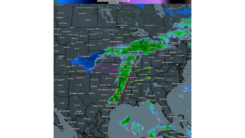
Mississippi Valley Could Face a Severe Squall Line While Colorado and Western Kansas Get Heavy Snow in a Long-Range Forecast for the Weekend Before Thanksgiving
ST. LOUIS, MISSOURI — Another long-range forecast is grabbing attention as Thanksgiving approaches. This one shows a powerful storm system producing a severe line of thunderstorms from Texas to Illinois, with heavy snow on the cold backside across Colorado, western Kansas and Nebraska.
Forecasters stress that this is certainly not locked in, but say it is a setup worth keeping an eye on.
Forecast Timing
| Detail | What the Forecast Shows |
|---|---|
| Forecast valid | Early Sunday morning, November 22, 2026 |
| Lead time | About 12 days out |
| Main threats | Severe line of storms and backside snow |
| Storm movement | East toward the Ohio and Tennessee Valleys |
A Severe Line of Storms From Texas to Illinois
The forecast shows a long, narrow line of storms stretching north to south across the Mississippi Valley, roughly from:
- East Texas, near Lufkin
- Through western Louisiana near Monroe
- Across eastern Arkansas, near Jonesboro
- Up to the St. Louis area and into Illinois near Quincy
A line like this could bring damaging winds, heavy rain and possibly tornadoes if it develops as shown.
Storms Pushing East Toward Kentucky and Tennessee
Arrows on the forecast map show the line moving east, toward:
- Louisville and Kentucky
- Tennessee, including areas near Memphis and Clarksville
That could put more of the Ohio and Tennessee Valleys in the path of storms later on Sunday.
Heavy Snow on the Backside
On the cold side of the storm, the forecast shows snow across:
| Area | Precipitation Type in This Forecast |
|---|---|
| Eastern Colorado, including Lamar | Snow |
| Northern Colorado and southeast Wyoming near Cheyenne | Snow |
| Western Kansas, including Liberal | Snow |
| South-central Nebraska near Kearney | Snow |
Rain Spreads Across the Midwest and Great Lakes
Ahead of the storm, a large shield of rain extends north across:
- Missouri and Iowa
- Illinois and Wisconsin
- Michigan
- Parts of Ontario
How This Fits With Other Long-Range Forecasts
This is not the first dramatic forecast showing a big storm near Thanksgiving. Other recent model runs have shown:
- An extremely deep cutoff low over the Midwest around November 24
- A major snowstorm with up to 20 inches in parts of Indiana and Ohio
Each forecast shows the storm with different timing and placement, which highlights how uncertain the pattern still is.
Why Forecasters Urge Caution
Forecasts this far out often:
- Change the timing of storms by days
- Shift storm tracks by hundreds of miles
- Weaken or strengthen systems from one run to the next
Still, repeated signals of a strong storm near Thanksgiving week are getting attention.
What This Could Mean for Thanksgiving Travel
If a storm like this develops, it could impact some of the busiest travel days of the year, including:
- Road travel across the Plains, Midwest and South
- Flights through major hubs like St. Louis, Dallas, Denver and Chicago
How to Prepare Now
- Keep travel plans flexible
- Watch for updated forecasts over the next week
- Prepare your car for both storms and snow
- Review severe weather plans if you live in the South
Stay with Bchssreport.com for the latest updates on this story.
About The Author
