Midwest Could See a Monster Storm System Near Thanksgiving as One Long-Range Forecast Shows an Extremely Powerful Cutoff Low Spinning Over Illinois
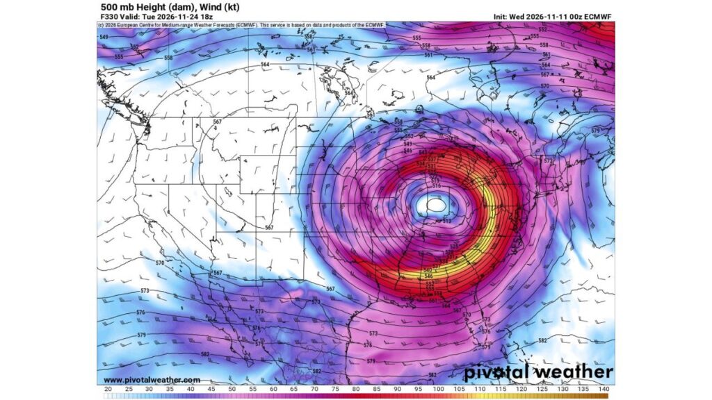
CHICAGO, ILLINOIS — A single long-range forecast is turning heads in the weather community after showing one of the strongest upper-level storm systems some forecasters say they have ever seen modeled, spinning directly over the Midwest just before Thanksgiving.
One forecaster described it as “the strongest cutoff low I’ve ever seen modeled,” calling it very impressive.
What the Forecast Shows
The forecast, from a model run issued Wednesday, November 11, 2026, looks ahead to noon CST on Tuesday, November 24, about two weeks out.
| Detail | What the Forecast Shows |
|---|---|
| Forecast valid | Noon CST Tuesday, November 24 |
| Storm type | Cutoff low at about 18,000 feet (500 mb level) |
| Center location | Northern Illinois area |
| Lowest heights near center | About 513 decameters |
| Strongest upper winds | Over 120 knots across the Southeast |
What Is a Cutoff Low?
A cutoff low is an area of low pressure high in the atmosphere that becomes separated from the main jet stream. Because it is “cut off,” it can stall or move slowly, sometimes bringing days of stormy weather to the same region.
Why This One Stands Out
This forecast shows the cutoff low with extremely low heights near its center, around 513 decameters, which is exceptionally deep for mid-to-late November over the central U.S.
That kind of setup can support:
- Heavy snow on the cold side of the storm
- Strong winds across a large area
- Severe storms on the warmer side to the south and east
A Powerful Jet Stream Wrapping Around the Storm
The forecast shows an intense jet stream wrapping around the storm, with winds of 100 to 130+ knots high in the atmosphere. The strongest winds stretch from:
- Texas and Louisiana
- Across Mississippi, Alabama and Georgia
- North into the Ohio Valley and Appalachians
Links to Viral Snowstorm Forecasts
This same forecast run is the one that showed a major snowstorm across the Midwest with up to 20 inches in parts of Indiana and Ohio, which some jokingly called a “snowicane” on social media.
Why Forecasters Urge Caution
Even though the forecast looks dramatic, it is about two weeks away, and long-range models often:
- Shift storm locations significantly
- Change the storm’s strength from run to run
- Drop extreme scenarios altogether
A storm this strong would need to show up consistently across multiple forecasts before confidence increases.
Possible Impacts if a Storm Like This Develops
If something similar does happen, it could bring:
- Heavy snow to parts of the Midwest and Great Lakes
- Severe thunderstorms in the South
- Strong winds across a wide area
- Major travel disruptions during Thanksgiving week
Thanksgiving Travel Timing
The forecast timing lands right before Thanksgiving on November 26, one of the busiest travel periods of the year. Even a weaker version of this storm could affect roads and airports.
How to Stay Prepared
- Follow trusted forecasts as the holiday gets closer
- Plan flexible travel if possible
- Prepare winter car kits
- Avoid sharing single model screenshots as certain forecasts
Outlook: Something to Watch, Not Worry About Yet
For now, this is a long-range signal worth watching. Forecasters will be looking to see whether future runs keep showing a powerful storm near Thanksgiving week.
Stay with Bchssreport.com for the latest updates on this story.
About The Author
