
Heavy Rain and Flash Flood Threat Builds Across Oklahoma and Texas This Week as Hurricane Polo Remnants and Gulf Moisture Could Dump 5 to 7+ Inches
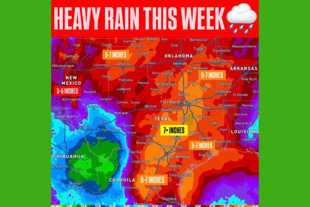
Oklahoma and Texas – A major change in the weather pattern is on the way for Oklahoma and Texas this week. Multiple rounds of showers and storms are expected to produce widespread heavy rainfall and an increasing risk of flash flooding across a large part of the Southern Plains. Some projections show rainfall totals of 5 to 7 inches across broad areas, with 7 inches or more possible in parts of Central Texas.
How the Setup Comes Together
Several powerful weather ingredients are lining up at the same time. A strong upper-level storm is moving out of the Southwest, while deep tropical moisture tied to the remnants of Hurricane Polo is being pulled northeast into the Southern Plains. At the same time, moisture from the Gulf is surging northward.
When these features combine, they could create an unusually moisture-rich atmosphere capable of producing very efficient rainfall. In simple terms, storms that develop in this environment will be able to dump large amounts of rain in a short amount of time.
Texas Panhandle and Amarillo: Heavy Rain Tuesday Into Wednesday
The first significant impacts are expected across West Texas and the Texas and Oklahoma Panhandles. Rain chances increase Monday night before becoming much more widespread Tuesday into Wednesday.
Across the Amarillo area, several rounds of heavy rain are expected, with the most intense rainfall rates currently favored from Tuesday evening into Wednesday morning. Flooding is an elevated concern here because parts of the region have already received significant rainfall recently, leaving the ground less able to soak up additional water. Rainfall projections show 5 to 7 inches possible across parts of the Panhandle region.
Lubbock, South Plains, and Rolling Plains
Farther south across the South Plains and Rolling Plains, including the Lubbock region, the heaviest and most widespread rain is also expected Tuesday into Wednesday. Flooding will be possible as repeated storms move over the same areas.
West Central Texas, including areas around Abilene, is expected to see scattered to numerous storms, with an increased potential for heavy rain and flash flooding Tuesday through Thursday.
West Texas and the Permian Basin: Tuesday the Wettest Day
West Texas and the Permian Basin are another area to watch closely. The combination of Polo’s tropical moisture and Gulf moisture could push atmospheric moisture levels toward or even above daily record values on Tuesday.
Tuesday currently looks like the wettest day for this region. Heavy rain capable of producing flash flooding is the main concern, particularly along and north of the Pecos River.
Oklahoma: Widespread Rain Tuesday Night Through Friday
The heavy rain threat will then expand farther east. Across much of Oklahoma, widespread rainfall is expected to begin Tuesday night and continue through Friday. Some of the heaviest totals are currently favored Wednesday night into Thursday.
Eastern Oklahoma may stay unsettled from Wednesday through at least Friday and possibly into next weekend. With several rounds of rain, totals could add up quickly. Projections show 5 to 7 inches possible across parts of southeastern Oklahoma, including areas around McAlester, with heavy rain also extending toward Tulsa, Norman, Ada, and Durant.
North and Central Texas Turn Much Wetter
North and Central Texas will turn much wetter from Wednesday through the weekend. The Dallas-Fort Worth Metroplex, Denton, Waco, and surrounding communities could see several rounds of heavy rain.
Central and South-Central Texas will start the week hot and relatively dry, but rain chances increase beginning Tuesday night, with a much wetter pattern expected Wednesday through Saturday. Some of the highest rainfall totals on the map are focused across Central Texas, where 7 inches or more could fall in the corridor between Waco and Austin. Areas around San Antonio, New Braunfels, and South Texas could also see 5 to 7 inches.
Southeast Texas and Houston: Heaviest Rain Thursday and Friday
Across Southeast Texas, including the Houston region, periods of heavy rain may begin Wednesday, with the greatest rain chances arriving Thursday and Friday. Tropical moisture interacting with an approaching disturbance could support high rain rates, and the excessive rain threat may continue into the end of the week.
Far Southeast Texas will also see increasing rain later in the week as a front runs into the deep tropical moisture plume. Rainfall projections show 5 to 7 inches possible across parts of the region, including areas near Conroe and the Houston area.
Not Nonstop Rain, but Multiple Rounds
This will not be nonstop rain everywhere for several days. Instead, residents should expect multiple rounds of showers and storms. That pattern is important because repeated storms over the same locations can gradually saturate the ground and increase runoff. As the week goes on, flooding could become easier to develop, even with rain that might not cause problems on its own earlier in the event.
Main Window: Tuesday Through Friday
Overall, Tuesday through Friday appears to be the main window for widespread heavy rain across Oklahoma and Texas, with parts of Texas potentially staying wet into next weekend. Several inches of rain are possible across the region, with locally higher amounts wherever storms repeatedly train over the same areas.
How to Prepare Now
Residents in flood-prone areas should start preparing now. Clearing storm drains and gutters, moving valuables off basement floors, and having an emergency kit ready can make a big difference. Anyone living near creeks, rivers, or low-water crossings should pay close attention to local alerts.
Most importantly, never drive through flooded roads. Just a foot of moving water can carry away a vehicle, and many flood deaths happen when drivers try to cross water-covered roadways. When in doubt, turn around.
For more Oklahoma and Texas weather updates and flood alerts, stay with bchssreport.com.