Florida’s Space Coast Could Get Another 6 to 10 Inches of Rain Tuesday Through Thursday, Bringing a New Flood Threat to Areas Still Recovering From Earlier Deluge
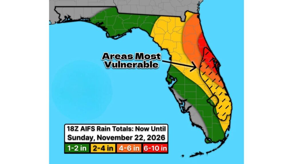
MELBOURNE, FLORIDA — Florida’s east coast may be in for another round of flooding this week. Forecast models are hinting at a flood event setting up in nearly the same areas that were hit hard earlier this month, with 6 to 10 inches of rain possible in some spots.
The flood threat is expected to begin on Tuesday, November 17, 2026, and continue through at least Thursday, November 19.
Flood Threat Timeline
| Day | What to Expect |
|---|---|
| Tuesday, Nov. 17 | Flood threat begins along the east coast |
| Wednesday, Nov. 18 | Rounds of heavy rain possible |
| Thursday, Nov. 19 | Flood threat continues |
| Through Sunday, Nov. 22 | Rain totals add up across the peninsula |
Forecast Rain Totals Through Sunday, November 22
One forecast model shows the following rain totals across Florida:
| Area | Forecast Rainfall |
|---|---|
| Space Coast, including Titusville, Melbourne and Palm Bay | 6 to 10 inches |
| Volusia County coast and Orlando’s east side | 4 to 6 inches |
| Treasure Coast, including Vero Beach and Port St. Lucie | 4 to 6 inches |
| Northeast Florida, including St. Augustine | 4 to 6 inches |
| North-central Florida and interior areas | 2 to 4 inches |
| Palm Beach County | 2 to 4 inches |
| Florida Panhandle | 1 to 2 inches |
| Tampa Bay and Southwest Florida | 1 to 2 inches |
| Miami and the Florida Keys | 1 to 2 inches |
Areas Most Vulnerable to Flooding
Forecasters highlighted an area of east-central Florida as most vulnerable, stretching from near Orlando’s east side and Brevard County, south through Okeechobee, St. Lucie and Martin counties and into northern Palm Beach County.
These areas are especially at risk because the ground is already saturated from earlier storms.
Rain Falling on Already Flooded Ground
Earlier this month, the Space Coast saw some of the heaviest rainfall in the country:
- A Flash Flood Emergency was issued for West Melbourne, Palm Bay and Grant-Valkaria
- A gauge near Palm Bay recorded 20 inches of rain in 48 hours
- Radar estimated up to 26.1 inches in the same area
- Parts of the coast reached more than 300% of normal rainfall over 30 days
Another 6 to 10 inches on top of that could quickly cause renewed flooding.
Why the East Coast Keeps Getting Hit
Florida’s east coast often sees heavy rain when onshore winds from the Atlantic push moisture inland, while storms repeat over the same areas. A strong El Niño this season may also be helping fuel a more active, wet pattern across Florida.
Forecast Still Being Fine-Tuned
This outlook is based on one model, and totals could shift north, south or change in intensity. Still, forecasters urge residents along the east coast to stay weather aware as the week goes on.
How to Prepare for Possible Flooding
- Clear storm drains and gutters near your home
- Move valuables off the floor in flood-prone areas
- Have a plan to reach higher ground
- Never drive through flooded roads
- Keep phone alerts on for flood warnings
Outlook: A Soggy Week Ahead
After a brief cool, dry weekend, the east coast of Florida may face a wet and potentially dangerous stretch heading into the middle of the week.
Stay with Bchssreport.com for the latest updates on this story.
About The Author
