Central Florida Faces Renewed Flood Threat Wednesday Through Saturday as an El Niño-Fueled System Could Dump 6 to 10+ Inches on Volusia and Brevard, With the St. Johns River Already High
ORLANDO, FLORIDA — Central Florida needs to watch the forecast closely this week. The next El Niño-fueled storm system is expected to bring heavy rain and possibly more flooding from Wednesday, November 18, through Saturday, November 21, 2026.
Forecasters say some areas could see 6 inches or more, and those numbers could end up being too low.
Storm Timeline
| Day | What to Expect |
|---|---|
| Wednesday, Nov. 18 | Rain begins spreading across Central Florida |
| Thursday, Nov. 19 | Heavy rain and storms possible |
| Friday, Nov. 20 | Additional rounds of heavy rain |
| Saturday, Nov. 21 | Rain gradually tapers |
Two Forecasts Show Big Totals for East-Central Florida
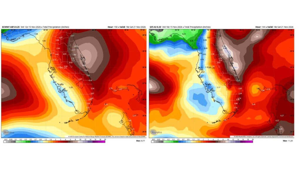
Two separate forecast models both point to heavy rain focused on east-central Florida through 1 p.m. EST Saturday:
| Area | Forecast One | Forecast Two |
|---|---|---|
| Volusia and northern Brevard coast | About 6 to 7.6 inches | About 8 to 10.4 inches |
| Seminole County and the Orlando area | About 5 to 5.3 inches | About 4 to 6.8 inches |
| Flagler and St. Johns counties | About 5.5 inches | About 7 inches |
| Indian River County | About 5.9 inches | About 5.9 inches |
| St. Lucie County | About 5.1 inches | About 5.6 inches |
| Martin County | About 4.5 inches | About 3 to 3.5 inches |
| Palm Beach County | About 3 to 3.5 inches | About 3 to 3.7 inches |
| Broward County | About 2.4 to 2.7 inches | About 3 inches |
| Miami area | About 1.9 to 2 inches | About 2.7 inches |
| Polk County | About 2.4 to 3 inches | About 1.7 to 1.9 inches |
| Tampa Bay area | About 1.5 to 2.2 inches | About 1 inch |
| Southwest Florida | About 1 inch | About 1 inch |
The highest totals reach about 8.8 inches in one forecast and about 11.2 inches in the other.
Totals Could End Up Even Higher
Forecasters note that large-scale global models often underestimate rainfall when storms become convective, meaning strong, thunderstorm-driven downpours. That means actual totals in some spots could be well above what the models show.
St. Johns River Already Running High
A major concern is the St. Johns River, which is already high after recent flash flooding in Brevard County. Additional heavy rain could push water levels even higher, raising the risk of river flooding in nearby communities.
Rain on Top of Recent Record Flooding
Earlier this month, Brevard County saw extreme rainfall, including 20 inches measured near Palm Bay in just 48 hours. With soils still saturated, even moderate rain could cause new flooding problems.
El Niño Keeps Florida Wet
A strong El Niño is helping drive an active storm track across the southern U.S. this season. Seasonal outlooks call for a much wetter than normal winter in Florida.
How to Prepare for Possible Flooding
- Clear storm drains and gutters
- Move vehicles to higher ground if you live in flood-prone areas
- Never drive through flooded roads
- Keep an emergency kit ready
- Monitor river levels if you live near the St. Johns River
Outlook: Details Still Being Worked Out
Specific rain totals and timing are still uncertain, but Central Florida residents, especially in Volusia, Brevard and Seminole counties, should stay tuned for updates.
Stay with Bchssreport.com for the latest updates on this story.
About The Author
