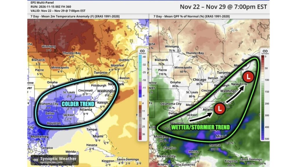
Deep South and East Coast Could Turn Cooler and Stormier During Thanksgiving Week, With Severe Weather Risk in the South and Snow Chances Farther North
ATLANTA, GEORGIA — After a dry and quiet middle part of November, the last week of the month could bring a big change for much of the eastern United States. Forecast trends point to cooler and stormier weather, especially across the Deep South.
During this period, the risk of severe weather increases in the South, while snow chances rise farther north.
Forecast Window: November 22 to November 29
The outlook covers Sunday, November 22, through Sunday, November 29, 2026, including Thanksgiving Day on November 26.
Colder Trend Across the South-Central U.S.
Temperature departures for the week show a colder trend centered on the southern Plains and Deep South:
| City | Temperature vs. Normal |
|---|---|
| Monterrey, Mexico | 5°F below |
| Oklahoma City, Oklahoma | 4°F below |
| Dallas, Texas | 4°F below |
| St. Louis, Missouri | 2°F below |
| Memphis area | 2°F below |
| Jackson, Mississippi | 2°F below |
| Atlanta, Georgia | Near normal |
| Cincinnati, Ohio | Near normal |
| Washington, D.C. | Near normal |
| Raleigh, North Carolina | Near normal |
| Miami, Florida | Near normal |
Warmer in the North
Meanwhile, the northern tier stays warmer than normal:
| City | Temperature vs. Normal |
|---|---|
| Winnipeg, Manitoba | 7°F above |
| Thunder Bay, Ontario | 5°F above |
| Bismarck, North Dakota | 5°F above |
| Pierre, South Dakota | 5°F above |
| Minneapolis, Minnesota | 4°F above |
| Montreal and Quebec | 4°F above |
| Omaha, Nebraska | 2°F above |
Wetter and Stormier From the Gulf Coast to the Northeast
The precipitation outlook shows a wetter, stormier trend stretching from Texas and the Gulf Coast up the East Coast to the Northeast:
| City | Precipitation vs. Normal |
|---|---|
| Havana, Cuba | 300% |
| Miami, Florida | 230% |
| Washington, D.C. | 215% |
| Monterrey, Mexico | 195% |
| Houston, Texas | 175% |
| Oklahoma City, Oklahoma | 135% |
Drier Across the Midwest and Upper Plains
Farther north and west, the outlook leans drier than normal:
| City | Precipitation vs. Normal |
|---|---|
| Toronto, Ontario | 90% |
| Chicago, Illinois | 85% |
| Detroit, Michigan | 85% |
| Omaha, Nebraska | 85% |
| St. Louis, Missouri | 80% |
| Bismarck, North Dakota | 70% |
| Minneapolis, Minnesota | 60% |
Storm Track From the Deep South to New York
The outlook highlights a possible storm track with low pressure developing near the Deep South and moving northeast along the East Coast toward New York. A track like this could bring:
- Severe thunderstorms in the South
- Heavy rain along the East Coast
- Snow in interior areas farther north
Why the Pattern Is Shifting
A strong El Niño is helping drive a more active subtropical jet stream across the southern U.S., which can fuel frequent storms along the Gulf Coast and East Coast during late fall and winter.
What It Means for Thanksgiving Travel
If the pattern holds, Thanksgiving travelers could face:
- Storm delays across the South and East Coast
- Wet roads on I-95, I-85 and I-10
- Possible snow in parts of the interior Northeast
How to Prepare
- Watch forecasts as the holiday approaches
- Keep travel plans flexible
- Review severe weather safety plans in the South
Stay with Bchssreport.com for the latest updates on this story.
About The Author
