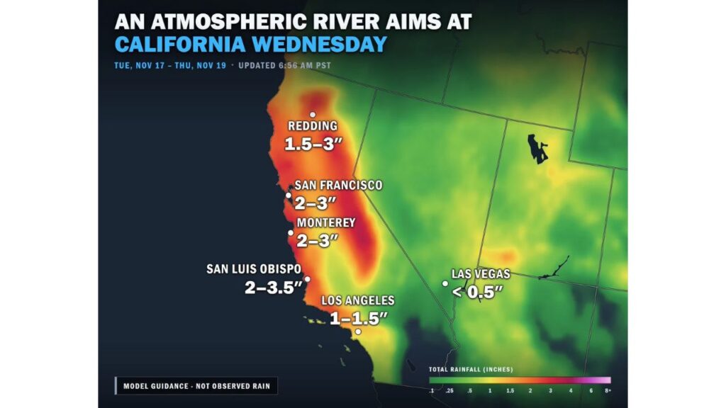
California Braces for an Atmospheric River Wednesday, With Up to 3.5 Inches of Rain From the Bay Area to San Luis Obispo and 1 to 1.5 Inches Possible in Los Angeles
SAN LUIS OBISPO, CALIFORNIA — An atmospheric river is aiming directly at California this week, bringing heavy rain, a flood risk along the Central Coast and heavy snow in the Sierra Nevada.
The heaviest rain is expected on Wednesday, November 18, 2026, before the moisture shifts into Southern California on Thursday, November 19.
Storm Timeline
| Day | What to Expect |
|---|---|
| Tuesday, Nov. 17 | Rain begins in Northern California |
| Wednesday, Nov. 18 | Heaviest rain from the Bay Area to San Luis Obispo, Sierra snow |
| Thursday, Nov. 19 | Rain shifts into Southern California, including Los Angeles |
Forecast Rain Totals, Tuesday Through Thursday
| City | Forecast Rainfall |
|---|---|
| San Luis Obispo | 2 to 3.5 inches |
| San Francisco | 2 to 3 inches |
| Monterey | 2 to 3 inches |
| Redding | 1.5 to 3 inches |
| Los Angeles | 1 to 1.5 inches |
| Las Vegas | Less than 0.5 inch |
These totals are based on model guidance, not observed rain, and could still change.
Wednesday: Heaviest Rain Along the Coast
The core of the atmospheric river is expected to hit Wednesday, with 2 to 3.5 inches possible from the San Francisco Bay Area down through Monterey and San Luis Obispo. That much rain in a short time raises a risk of flooding along the Central Coast.
Thursday: Rain Reaches Southern California
On Thursday, the rain shifts south into Southern California. Los Angeles could pick up 1 to 1.5 inches, which would be a significant soaking after a stretch of warm, dry weather and a recent Santa Ana wind event.
Heavy Snow in the Sierra Nevada
The western slopes of the Sierra Nevada are expected to see some of the highest precipitation totals in the state. At higher elevations, much of that will fall as heavy snow, which could impact mountain travel on routes like I-80 and U.S. 50.
What Is an Atmospheric River?
An atmospheric river is a long, narrow band of moisture in the atmosphere that carries water vapor from the tropics toward the West Coast. When it reaches land, it can produce heavy rain at lower elevations and heavy snow in the mountains.
Part of an Active Pacific Pattern
This storm is part of a series of systems moving into the West, which have already brought monster surf up to 50 feet along the Northern California coast. Forecasters say the stormy pattern looks likely to continue, with daily breaks between systems.
Flooding and Mudslide Concerns
Heavy rain could lead to:
- Urban flooding in cities and low-lying neighborhoods
- Rising creeks and streams along the Central Coast
- Mudslides and debris flows, especially near recent burn scars
- Rockslides on mountain and coastal roads, including Highway 1
How to Prepare
- Clear gutters and storm drains before Wednesday
- Avoid driving through flooded roads
- Check mountain road conditions before heading to the Sierra
- Stay alert if you live near burn scars or steep hillsides
- Keep phone alerts on for flood warnings
Outlook: Wet Pattern Continues
After this atmospheric river moves through, more storm systems are expected to follow, keeping much of California in an active, wet pattern heading toward Thanksgiving.
Stay with Bchssreport.com for the latest updates on this story.
About The Author
