
Central Alabama Heats Up Near 90 Degrees Before Weekend Rain and Storms Arrive, Followed by Another Surge of Cooler Fall Air Next Week
Central Alabama – Central Alabama is in for a week of changes. After another crisp, cool start, temperatures will climb quickly under sunny skies, with afternoon highs heading into the upper 80s today and closer to 90 degrees by midweek. Moisture begins returning later in the week, setting the stage for rain and storms this weekend, followed by another push of cooler, drier fall air early next week.
Cool Morning, Warm Afternoon
Tuesday started on a cool and refreshing note, but it will be back to short sleeves by the afternoon. Plenty of sunshine will allow temperatures to warm quickly, with highs reaching the upper 80s across much of the area. Dry weather will continue, with a light northeast breeze at 4 to 8 mph.
The combination of cool mornings and warm afternoons makes for a wide temperature swing during the day, so dressing in layers is a good idea for anyone heading out early.
Midweek Warmup Near 90 Degrees
Wednesday also looks mainly dry and sunny. After another pleasant morning, dry air and abundant sunshine will allow temperatures to climb closer to 90 degrees during the afternoon. It will feel more like late summer than early fall, though the lower humidity will help keep things from feeling too uncomfortable.
Humidity Returns Thursday
Things start to change on Thursday as winds shift to come from the southeast. That shift will bring moisture back into Alabama, creating a more humid feel across the region.
The added moisture could spark a few spotty afternoon showers, especially across the southern counties. Otherwise, expect a partly cloudy sky with highs near 90 degrees.
Rain and Storm Chances Increase Friday
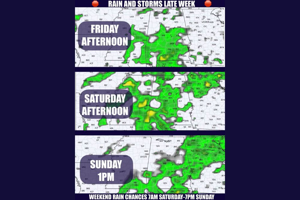
Scattered showers and storms could begin increasing as early as Friday afternoon as deeper moisture streams back into the state. Forecast guidance shows rain developing across parts of western, central, and southern Alabama during the afternoon hours, including areas around Tuscaloosa, Birmingham, and Montgomery.
At the same time, the next cold front is expected to approach Alabama by the end of the weekend.
Saturday: The Most Widespread Rain and Storms
Saturday is the day to watch for the most widespread rain and storms. Latest guidance suggests that periods of rain and storms could begin across western areas as early as Saturday morning. The rain will continue at times through Saturday afternoon and Saturday night.
Rain is then expected to gradually taper off from northwest to southeast by midday Sunday. By Sunday afternoon, most of the lingering rain should be focused across east and southeast Alabama and into Georgia, while areas farther northwest begin to dry out.
Severe Weather Risk Low
While a few thunderstorms are possible, limited instability should keep the risk for organized severe weather low. Residents may hear some thunder and see heavy downpours at times, but widespread damaging storms are not expected at this point.
How Much Rain Could Fall?
Early rainfall projections suggest that some areas could receive up to 2 inches of rain. That would be welcome news for many parts of Alabama dealing with dry conditions.
However, drought patterns can be stubborn, and forecast models sometimes overestimate rainfall amounts several days in advance. The timing and totals will become clearer as the weekend gets closer, so it is worth checking back for updates.
Weekend Travel and Football Plans
The overall message is that the weekend looks unsettled. Anyone traveling to away football games or heading out for weekend events should plan for the possibility of wet weather along the way. Packing rain gear, allowing extra travel time, and keeping an eye on the radar before hitting the road can help avoid surprises.
Tailgaters should also be prepared with tents and waterproof covers, and anyone at outdoor events should head indoors if thunder is heard.
Another Surge of Fall Air Next Week
Behind the cold front, another surge of cooler and drier air is expected to settle into Alabama next week. If current trends hold, highs could tumble into the 70s by the middle of next week, with morning lows returning to the 50s.
That would bring a true fall feel back to the state after the late-week warmth and humidity. The timing and strength of this cooler push are still being watched, but it is a promising sign for anyone ready for more autumn weather.
Tropics Update
In the Atlantic, Fay remains over the open central Atlantic and poses no threat to land. Tropical Storm Hanna is located roughly 1,000 miles east-northeast of Bermuda and is expected to stay over open water while gradually weakening.
In the eastern Pacific, Polo is forecast to make another landfall in Mexico before rapidly weakening as it moves inland across northern Mexico. Moisture from Polo is part of the larger pattern expected to bring heavy rain to parts of Texas and the Southern Plains this week.
Plan Ahead for a Changing Week
With warm afternoons, returning humidity, weekend rain, and cooler air on the way, this week will have a little bit of everything for Central Alabama. Enjoy the sunshine early in the week, get ready for a wet weekend, and look forward to more comfortable fall weather next week.
For more Alabama weather updates and storm alerts, stay with bchssreport.com.