
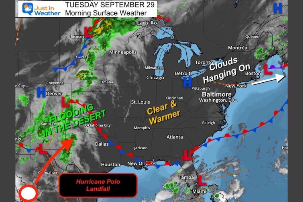
Maryland Warms Into the 70s and Near 80 Through Friday as Hurricane Polo’s Landfall in Mexico Could Bring Rain Back to the Mid-Atlantic by Sunday
Maryland – Conditions are improving across Maryland and the Mid-Atlantic after the recent nor’easter, and a stretch of warmer, sunnier days is on the way. Temperatures are expected to reach the 70s to near 80 degrees through Friday. But the weekend could bring a twist. Moisture from Hurricane Polo, which made landfall in Mexico, may ride along a stalled front and bring rain back to the region by Sunday.
Clouds Linger Tuesday, but It Turns Warmer
Tuesday starts with clouds hanging on across parts of the region as the leftover moisture from the nor’easter slowly clears out. Cloud forecasts show more clouds inland, especially across central and western Maryland, including areas around Hagerstown, Frederick, and Baltimore, as well as southern Pennsylvania.
Areas closer to the Chesapeake Bay and Southern Maryland, including Lexington Park and parts of the lower Eastern Shore, are expected to see more sunshine during the afternoon. Even with the clouds, temperatures will be warmer than recent days as the storm pulls farther away.
A Few Sunny and Warm Days Ahead
After Tuesday, the region is in for a few sunny and warm days. High pressure over the Great Lakes and clear, warmer air spreading east will allow temperatures to rise into the 70s to near 80 degrees through the end of the workweek.
Wednesday Temperatures Across the Region
By Wednesday afternoon, most of the region will enjoy comfortable, warm weather. Baltimore is expected to reach around 79 degrees, while Hagerstown comes in near 79 and Frederick around 81. Washington, D.C. could reach about 82 degrees, with Leesburg and Winchester near 81 and Martinsburg around 82.
On the Eastern Shore, temperatures will be a little milder. Easton should reach about 75 degrees, Salisbury around 79, and Cambridge near 72. Ocean City will be one of the coolest spots at about 71 degrees, thanks to the ocean breeze.
In southern Pennsylvania, Harrisburg is expected to reach about 75, Lancaster near 77, and Chambersburg around 78. Philadelphia and Wilmington will top out in the mid 70s. To the south, areas in Virginia will be warmer, with Fredericksburg and Culpeper near 82 and Charlottesville reaching about 85 degrees.
Cold Front Weakens Friday Night
A cold front is expected to approach the region late in the week, but it will weaken Friday night as it moves through. Instead of bringing a strong push of cooler air, the front is expected to stall to the south of Maryland over the weekend.
North of the stalled front, drier air is expected to settle in across parts of Pennsylvania and the Northeast on Saturday. Meanwhile, showers along the front off the Northeast coast are expected to break up as they move away.
Hurricane Polo and Flooding Rain in the South
The bigger weather story is unfolding across the southern United States. Hurricane Polo made landfall in Mexico, and its moisture is being pulled northeast into the Southwest and Southern Plains. That moisture is already bringing flooding rain to parts of the desert Southwest.
As Polo’s moisture combines with the stalled front, flooding rain is expected across a large part of the southern U.S., including Texas. By Saturday morning, forecast models show a band of heavy rain stretching along the front from the Southern Plains into the Southeast.
Weekend Rain Might Return by Sunday
The big question for Maryland is whether some of that moisture will ride along the front and reach the Mid-Atlantic. Current guidance suggests that rain might arrive by Sunday, though the details are still uncertain.
If the front stays farther south, Maryland could stay mostly dry. If the moisture tracks farther north along the boundary, periods of rain could return to the region Sunday. The exact track will become clearer as the week goes on, so anyone with weekend plans should check back for updates.
Rain Would Be Welcome
After the heavy rain and wind from the nor’easter in coastal areas, some may not be eager for more rain. However, many inland areas could still use a good soaking. A steady rain from Polo’s leftover moisture could help lawns, gardens, and local farms heading into October.
Enjoy the Warm Stretch
With sunshine returning and temperatures climbing into the upper 70s and low 80s, the next few days will be great for outdoor activities. It is a good time for yard work, cleaning up any storm debris, fall festivals, and outdoor dining. Evenings will be pleasant as well, making it a perfect week to spend time outside before the weather turns more unsettled.
Keep an Eye on the Weekend Forecast
The warm and dry pattern will not last forever. With a stalled front nearby and tropical moisture heading east, the forecast for Sunday could change quickly. Residents should keep an eye on updates later in the week to see how Polo’s moisture might affect Maryland and the Mid-Atlantic.
For more Maryland weather updates and storm alerts, stay with bchssreport.com.