
AI Weather Models and Consensus Guidance Line Up Closely With the National Hurricane Center’s Track for Tropical Storm Isaias
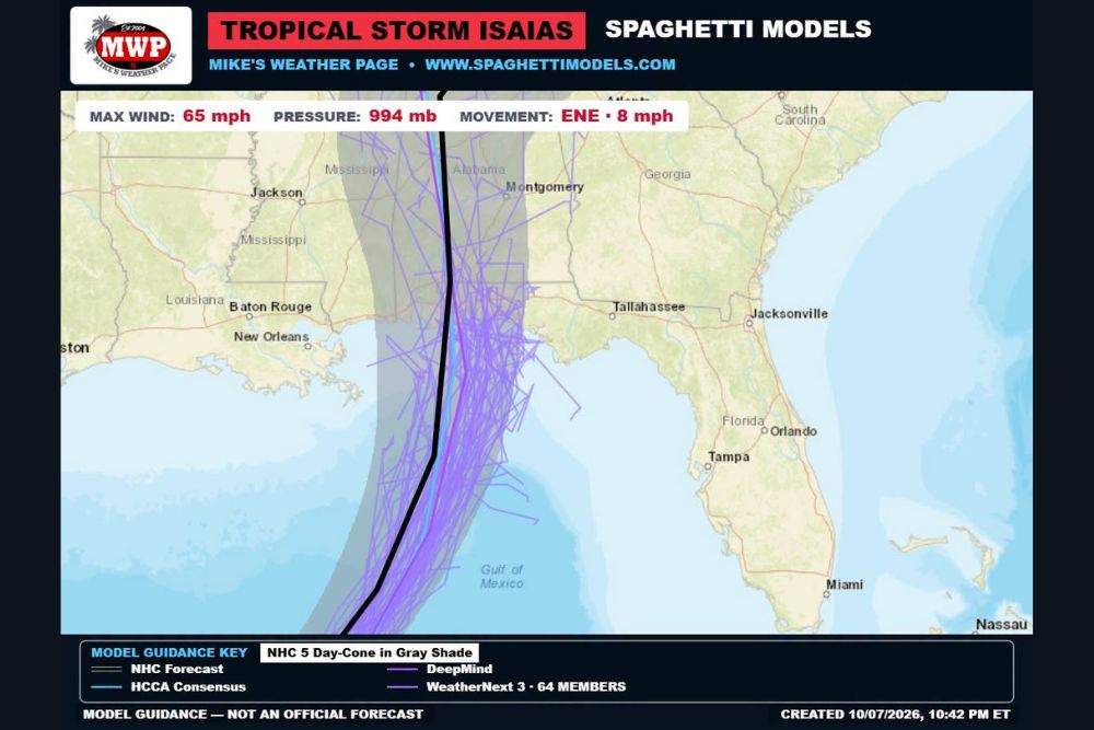
Gulf Coast – As Tropical Storm Isaias continues to organize in the Gulf, forecasters are paying close attention to how different computer models are handling its future track. The latest model guidance shows the National Hurricane Center’s forecast track lining up closely with two of the best-performing tools in recent years: Google DeepMind’s AI weather model and its ensembles, along with the HCCA consensus model. Both point toward a track bringing Isaias north toward the Alabama and western Florida Panhandle coast before moving inland.
Isaias Gaining Strength
At the time of the model run late Wednesday evening, October 7, Isaias had maximum sustained winds of 65 mph, a central pressure of 994 millibars, and was moving east-northeast at 8 mph. A later update from the National Hurricane Center showed the storm strengthening further, with winds reaching 70 mph, and forecasters expect Isaias to become a hurricane soon, potentially reaching Category 2 strength before landfall.
What the Model Guidance Shows
The latest spaghetti model plot shows the National Hurricane Center’s forecast track curving north through the central Gulf before reaching the coast near the Alabama and Florida Panhandle area. From there, the track continues north into southern and central Alabama, passing west of Montgomery.
The five-day forecast cone stretches from near the Mississippi coast east toward the central Florida Panhandle, covering cities such as Gulfport, Biloxi, Mobile, Gulf Shores, Pensacola, Destin, and Panama City.
Google DeepMind’s AI Model Performing Well
One of the most closely watched tools this season is Google DeepMind’s AI weather model, along with its group of 64 ensemble members. Ensembles run many slightly different versions of the same forecast to show a range of possible outcomes.
Last year, this AI model was the top-performing model for tropical forecasts, and it has also been doing well this season. Most of its ensemble members show Isaias tracking north toward the northern Gulf Coast, with landfall focused between coastal Alabama and the western Florida Panhandle, though a few members lean slightly farther east toward the central Panhandle.
HCCA Consensus Also Closely Aligned
The HCCA, or Hurricane Center Corrected Consensus Approach, is another important tool used by forecasters. It blends several top-performing models and adjusts for their known biases. The HCCA has been very reliable in prior years, and its forecast track for Isaias closely matches both the AI guidance and the official forecast.
National Hurricane Center Going Against the European Model
The National Hurricane Center’s forecast has stayed close to the AI model and HCCA consensus. That is part of the reason the official forecast has differed from the European model, which is often considered one of the most trusted weather models in the world.
Earlier this week, the European model kept Isaias in the southwestern Gulf for a longer period, while other guidance brought it north more quickly. The strong performance of the AI model and the HCCA consensus in recent seasons helped give forecasters more confidence in the northward track.
Possible Shift Slightly East
Forecasters will be watching to see if the official forecast shifts slightly east in upcoming updates, as some model members lean that direction. However, the overall thinking is that the next forecast will stay close to the current track.
Even small shifts can make a big difference for coastal communities. The strongest winds and highest storm surge typically occur just east of where the center makes landfall, so residents across the entire cone should stay alert.
Models Are Tools, Not Final Forecasts
It is important to remember that computer models are guidance, not official forecasts. The National Hurricane Center considers many models, satellite data, Hurricane Hunter observations, and forecaster experience before issuing its official track and intensity forecasts. Residents should always rely on the official forecast and guidance from local officials when making decisions.
Prepare Across the Entire Cone
Anyone living within the forecast cone, from Mississippi to the Florida Panhandle, should be preparing now. That includes stocking up on water, food, medications, flashlights, batteries, and phone chargers, securing outdoor items, and reviewing evacuation plans.
Residents should also remember that impacts from a hurricane, including heavy rain, flooding, storm surge, and strong winds, often extend well outside the cone.
Inland Impacts Expected
As Isaias moves inland, it is expected to weaken but could still bring gusty winds, heavy rain, downed trees, and power outages across Alabama, Mississippi, and parts of Tennessee over the weekend.
Stay Tuned for Updates
With Isaias strengthening and moving closer to the coast, forecasts will continue to be updated. Residents should check for the latest information from the National Hurricane Center and local emergency officials.
For more Gulf Coast tropical updates and hurricane coverage, stay with bchssreport.com.