
Heavy Rain Threat Increasing for Northeast Ohio and the Region on Sunday as Models Show a Swath of 1 to 2 Inches and Possible Thunderstorms
Cleveland, Ohio – Sunday is trending wet across Ohio and the surrounding region. Confidence continues to grow that parts of the area could see a period of moderate to potentially heavy rain sometime between early Sunday morning and Sunday evening. The latest high-resolution forecast models are showing a fairly impressive swath of rain, with some solutions bringing widespread totals of 1 to 2 inches to portions of the region. If the timing and track line up just right, a few thunderstorms could also be in the mix.
A Soaking Rain Looks Increasingly Likely
The main message for now is simple: Sunday is looking wet, and the chance for a soaking rainfall is increasing. After a mostly dry and pleasant stretch of weather, many communities could see their heaviest rain in quite some time.
What the Models Are Showing
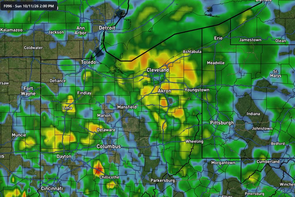
High-resolution model guidance for Sunday afternoon, October 11, shows widespread rain stretching across northern and central Ohio, western Pennsylvania, and parts of West Virginia and southeastern Michigan.
Some of the heaviest rain in the simulations is focused across Northeast Ohio, including areas near Cleveland, Akron, Youngstown, and Ashtabula, as well as stretches along the Lake Erie shoreline. Heavier pockets of rain also show up farther south and west near Lima, Delaware, Mansfield, and Chillicothe.
Rain is also expected to spread across Toledo, Findlay, Columbus, Dayton, and Cincinnati, along with Pittsburgh, Wheeling, Erie, and Meadville in Pennsylvania and Detroit in Michigan.
How Much Rain Could Fall?
Some model solutions show widespread totals of 1 to 2 inches across portions of the region. That is a significant amount of rain for a single day and could lead to ponding on roads, rising creeks and streams, and localized flooding in low-lying and poor drainage areas.
Areas that see repeated rounds of heavier rain could end up with even higher totals.
Placement Still Not Locked In
The exact location of the heaviest rain is still uncertain. A lot will depend on the track and timing of the low-pressure system moving through the region. Even a small shift in the storm’s path could make a big difference in which communities see the highest totals.
Forecasters will be watching the track closely over the next few days, and the forecast will likely be adjusted as Sunday gets closer.
Thunderstorms Possible Too
There is another wrinkle in the forecast. If the timing and track of the low-pressure system line up just right, there could be enough energy for a few thunderstorms to develop on Sunday. Thunderstorms could bring heavier downpours, lightning, and gusty winds, which would increase the risk for localized flooding.
At this point, severe weather is not the main concern, but thunderstorms cannot be ruled out.
Impact on Sunday Plans
With rain expected for much of the day, outdoor plans on Sunday may be affected. That includes football watch parties, fall festivals, pumpkin patches, and youth sports. Anyone heading out should bring rain gear and keep an eye on the radar.
Fans heading to Cleveland Browns or Pittsburgh Steelers games or tailgates should be prepared for wet conditions.
Driving Safety in Heavy Rain
Heavy rain can make roads slick and reduce visibility, especially on busy highways like I-71, I-77, I-80, I-90, and I-480. Wet leaves on roads can also make driving more dangerous in the fall.
Drivers should slow down, turn on headlights, and leave extra space between vehicles. Anyone who comes across a flooded road should turn around rather than trying to drive through it.
Prepare Before the Rain
Before Sunday, residents may want to clear gutters, downspouts, and storm drains, especially with leaves starting to fall. Clogged drains can quickly lead to street flooding during heavy rain. Moving outdoor furniture and decorations to sheltered areas can also help prevent damage.
Good News for Dry Areas
While the rain could cause some inconvenience, it would also be beneficial for lawns, gardens, and farmland after a dry stretch. A soaking rain could help improve soil moisture heading deeper into the fall season.
Stay Tuned for Updates
With the heaviest rain placement still uncertain, residents across Ohio and western Pennsylvania should keep checking for updates as Sunday approaches.
For more Ohio weather updates and local forecasts, stay with bchssreport.com.