
Tropical Storm Isaias Strengthens to 70 MPH and Is Forecast to Become a Category 2 Hurricane Before Landfall Between Mobile and Pensacola, With Impacts Reaching North Alabama Saturday
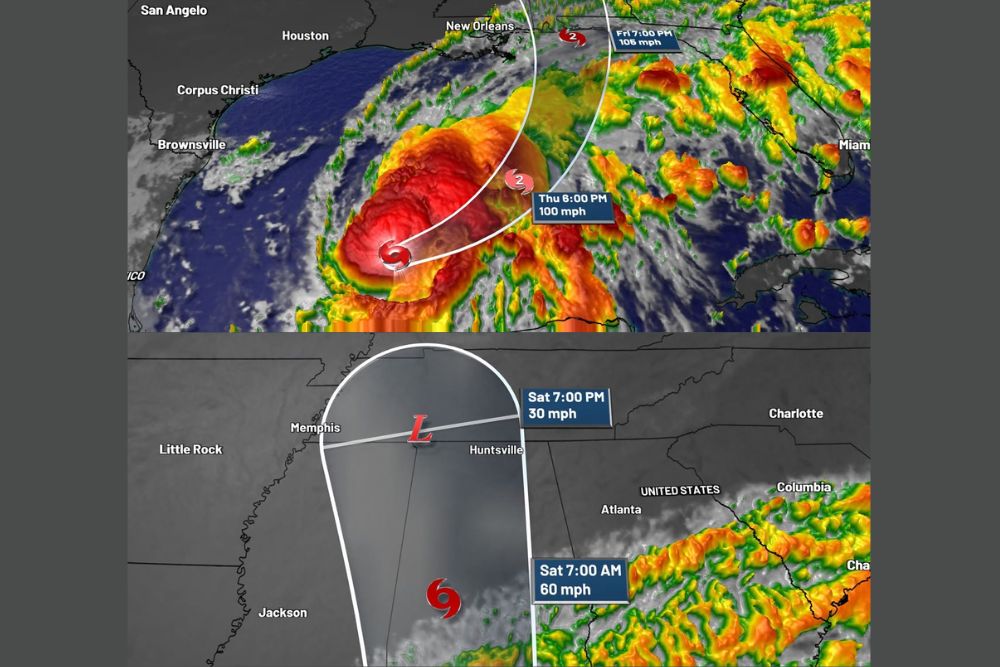
North Alabama – Tropical Storm Isaias is gaining strength in the Gulf, and forecasters now expect it to become a hurricane overnight. As of the 10 p.m. Wednesday update from the National Hurricane Center, Isaias had maximum sustained winds of 70 mph, a central pressure of 988 millibars, and was moving east-northeast at 9 mph. The storm is forecast to strengthen into a Category 2 hurricane by Thursday evening, with landfall expected somewhere between Mobile, Alabama, and Pensacola, Florida. The latest forecast track also shifted slightly to the northwest, bringing northwest Alabama into the path of the weakening storm late Saturday.
Rapid Strengthening Expected
Isaias is expected to become a hurricane overnight, with winds increasing to over 100 mph during the next 48 hours. By Thursday at 6 p.m., the forecast calls for the storm to be a Category 2 hurricane with winds near 100 mph as it moves across the central Gulf.
By Friday at 7 p.m., Isaias is forecast to be near the northern Gulf Coast with winds around 105 mph, keeping it at Category 2 strength as it approaches landfall.
Landfall Between Mobile and Pensacola
The current forecast places landfall between Mobile, Alabama, and Pensacola, Florida. That area includes Mobile Bay, Dauphin Island, Gulf Shores, Orange Beach, Perdido Key, and Pensacola Beach.
Residents in coastal Alabama and the western Florida Panhandle should be preparing now for hurricane-force winds, dangerous storm surge, heavy rain, and flooding. Areas just east of where the center makes landfall typically see the strongest winds and highest storm surge.
Weakening Quickly After Landfall
Once Isaias moves inland, it is expected to weaken quickly. By Saturday at 7 a.m., the storm is forecast to be over southern Mississippi and Alabama with winds near 60 mph, making it a tropical storm again.
By Saturday at 7 p.m., Isaias is expected to weaken further into a tropical depression, with winds around 30 mph, as it moves into northern Mississippi and northwest Alabama, between Memphis and Huntsville.
Tree Damage and Power Outages Inland
Even though Isaias will weaken after landfall, tree damage and power outages are expected several miles inland as the storm accelerates northward. Faster-moving storms can carry stronger winds farther inland before they weaken, which can bring down trees and power lines well away from the coast.
Communities across south and central Alabama and southern Mississippi should prepare for the possibility of downed trees, blocked roads, and power outages that could last for some time.
Impacts for North Alabama and Southern Middle Tennessee
For North Alabama and southern Middle Tennessee, impacts from Isaias are expected to begin on Saturday. Wind gusts of 30 to 45 mph could start reaching parts of the area just before noon Saturday.
These strong winds will come along with locally heavy rain bands, and rainfall totals of 1 to 3 inches are possible across the region. Gusty winds combined with rain-soaked ground could lead to scattered tree damage and isolated power outages.
Cooler Temperatures May Limit Severe Storms
Temperatures in North Alabama are expected to fall into the middle 60s late Saturday morning as the rain moves in. These cooler temperatures should help keep the threat for severe storms and isolated tornadoes away from North Alabama, since tropical systems usually need warm, unstable air to produce tornadoes.
However, forecasters will continue to monitor the situation closely, as the track and timing could still change.
Storm Pulls Away Early Sunday
Isaias is expected to pull away from the region early Sunday, allowing conditions to gradually improve. Rain and wind should taper off, though cleanup from any downed trees or power outages could continue into the day.
Prepare Now Along the Coast
Residents along the Alabama and Florida Panhandle coasts should finish hurricane preparations as soon as possible. That includes securing outdoor items, stocking up on water, non-perishable food, medications, batteries, and flashlights, and making sure phones and backup chargers are fully charged.
Anyone in an evacuation zone should follow instructions from local officials and leave if told to do so. Storm surge is often the deadliest part of a hurricane, and it is important not to wait until conditions worsen to evacuate.
Inland Residents Should Also Get Ready
People living inland, including in North Alabama and southern Middle Tennessee, should also prepare. Secure loose outdoor items, charge devices, and have flashlights ready in case of power outages. Avoid parking under large trees if possible, and never drive through flooded roads.
Continue Checking for Updates
Isaias is a strengthening storm, and forecasts may change as it approaches the coast. Residents across the Gulf Coast and inland Southeast should continue checking for updates from the National Hurricane Center and local officials.
For more Alabama and Gulf Coast tropical updates, stay with bchssreport.com.