Southwest Colorado and the Four Corners Placed Under Moderate Risk for Flash Flooding Sunday as Excessive Rainfall Threat Spreads Across Arizona, Utah and New Mexico
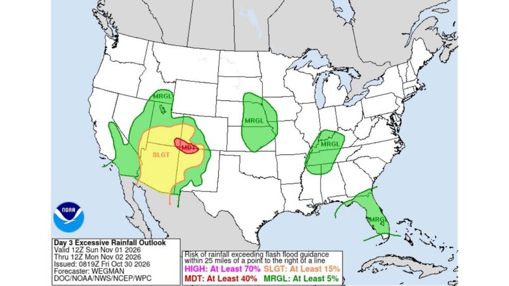
FOUR CORNERS — A Moderate Risk for excessive rainfall and flash flooding has been issued for part of the Four Corners region, centered on southwest Colorado, for Sunday, November 1, into Monday morning, November 2.
A broader Slight Risk stretches across much of Arizona, southern Utah and northwest New Mexico, while smaller Marginal Risk areas are highlighted in the central Plains, the Tennessee Valley and Florida.
Outlook Window: Sunday Morning Through Monday Morning
The Day 3 Excessive Rainfall Outlook from the Weather Prediction Center covers the period from 12Z Sunday, November 1, through 12Z Monday, November 2. It was issued early Friday, October 30, by forecaster Wegman.
What Each Risk Level Means
| Risk Level | Chance of Flash-Flood-Producing Rain Within 25 Miles |
|---|---|
| High | At least 70% |
| Moderate | At least 40% |
| Slight | At least 15% |
| Marginal | At least 5% |
Moderate Risk Centered on Southwest Colorado
The highest risk on the map, a Moderate Risk, sits over southwest Colorado near the Four Corners, close to the New Mexico border. This lines up with the high country of the San Juan Mountains, where a significant storm is also expected to bring heavy mountain snow at higher elevations.
At lower and middle elevations, heavy rain could lead to flash flooding in canyons, burn scars and narrow drainages.
Slight Risk Covers Much of Arizona, Southern Utah and Northwest New Mexico
A large Slight Risk area surrounds the moderate zone, covering:
- Most of Arizona
- Southern Utah
- Southwest Colorado
- Northwest New Mexico
This region could see scattered flash flooding where heavier rain bands set up.
Marginal Risk Across the Desert Southwest and Great Basin
An even wider Marginal Risk extends around the slight risk area, reaching into:
- Southeast California, including desert areas
- Southern Nevada
- Much of Utah
- Western Colorado and western New Mexico
Marginal Risk in the Central Plains
A separate Marginal Risk is highlighted over parts of the central Plains, covering eastern Nebraska and nearby areas of Kansas, where locally heavy rain could cause isolated flooding.
Marginal Risk Across the Tennessee Valley
Another Marginal Risk covers parts of:
- Western Kentucky
- Tennessee
- Northern Mississippi and Alabama
Florida Also Included in a Marginal Risk
Much of the Florida Peninsula is also under a Marginal Risk, tied to the expected heavy rain with an upper-level low that could stall over the state late Sunday into Monday.
Why the Four Corners Is at Higher Risk
The Four Corners region is especially vulnerable to flash flooding because of:
- Steep terrain and slot canyons
- Dry, rocky soils that do not absorb water well
- Burn scars that can turn rain into fast-moving debris flows
Flash Flood Safety Tips
- Avoid canyons, washes and slot canyons during heavy rain
- Never drive through flooded roads
- Move to higher ground if water begins rising
- Keep weather alerts on for any flash flood warnings
Outlook: Risk Areas Could Be Adjusted
Because this is a Day 3 outlook, risk levels and boundaries may change. Residents across the Southwest, central Plains, Tennessee Valley and Florida should watch for updates over the weekend.
Stay with Bchssreport.com for the latest updates on this story.
About The Author
