Pearl River County, Mississippi Hit With Up to 17 Inches of Rain Overnight as Storm Stalls for Hours Over Tiny Area Near Bogalusa, Prompting Flash Flood Warnings
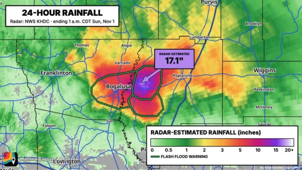
POPLARVILLE, MISSISSIPPI — A shocking rainfall event unfolded Saturday night in Pearl River County, Mississippi, where a single storm stalled for hours over a small area and dumped as much as 17.1 inches of rain, according to radar estimates.
The extreme totals came even though the forecast had only called for widely scattered thunderstorms with a “marginal” flood risk.
Radar Estimates 17.1 Inches in 24 Hours
The 24-hour rainfall estimate, ending at 1 a.m. CDT Sunday, November 1, 2026, came from the National Weather Service KHDC radar.
| Detail | Information |
|---|---|
| Peak Radar-Estimated Rainfall | 17.1 inches |
| Location | Pearl River County, Mississippi, east of Bogalusa |
| Period | 24 hours ending 1 a.m. CDT Sunday, November 1 |
| Original Forecast | Widely scattered storms, marginal flood risk |
A Tiny Area Stuck Under a Downpour for Hours
What made this event so extreme was the storm’s lack of movement. Instead of passing through, it stayed parked over a very small area for hours, sending rainfall totals soaring far beyond what anyone expected.
Heaviest Rain Between Bogalusa and Poplarville
The highest totals were centered just east of Bogalusa, Louisiana, across the state line in Pearl River County, west of Poplarville.
Rainfall zones around the bullseye included:
| Area | Approximate Radar-Estimated Rainfall |
|---|---|
| Core of the storm, Pearl River County | 15 to 17+ inches |
| Area around Bogalusa | 5 to 10+ inches |
| Near Varnado and Angie | About 3 to 5 inches |
| Near Poplarville | About 3 to 5 inches |
| Lumberton, Purvis and Wiggins areas | About 1 to 3 inches |
Flash Flood Warnings Issued for the Hardest-Hit Areas
Flash flood warnings were issued for the zone where rain kept piling up, covering:
- Bogalusa and nearby areas of Washington Parish, Louisiana
- The western part of Pearl River County, Mississippi
- Areas just south toward the Mississippi and Louisiana border
Nearby Communities Saw Much Less
The storm’s narrow footprint meant towns just miles away saw far lower totals. Places like Franklinton, Folsom, Covington, Perkinston, McHenry and Brooklyn recorded light to moderate rain, often 2 inches or less.
Why “Marginal” Risk Days Can Still Bring Extreme Flooding
A marginal flood risk means flooding is expected to be isolated. But as this event shows, isolated does not mean minor. When one storm stalls over the same spot, even a low-risk day can produce devastating local flooding.
Possible Impacts From 17 Inches of Rain
Rainfall this extreme in such a short time can lead to:
- Rapid flooding of roads, yards and homes
- Creeks and streams overflowing their banks
- Washed-out roads and damaged culverts
- Water rescues in the hardest-hit spots
Officials have not yet released details on damage or rescues from the event.
What to Do After a Major Flash Flood
- Avoid driving on roads that were underwater, as they may be damaged
- Stay away from floodwater, which can hide debris and hazards
- Check homes for water damage and document it for insurance
- Follow local officials for updates on road closures
A Reminder That Forecasts Can’t Catch Every Storm
Forecasters called it a locally crazy, unforeseen event, a reminder that even with modern tools, a single stalled storm can still surprise everyone.
Stay with Bchssreport.com for the latest updates on this story.
About The Author
