Colorado’s San Juan Mountains Under Winter Storm Warnings as Peaks Above 10,000 Feet Could Top 2 Feet of Snow Through Monday Morning
TELLURIDE, COLORADO — Winter Storm Warnings are in effect for the higher elevations of the San Juan Mountains in southwest Colorado, where areas above 10,000 feet have a medium to high chance of picking up more than two feet of snow through Monday, November 2, 2026.
At lower elevations, rain is expected to change to snow going into Monday, with slushy accumulations possible as low as 7,500 to 8,500 feet.
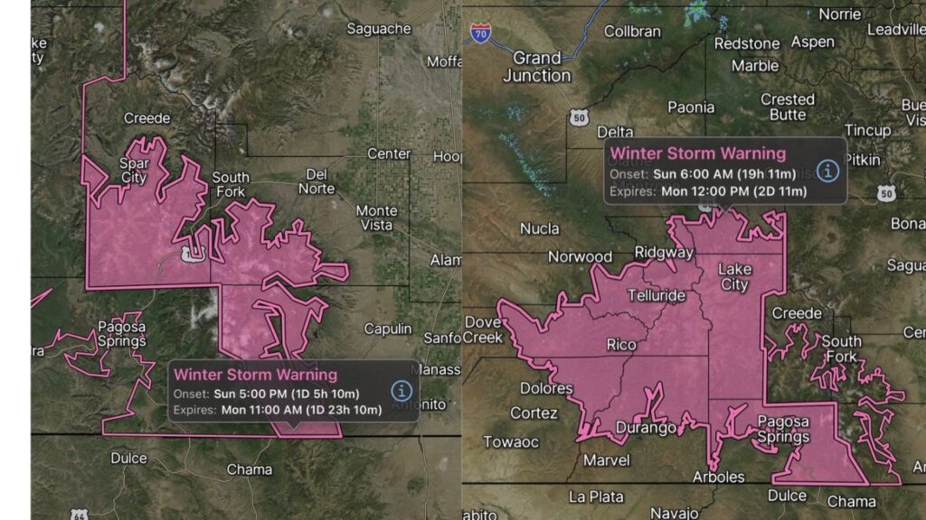
Two Winter Storm Warnings in Effect
| Warning Area | Starts | Ends |
|---|---|---|
| Western and central San Juans | 6 a.m. Sunday, November 1 | 12 p.m. Monday, November 2 |
| Eastern San Juans | 5 p.m. Sunday, November 1 | 11 a.m. Monday, November 2 |
Western and Central San Juans: Telluride to Durango and Lake City
The first warning covers the high country of the western and central San Juans, including mountain terrain near:
- Telluride and Ridgway
- Rico
- Lake City
- North of Durango
- High terrain near Pagosa Springs
This warning began at 6 a.m. Sunday and runs through noon Monday.
Eastern San Juans: Creede, South Fork and the Wolf Creek Area
The second warning covers the eastern San Juans, including high terrain near:
- Creede and Spar City
- South Fork
- West of Del Norte
- Mountains north of Pagosa Springs
This warning starts at 5 p.m. Sunday and lasts until 11 a.m. Monday.
More Than 2 Feet of Snow Likely Above 10,000 Feet
Forecasters say there is a medium to high probability that elevations above 10,000 feet will see more than 24 inches of snow by Monday. This lines up with earlier forecasts calling for 1 to 2 feet across the high peaks.
Rain Turns to Slushy Snow Down to 7,500 to 8,500 Feet
As colder air moves in going into Monday, rain at lower elevations is expected to switch to snow. That could bring slushy accumulations to areas as low as 7,500 to 8,500 feet, which may affect some mountain towns and lower passes.
Same Storm Bringing Major Flood Threat to the Region
This winter storm is part of the same atmospheric river system that is driving a serious flash flood threat across Arizona, Utah and southwest Colorado today. While higher elevations get heavy snow, lower areas of the San Juans face the risk of flash flooding, possibly rivaling last week’s flooding.
Travel Impacts on Mountain Highways and Passes
Drivers should expect difficult to dangerous travel on high mountain routes, including:
- U.S. 550 between Durango, Silverton and Ouray
- U.S. 160 over Wolf Creek Pass
- Colorado 145 near Telluride and Rico
- Colorado 149 near Creede and Lake City
Expect snow-packed roads, low visibility, possible chain laws and temporary closures.
Good News for Colorado Ski Areas
The heavy high-elevation snow could give Wolf Creek and other ski areas a major boost toward opening day in the coming week.
Winter Travel Safety Tips
- Delay mountain travel during the heaviest snow if possible
- Carry chains, blankets, food and water
- Check road conditions before leaving
- Keep your gas tank full in case of delays
Stay with Bchssreport.com for the latest updates on this story.
About The Author
