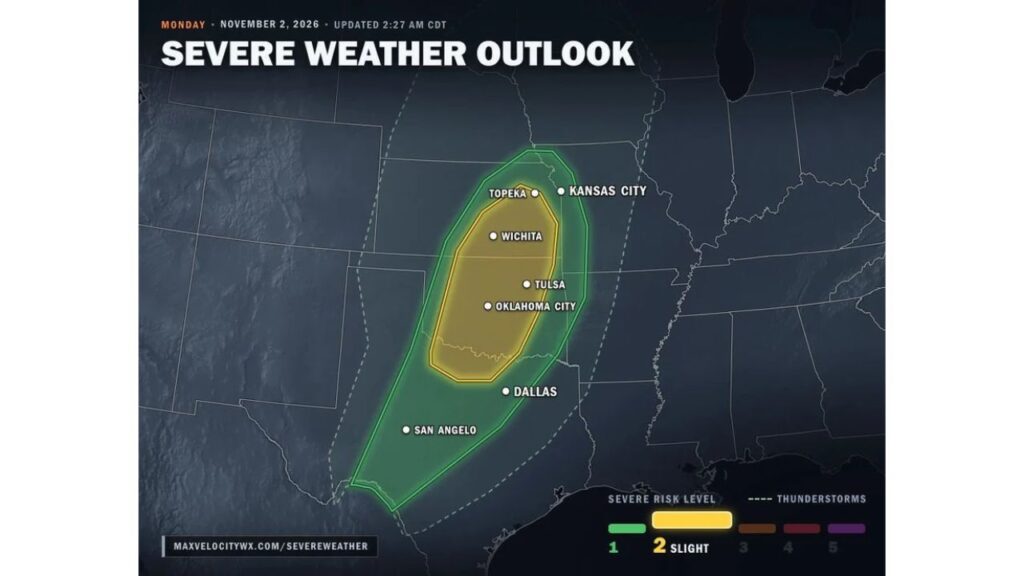
Oklahoma, Southeast Kansas and North Texas Under Slight Risk for Damaging Winds and Possible Tornadoes Monday Evening as Dryline Storms Fire Around 6 p.m.
TULSA, OKLAHOMA — Damaging winds and possibly a tornado or two are expected Monday evening, November 2, 2026, from western Oklahoma into southeast Kansas and North Texas, including the Oklahoma City, Tulsa and Wichita areas.
Outlook Updated Early Monday Morning
The severe weather outlook was updated at 2:27 a.m. CDT Monday and shows two main risk levels across the southern and central Plains.
Level 2 Slight Risk: Oklahoma City, Tulsa, Wichita and Topeka
The Level 2 (Slight) Risk covers:
| State | Cities in Slight Risk |
|---|---|
| Oklahoma | Oklahoma City, Tulsa |
| Kansas | Wichita, Topeka |
This zone includes most of Oklahoma from the Red River north, along with south-central and eastern Kansas.
Level 1 Marginal Risk: Kansas City, Dallas and San Angelo
A wider Level 1 (Marginal) Risk surrounds the slight risk area, reaching:
- Kansas City and western Missouri
- Dallas and North Texas
- San Angelo and west-central Texas
- A long stretch south toward South Texas
Outside that, a broader thunderstorm area covers much of the central U.S., where non-severe storms are possible.
Quiet Day Before Storms Fire at Sunset
Thick clouds are expected to keep most of Monday daytime largely storm-free. That changes in the evening.
Storms Develop Along the Dryline in Western Oklahoma Around 6 p.m.
A strong storm system moving into the Plains will set off storms along a dryline in western Oklahoma at about 6 p.m. From there, storms are expected to spread east across:
- Oklahoma
- Eastern Kansas
- North Texas
Storm Timeline Monday Evening
| Time | What to Expect |
|---|---|
| Daytime | Mostly storm-free under thick clouds |
| Around 6 p.m. | Storms develop along the dryline in western Oklahoma |
| 6 p.m. to midnight | Highest tornado risk as storms move east |
| Through the evening | Storms spread across Oklahoma, eastern Kansas and North Texas |
Main Threat: Damaging Winds
Damaging winds are the primary concern with Monday evening’s storms. Strong gusts could bring down trees, power lines and damage roofs and outbuildings.
Tornado Risk Highest Between 6 p.m. and Midnight
Because some wind shear is present near the ground, a few storms could rotate. The highest tornado risk is between 6 p.m. and midnight, when storms are first developing and moving east.
Overnight Storms Raise Safety Concerns
With storms arriving after dark, many people may be at home or asleep when warnings are issued. That makes having reliable alerts especially important.
How to Prepare Before Monday Evening
- Know your safe place, such as a basement or interior room on the lowest floor
- Set phone alerts to loud and keep a weather radio nearby
- Charge devices in case of power outages
- Secure outdoor items before winds pick up
- Avoid unnecessary travel during the storms
Storms Shift East on Tuesday
As the system keeps moving, storms are expected to shift into East Texas, Arkansas, Louisiana and Mississippi on Tuesday, where damaging winds will also be possible.
Outlook: Watch for Updates Throughout Monday
The risk area could still be adjusted as Monday goes on. Residents across Oklahoma, Kansas and North Texas should keep checking for watches and warnings into the evening.
Stay with Bchssreport.com for the latest updates on this story.
About The Author
