Florida Rain Totals Through Monday Could Reach 3 to 4 Inches in Spots Around Tampa Bay and the East-Central Coast as Nearly the Entire State Gets in on the Rain
TAMPA, FLORIDA — Nearly all of Florida is in line for some rain through Monday, November 2, 2026, with a few areas potentially picking up 3 to 4 inches as an upper-level low sets up over the state.
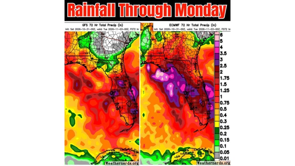
Forecast maps from two major global computer models show how totals could vary, with some spots getting much more rain and others getting less.
Forecast Window: Saturday Night Through Monday Evening
The rain totals cover a 72-hour period from Saturday evening, October 31, through Monday evening, November 2.
Statewide Picture: Rain for Nearly Everyone
Both forecasts agree that most of Florida gets measurable rain, with the heaviest amounts centered on Central Florida, the Tampa Bay region and the east-central coast.
Heaviest Totals: Tampa Bay and the East-Central Coast
| Area | Forecast Rainfall Range |
|---|---|
| Tampa Bay and nearby Gulf coast | About 2.5 to 5 inches in spots |
| East-central Florida coast | About 2.5 to 4+ inches in spots |
| Interior Central Florida | About 1.25 to 2.5 inches |
| Southeast Florida coast | About 1.5 to 3 inches |
| South Florida and the Keys | About 1 to 2 inches |
One forecast shows a concentrated pocket near Tampa Bay approaching 5 inches, while the other shows its heaviest amounts closer to 3 to 4 inches along the east-central coast.
Heaviest Rain Offshore in the Gulf
One of the forecasts places a large area of 3 to 6 inches just offshore in the eastern Gulf of Mexico, west of the Florida Peninsula. If that band shifts slightly east, coastal areas could see higher totals.
North Florida and the Panhandle: The Biggest Difference Between Forecasts
The two forecasts disagree most over North Florida and the Panhandle:
| Area | Forecast One | Forecast Two |
|---|---|---|
| North Florida | About 0.1 to 0.6 inches | About 0.5 to 1.5 inches |
| Florida Panhandle | Mostly under 0.5 inch | About 0.5 to 1.5 inches |
| Southern Georgia | Mostly dry | About 0.5 to 1 inch |
That means rain in North Florida could range from light showers to a solid soaking, depending on how the system evolves.
Why Totals Could Vary So Much
Official rain maps often blend different forecast ideas into a smoother picture. Looking at individual model runs shows how isolated areas could get more or less than the official forecast.
With an upper-level low and a weak surface low in place, rain could fall in bands, meaning one neighborhood may get several inches while another a few miles away gets much less.
Possible Impacts Across Florida
Where the heaviest rain sets up, residents could see:
- Street flooding in low-lying and poorly drained areas
- Slow travel during heavy downpours
- Ponding on highways, especially during the Monday morning commute
- Gusty winds with stronger bands
Rain Tied to Upper-Level Low Over Florida
This rain is linked to the upper-level low expected to briefly stall over Florida late Sunday into Monday, along with a front and converging winds that could focus heavy rain over Central Florida.
Safety Tips for a Wet Start to the Week
- Avoid driving through flooded roads
- Allow extra time for Monday’s commute
- Clear storm drains near your home
- Keep weather alerts on for any flood advisories
Outlook: Some Will Get More, Some Will Get Less
Forecasters stress that rainfall will be uneven, so some areas may end up with far less than expected, while others could be surprised by heavier totals.
Stay with Bchssreport.com for the latest updates on this story.
About The Author
