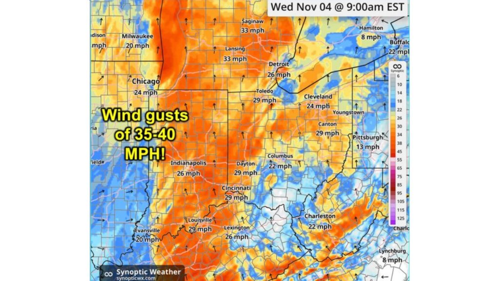
Ohio Valley and Great Lakes Wake Up to a Windy Wednesday as Gusts of 35 to 40 MPH Sweep Through Michigan, Indiana and Ohio Behind a Cold Front
INDIANAPOLIS, INDIANA — A windy Wednesday morning, November 4, 2026, is underway across parts of the Ohio Valley and Great Lakes, where non-thunderstorm wind gusts of 35 to 40 mph are possible behind a passing cold front.
Why It’s So Windy
The strong winds are coming behind a cold front that moved through the region. As colder air rushes in, it creates a sharp pressure difference, driving gusty winds even without any thunderstorms.
Forecast Wind Gusts at 9 a.m. EST Wednesday
| City | Forecast Gust |
|---|---|
| Saginaw, Michigan | 33 mph |
| Lansing, Michigan | 33 mph |
| Toledo, Ohio | 29 mph |
| Canton, Ohio | 29 mph |
| Dayton, Ohio | 29 mph |
| Cincinnati, Ohio | 29 mph |
| Louisville, Kentucky | 29 mph |
| Detroit, Michigan | 26 mph |
| Indianapolis, Indiana | 26 mph |
| Lexington, Kentucky | 26 mph |
| Chicago, Illinois | 24 mph |
| Cleveland, Ohio | 24 mph |
| Columbus, Ohio | 22 mph |
| Charleston, West Virginia | 22 mph |
| Buffalo, New York | 22 mph |
| Milwaukee, Wisconsin | 20 mph |
| Pittsburgh, Pennsylvania | 13 mph |
| Evansville, Indiana | 13 mph |
| Hamilton, Ontario | 8 mph |
| Lynchburg, Virginia | 8 mph |
Strongest Gusts of 35 to 40 MPH Across Indiana and Michigan
The orange shading on the forecast map, showing the strongest gusts, stretches across much of Indiana, western and central Ohio and southern Michigan. Within that zone, isolated gusts of 35 to 40 mph are possible.
Michigan’s Saginaw and Lansing Among the Windiest Cities
Saginaw and Lansing lead the city forecasts with gusts near 33 mph, while Detroit is expected to see gusts around 26 mph.
Ohio Valley Cities Also Feeling the Wind
Gusts around 29 mph are forecast for Cincinnati, Dayton, Louisville and Canton, with Indianapolis and Lexington near 26 mph.
Calmer Conditions to the East
Winds ease farther east. Pittsburgh is forecast near 13 mph, while areas like Lynchburg and Hamilton stay much calmer at around 8 mph.
Possible Impacts From Strong Gusts
Gusts of 35 to 40 mph can cause:
- Falling tree limbs, especially those weakened by fall leaves
- Scattered power outages
- Blown-over trash cans and lawn decorations
- Difficult driving for trucks, RVs and high-profile vehicles
Leaves and Debris on the Move
With many trees dropping their leaves this time of year, strong winds could send leaves and small debris flying across roads, reducing visibility and making surfaces slick in spots.
Safety Tips for a Windy Day
- Secure outdoor items like patio furniture and decorations
- Keep both hands on the wheel while driving
- Watch for downed branches on roads and sidewalks
- Avoid parking under large trees
- Charge devices in case of brief power outages
Colder Air Follows the Wind
The cold front driving today’s winds is part of a larger pattern bringing a major temperature drop across the region. By Saturday morning, temperatures could fall 30 to 40 degrees compared to earlier in the week, with frost likely.
Outlook: Winds Ease Later in the Day
Winds are expected to gradually calm later in the day as the front moves away, though breezy conditions could linger in some spots.
Stay with Bchssreport.com for the latest updates on this story.
About The Author
