Minnesota and Wisconsin Pelted by Hail Up to 2.24 Inches as Powerful Storms Carve Long Hail Tracks Near Minneapolis and St. Cloud Before Winding Down
MINNEAPOLIS, MINNESOTA — Powerful thunderstorms swept across Minnesota and Wisconsin on Wednesday, October 28, 2026, dropping hail from half an inch to more than 2 inches in diameter before finally winding down Wednesday night.
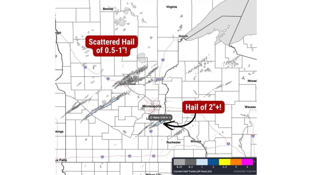
The largest hail on the map, measuring 2.24 inches, was tracked just south of the Minneapolis metro.
Hail Tracks Over the Past 24 Hours
Hail-tracking data covering the 24 hours ending at 10:30 p.m. on October 28 shows several long, narrow streaks of hail running from southwest to northeast across both states.
| Hail Size | Where It Was Tracked |
|---|---|
| 2 inches or larger (peak 2.24 in) | South of the Minneapolis metro |
| About 1 inch | Southwest of St. Cloud, and in streaks west and north of Minneapolis |
| 0.5 to 1 inch | Scattered across central and north-central Minnesota |
| About 0.25 to 0.5 inch | Northwestern Wisconsin and east-central Minnesota |
Largest Hail of the Day: 2.24 Inches South of Minneapolis
The biggest hailstone on the map came from a storm that tracked south of Minneapolis, near Interstate 35. A reading of 2.24 inches was recorded there.
Hail that size, larger than a hen’s egg, can dent cars, crack windshields, damage roofs and shatter windows.
Long Hail Streaks Near St. Cloud and West of the Twin Cities
Several long hail tracks stretched across central Minnesota:
- A streak running through the St. Cloud area toward the northeast
- A long band southwest of St. Cloud, near U.S. Highway 71, with hail up to about 1 inch
- Additional streaks north and west of Minneapolis
These narrow paths show how individual storms moved steadily northeast, dropping hail along the way.
Scattered Half-Inch to 1-Inch Hail Across Central and Northern Minnesota
Farther north, scattered hail of 0.5 to 1 inch was tracked across central and north-central Minnesota, including areas between Fargo and Bemidji and spots west of Duluth.
Northwestern Wisconsin Also Hit
Storms carried hail across the state line into northwestern Wisconsin, with tracks showing up south and east of Duluth and toward Rhinelander. Most of the hail there fell in the smaller size ranges.
Areas That Largely Escaped the Hail
Southern Minnesota near Rochester and Winona, along with southwest Minnesota and areas near Sioux Falls, saw little to no hail on the tracking map.
Storms Winding Down Wednesday Night
By late Wednesday, storms were weakening and winding down across both states, ending the threat of additional hail for the night.
What to Do After a Hailstorm
Residents in areas hit by hail should:
- Check vehicles for dents and cracked glass
- Inspect roofs, siding and gutters for damage
- Take photos of any damage for insurance claims
- Be cautious of contractors going door to door after storms
Late October Severe Weather Is a Rare Reminder
Large hail in late October is unusual for the Upper Midwest, serving as a reminder that severe storms can still develop well into fall when warm and unstable air meets a strong weather system.
Stay with Bchssreport.com for the latest updates on this story.
About The Author
