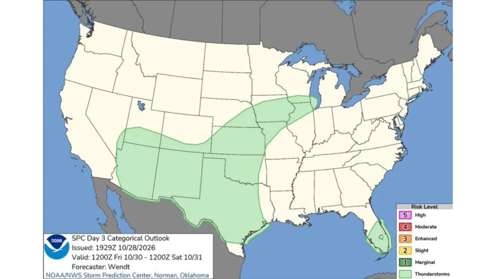
Arizona, New Mexico, Texas, Oklahoma, Kansas and Iowa Could See Thunderstorms Friday Into Halloween Morning, but No Severe Weather Risk Is Expected
OKLAHOMA CITY, OKLAHOMA — A wide swath of the Southwest, southern Plains and Midwest could hear rumbles of thunder from Friday morning, October 30, into Halloween morning, Saturday, October 31, according to the latest Day 3 outlook from the NOAA Storm Prediction Center.
The good news for weekend plans: no organized severe weather risk is currently highlighted anywhere in the country for this period.
Outlook Window: 7 a.m. CDT Friday Through 7 a.m. CDT Saturday
The outlook was issued at 2:30 p.m. CDT on Wednesday, October 28, and covers the 24-hour period from 7 a.m. CDT Friday, October 30, through 7 a.m. CDT Saturday, October 31. It was prepared by forecaster Wendt at the Storm Prediction Center in Norman, Oklahoma.
Main Thunderstorm Zone: From Arizona to Northern Illinois
The largest area of general thunderstorms stretches across a long corridor of the country:
| Region | States Included |
|---|---|
| Desert Southwest | Arizona, New Mexico |
| Four Corners | Southern Utah, southern Colorado |
| Southern Plains | Most of Texas, Oklahoma |
| Central Plains | Kansas, eastern Nebraska |
| Midwest | Missouri, Iowa, northern Illinois, southern Wisconsin |
| Gulf Coast | Upper Texas coast and a small part of southwest Louisiana |
South Florida Gets Its Own Pocket of Storms
A separate, smaller thunderstorm area covers South Florida, where warm and humid air could support scattered storms during the outlook period.
No Marginal, Slight or Higher Severe Risk on the Map
None of the highlighted areas reach even a Level 1 (Marginal) severe risk. The entire outlook falls under the general thunderstorm category, meaning storms are possible but not expected to be severe.
That means forecasters do not currently expect:
- Damaging winds of 58 mph or stronger
- Hail one inch or larger
- Tornadoes
Areas Expected to Stay Storm-Free
Much of the country is outside any thunderstorm area for this period, including:
- The West Coast and Pacific Northwest
- The Northern Rockies and Northern Plains
- The Great Lakes east of Illinois
- The Ohio Valley, Southeast outside South Florida and the Northeast
Halloween Morning Impacts
Since the outlook ends at 7 a.m. Saturday, it does not cover Halloween evening itself. Still, any storms lingering into early Saturday across the Plains and Midwest could leave behind wet roads and damp conditions as the holiday begins.
Why General Thunderstorms Still Matter
Even without a severe risk, thunderstorms can bring hazards:
- Lightning, which can be dangerous for anyone outdoors
- Brief heavy rain that can cause ponding on roads
- Gusty winds near the strongest storms
People with outdoor Friday night events, such as high school football games or fall festivals, should keep an eye on the sky.
Lightning Safety Reminders
- When thunder roars, go indoors
- Wait 30 minutes after the last thunder before heading back outside
- Avoid open fields, tall trees and metal objects during storms
Outlook Could Change in the Coming Days
Because this is a Day 3 forecast, the details could still shift. Updated outlooks on Thursday and Friday may adjust where storms develop or add a severe risk if conditions change.
Stay with Bchssreport.com for the latest updates on this story.
About The Author
