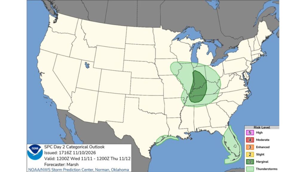
Lower Ohio and Western Tennessee Valleys Face Level 1 Severe Storm Risk on Veterans Day as Midweek Cold Front Sweeps Through Indiana, Illinois and Kentucky
EVANSVILLE, INDIANA — Parts of the lower Ohio Valley and western Tennessee Valley are under a Level 1 (Marginal) risk for severe thunderstorms on Wednesday, November 11, 2026, as a cold front pushes through the region on Veterans Day.
A much larger area of general thunderstorms covers a big chunk of the Midwest and South.
Outlook Details
| Detail | Information |
|---|---|
| Issued | 11:16 a.m. CST Tuesday, November 10 |
| Valid | 6 a.m. CST Wednesday through 6 a.m. CST Thursday, November 12 |
| Forecaster | Marsh, Storm Prediction Center, Norman, Oklahoma |
| Highest risk | Level 1 (Marginal) |
| Main area | Lower Ohio and western Tennessee Valleys |
Level 1 Risk Stretches From Indiana to Western Tennessee
The Marginal Risk area runs north to south through the heart of the region, covering parts of:
- Central and southwest Indiana, including areas near Evansville
- Southeast Illinois
- Western Kentucky
- Western and Middle Tennessee
- The far edge of northwest Mississippi and the Bootheel region
What a Level 1 Risk Means
A Marginal Risk means isolated severe storms are possible. These storms are usually limited in number or short-lived, but they can still bring:
- Isolated damaging wind gusts
- A brief tornado in stronger storms
- Heavy downpours
- Frequent lightning
General Thunderstorms Cover a Wide Area
Outside the marginal zone, general thunderstorms are possible across:
| Region | Areas Included |
|---|---|
| Midwest | Eastern Iowa, northern Missouri, Illinois, Indiana and western Ohio |
| Ohio Valley | Kentucky and southern Ohio |
| Mid-South | Tennessee, northern Mississippi, northern Alabama and northeast Arkansas |
| Gulf Coast | Upper Texas coast near Houston |
| Florida | Much of the Florida Peninsula |
Cold Front Brings Storms, Then a Cooldown
The storms are tied to a midweek cold front sweeping across the Corn Belt and Ohio Valley. Behind the front, temperatures are expected to drop toward or below normal by Thursday and Friday, with some of the coldest departures in the Tennessee Valley.
Veterans Day Plans Could Be Affected
With storms possible during the day on Veterans Day, people attending parades, ceremonies and other outdoor events in the Ohio and Tennessee Valleys should keep an eye on the sky and have a backup plan.
Coastal Texas and Florida Also See Storms
The upper Texas coast, including the Houston area, and much of Florida could see scattered thunderstorms as Gulf moisture lingers ahead of cooler air.
Severe Weather Safety Reminders
- Keep weather alerts on during the day and evening
- Know your safe place in case of a tornado warning
- Head indoors when thunder is heard
- Avoid driving through heavy downpours
- Secure outdoor items ahead of gusty winds
What Comes Next
Once the front passes, cooler and drier air will settle in across the Midwest, Ohio Valley and South, setting up a chilly end to the week and a possible coastal storm with mountain snow in the Northeast.
Outlook: Storms Exit by Thursday Morning
Storm chances are expected to wind down by early Thursday, as the front moves east and colder air takes over.
Stay with Bchssreport.com for the latest updates on this story.
About The Author
