Interior New England, Upstate New York and the Appalachians Could See First Accumulating Snow Late Next Week as Coastal Storm Taps Early-Season Cold
NORTHEAST — Could it snow in the Northeast late next week? Forecasters say yes, it’s possible. A storm likely tracking near the coast could run into just enough cold air to produce wet snow, especially away from the coast.
Because it is so early in the season and ocean waters are still warm, inland areas have the best chance of seeing at least an inch of snow.
Forecast Window: Friday Night Through Sunday Morning, November 15
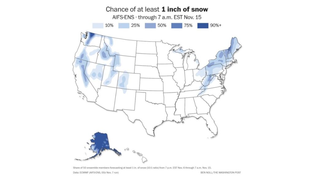
The snow chances come from a set of 50 ensemble forecast runs, showing the share of runs that produce at least 1 inch of snow between 7 p.m. EST Friday, November 6, and 7 a.m. EST Sunday, November 15, 2026.
Chances of at Least 1 Inch of Snow in the East
| Area | Chance of 1+ Inch of Snow |
|---|---|
| Interior Maine, northern New Hampshire and Vermont mountains | About 75 to 90%+ |
| Western Maryland and West Virginia mountains | About 50 to 75% |
| Upstate New York | About 25 to 50% |
| Interior Pennsylvania | About 10 to 50% |
| Northeast Ohio | About 10 to 25% |
| Virginia and North Carolina Appalachians | About 10 to 25% |
| Michigan’s Upper Peninsula | About 10 to 25% |
| I-95 cities like New York, Philadelphia and Boston | Low to no chance |
Why the Coast Is Less Likely to See Snow
Coastal areas face two big hurdles:
- Warm ocean waters keep air near the coast too mild for snow
- Early-season cold air is often not deep enough to reach the shoreline
That means cities along I-95 are more likely to see rain or a rain-snow mix, while higher, inland areas have the best shot at accumulation.
Wet, Heavy Snow Possible
If snow does fall, it is likely to be wet and heavy, the kind that can:
- Weigh down tree limbs, many still holding fall leaves
- Cause power outages
- Make roads slushy and slick, especially at night
Strong Snow Signal in the West and Alaska Too
Snow chances are also high in parts of the West:
| Area | Chance of 1+ Inch of Snow |
|---|---|
| Washington Cascades | 90%+ |
| Idaho and Montana Rockies | About 25 to 75% |
| Oregon Cascades | About 25 to 50% |
| Sierra Nevada | About 25 to 50% |
| Utah and Colorado mountains | About 10 to 25% |
| Alaska | 90%+ across much of the state |
Part of a Larger Pattern Change
This snow threat comes as the East shifts into a much colder pattern, with Canadian air diving south and a pool of very cold air over Quebec and Labrador. Forecasts also show first 50-degree highs in Washington, D.C., and a sharp cool-down reaching Florida.
Forecast Still Several Days Out
The storm is still about a week away, and its exact track will determine who sees snow. A track closer to the coast could bring more rain, while a track farther offshore could limit snow inland.
How to Prepare for Early-Season Snow
- Check snow tires and winter gear
- Trim weak tree branches near your home
- Have flashlights and batteries ready for outages
- Keep an eye on updated forecasts through the week
Stay with Bchssreport.com for the latest updates on this story.
About The Author
