Houston and the Middle to Upper Texas Coast Under Level 1 Severe Storm Risk Tuesday as Gulf Moisture Fuels Storms Along the Coastline
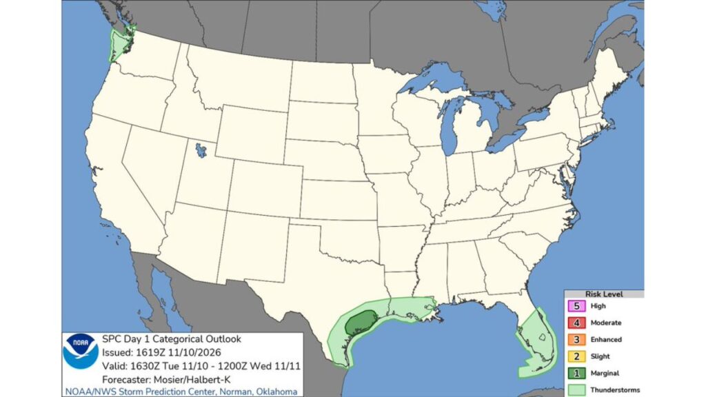
HOUSTON, TEXAS — Parts of the middle and upper Texas coast, including the Houston area, are under a Level 1 (Marginal) risk for severe thunderstorms on Tuesday, November 10, 2026, according to the NOAA Storm Prediction Center.
A broader area of general thunderstorms stretches along the Gulf Coast and across South Florida.
Outlook Details
| Detail | Information |
|---|---|
| Issued | 10:19 a.m. CST Tuesday, November 10 |
| Valid | 10:30 a.m. CST Tuesday through 6 a.m. CST Wednesday, November 11 |
| Forecasters | Mosier and Halbert-K, Storm Prediction Center, Norman, Oklahoma |
| Highest risk | Level 1 (Marginal) |
| Main area | Middle to upper Texas coast |
Level 1 Risk Centered on the Houston Area
The Marginal Risk covers a section of the upper Texas coast, centered on the Houston metro and nearby areas, including:
- Houston and its surrounding suburbs
- Areas southwest toward the Matagorda Bay region
- Coastal counties near Galveston Bay
What a Level 1 Marginal Risk Means
A Marginal Risk is the lowest severe category on the Storm Prediction Center’s five-level scale. It means isolated severe storms are possible, but they are expected to be limited in number, duration or intensity.
Possible hazards in a marginal risk area can include:
- Isolated damaging wind gusts
- A brief tornado in the strongest storms
- Heavy downpours and frequent lightning
General Thunderstorms Along the Gulf Coast
Outside the marginal risk zone, general thunderstorms are expected across a wider area:
| Region | Areas Included |
|---|---|
| South Texas coast | Corpus Christi area to the Rio Grande Valley |
| Louisiana coast | Southern Louisiana, including areas near New Orleans |
| Florida | Central and South Florida, including the Florida Keys |
| Pacific Northwest | Western Washington |
These storms are not expected to be severe, but can still bring lightning and heavy rain.
Gulf Moisture Keeps the Coast Active
The storms are being fueled by deep Gulf of Mexico moisture that has been streaming into Texas for several days. That same moisture brought up to 8.6 inches of rain to parts of South Texas over the weekend, causing flash flooding near Kingsville.
Flooding Concerns Remain in South Texas
With ground already saturated in parts of South Texas, any additional storms could worsen flooding in low-lying areas and at low-water crossings.
Florida and Washington Also in the Mix
South Florida could see scattered storms as warm, humid air lingers ahead of a cooler pattern expected later in the week. In western Washington, Pacific storms continue to bring rain and occasional thunder.
Severe Weather Safety Tips
- Keep weather alerts on through Tuesday night
- Know your safe place in case of a tornado warning
- Avoid driving through flooded roads
- Head indoors when thunder is heard
- Secure outdoor items ahead of gusty winds
Outlook: Coastal Storms Wind Down Wednesday
Storm chances along the Texas coast are expected to diminish by early Wednesday as the system moves east, with cooler, drier air arriving later in the week.
Stay with Bchssreport.com for the latest updates on this story.
About The Author
