Florida’s I-95 Corridor Faces Flash and Urban Flooding Starting Tuesday, While a Western Storm Spreads Rain, Mountain Snow and Gusty Winds From California to the Rockies
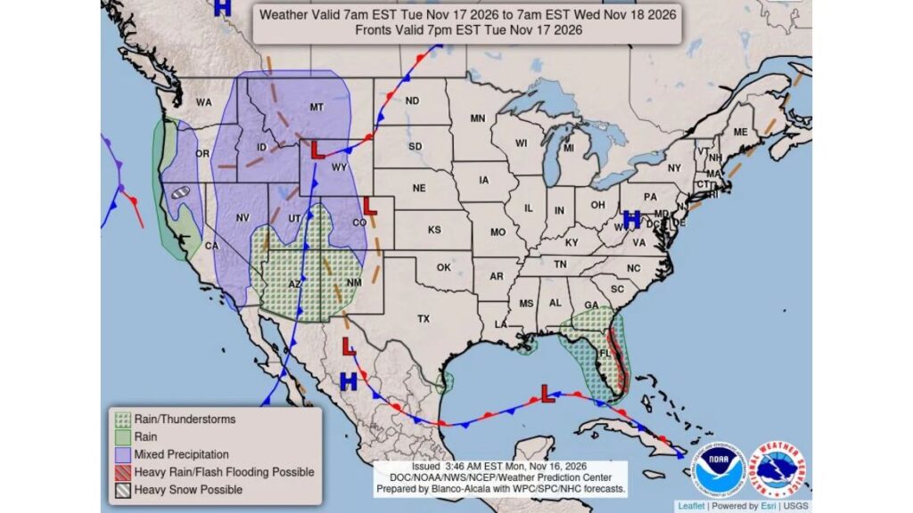
DAYTONA BEACH, FLORIDA — Heavy to excessive rainfall is expected to bring flash flooding and urban flooding along Florida’s I-95 corridor starting Tuesday, November 17, 2026, while a strong storm tracks across the western United States, spreading rain, mountain snow and gusty winds.
The national forecast, issued by the National Weather Service’s Weather Prediction Center at 3:46 a.m. EST Monday, November 16, covers 7 a.m. EST Tuesday through 7 a.m. EST Wednesday, November 18.
Florida: Heavy Rain Along the East Coast
The highest flood risk in the country on Tuesday sits along Florida’s Atlantic coast, following the I-95 corridor. The heavy rain zone stretches roughly from the Jacksonville area south through Daytona Beach, the Space Coast, the Treasure Coast and toward Palm Beach County.
| Florida Area | Tuesday Threat |
|---|---|
| East coast along I-95 | Heavy rain, flash and urban flooding possible |
| Central and interior Florida | Rain and thunderstorms |
| Southwest Florida | Rain and thunderstorms |
| South Georgia | Rain and thunderstorms |
Why Florida’s East Coast Is at Risk
A frontal boundary and an area of low pressure over the Gulf of Mexico, south of Florida, are helping funnel deep tropical moisture toward the state. Onshore winds from the Atlantic can push repeated rounds of heavy rain into the same coastal areas.
Ground Already Saturated
The heavy rain comes as parts of the east coast are still recovering from record flooding earlier this month, when Palm Bay recorded about 20 inches of rain in 48 hours. The St. Johns River is already running high, and forecasters warn that 6 to 10 inches or more could fall in some east-central Florida areas through the end of the week.
Western Storm Brings Rain, Snow and Wind
Out West, a storm system centered over Wyoming and Colorado is pushing across the region:
| Region | Expected Weather |
|---|---|
| Montana, Idaho and Wyoming | Mixed rain and snow |
| Utah, Nevada and western Colorado | Mixed precipitation |
| Eastern Oregon and interior Northern California | Mixed precipitation |
| Southern Oregon mountains | Heavy snow possible |
| Arizona and New Mexico | Rain and thunderstorms |
| Southern Utah and southwest Colorado | Rain and thunderstorms |
| Oregon and Northern California coast | Rain |
Gusty winds are also expected across much of the West as the storm moves through.
California’s Atmospheric River Arrives Next
A Pacific front approaching the California and Oregon coasts marks the start of the next storm. An atmospheric river is expected to bring 2 to 3.5 inches of rain from the Bay Area to San Luis Obispo on Wednesday, with heavy Sierra snow.
Quiet Weather in the Middle of the Country
Much of the central and eastern U.S., from the Plains to the Mid-Atlantic, should stay dry on Tuesday under high pressure centered near West Virginia and Maryland.
Flood Safety Tips for Florida
- Never drive through flooded roads
- Avoid low-lying streets and underpasses
- Clear storm drains near your home
- Keep phone alerts on for flash flood warnings
- Move vehicles to higher ground if needed
Western Travel Tips
- Check mountain pass conditions before driving
- Carry chains in snowy areas
- Secure outdoor items ahead of strong winds
Stay with Bchssreport.com for the latest updates on this story.
About The Author
