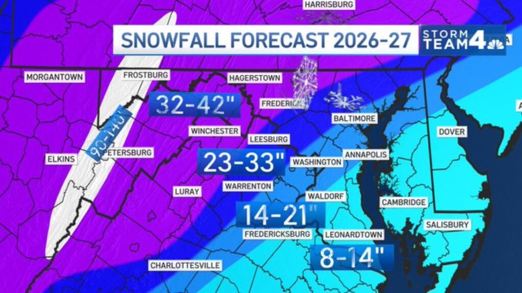
Washington, D.C. Region Could See Above-Average Snow This Winter as One Seasonal Forecast Calls for 23 to 33 Inches Near the Capital and Up to 140 Inches in the Mountains
WASHINGTON, D.C. — Snow lovers in the Washington, D.C. region may finally get their wish. A new winter snowfall forecast for 2026-27 calls for above-average snow across much of Maryland, Virginia and West Virginia, with forecasters saying one or two big coastal storms could drive the totals this season.
Snowfall Forecast for Winter 2026-27
| Zone | Forecast Snow | Areas Included |
|---|---|---|
| Highest mountain ridges | 90 to 140 inches | West Virginia ridges between Elkins and Petersburg |
| Western Maryland and the northern Shenandoah Valley | 32 to 42 inches | Frostburg, Hagerstown, Frederick and Winchester areas |
| D.C. northern and western suburbs | 23 to 33 inches | Leesburg, Washington and Baltimore areas |
| Southern Maryland and northern Virginia Piedmont | 14 to 21 inches | Warrenton, Waldorf and Fredericksburg |
| Lower Eastern Shore and southern Maryland | 8 to 14 inches | Leonardtown, Cambridge, Salisbury and Dover areas |
Mountains Could See More Than 10 Feet
The biggest totals in the forecast are in the West Virginia mountains, where a narrow band of high terrain between Elkins and Petersburg could pick up 90 to 140 inches of snow over the winter. That is the kind of total that could help ski resorts in the region have a strong season.
Western Maryland and the Shenandoah Valley: 32 to 42 Inches
Areas farther east, including Frostburg, Hagerstown and Frederick in Maryland and Winchester in Virginia, fall in the 32 to 42 inch range. These areas often get more snow than the city because of their higher elevation and colder air.
Near the Capital: 23 to 33 Inches
The Washington area and nearby suburbs, including Leesburg and parts of the Baltimore region, are forecast to see 23 to 33 inches. That would be a big season for the area, which often struggles to see much snow in recent winters.
South and East: Smaller but Still Notable Totals
Snow totals drop south and east of the capital, where warmer air from the Chesapeake Bay and Atlantic Ocean often turns snow into rain:
- Warrenton, Waldorf and Fredericksburg: 14 to 21 inches
- Leonardtown, Cambridge, Salisbury and the Dover area: 8 to 14 inches
Why Forecasters Expect Above-Average Snow
The forecaster behind the outlook said they are going above average for a number of reasons, with the biggest factor being the potential for one or two big coastal storms this winter.
A strong El Niño is in place this season. El Niño winters often bring a more active southern storm track, which can feed coastal storms that move up the East Coast. When those storms tap into enough cold air, they can produce heavy snow in the Mid-Atlantic.
Coastal Storms Can Change Everything
In the D.C. region, a single nor’easter can drop a foot or more of snow in one storm. That means just one or two big events could account for most of a season’s total, while other weeks stay mild and dry.
Seasonal Forecasts Come With Uncertainty
Seasonal snow forecasts show the overall expected pattern, not exact amounts. Actual totals will depend on:
- Storm tracks, which can shift by just a few miles
- Timing of cold air when storms arrive
- Whether storms bring snow, sleet or rain
How to Get Ready for a Snowy Winter
- Stock up on ice melt and snow shovels early
- Service snow blowers and check vehicle tires
- Keep an emergency kit in your car
- Prepare for power outages during heavy, wet snow
Outlook: A Winter Worth Watching
If the forecast holds, the Washington, D.C. region could see one of its snowier winters in recent years, especially if a couple of powerful coastal storms line up with cold air.
Stay with Bchssreport.com for the latest updates on this story.
About The Author
