Florida Bracing for One of Its Rainiest, Stormiest Winters on Record as a Near-Record El Niño Sets In This Week and Lasts Through March
ORLANDO, FLORIDA — Florida’s famous “sunny and 75” winter may be hard to find this year. Forecasters say a near-record El Niño pattern is setting in this week and is expected to last through March, potentially making this one of the rainiest, stormiest and most active winters on record for the Florida Peninsula.
The goal of the warning, forecasters stress, is to inform, not alarm.
What to Expect This Winter
A strong El Niño winter in Florida typically brings:
- Frequent storm systems
- Multiple chances for heavy rain and flooding
- Severe storms and tornado risks at some point
- A storm or even two per week at times
It will not rain every day, but storms are expected to be far more frequent than normal for what is usually Florida’s dry season.
Rain Outlook Through December 31
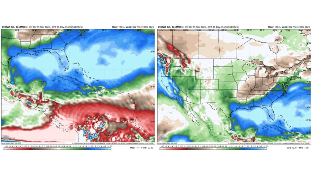
An extended forecast blending many model runs shows an extraordinarily wet pattern for Florida through December 31, 2026:
| Area | Rainfall Above Normal |
|---|---|
| Florida Peninsula | About 4 to 5.5 inches |
| Florida Panhandle and Gulf Coast | About 2 to 4 inches |
| South Georgia and the Carolina coast | About 2 to 4 inches |
| California coast | About 3 to 5 inches |
| Central Plains | Slightly above normal |
| Little Rock, Nashville and Ohio | Drier than normal |
| Great Lakes | Drier than normal |
| Pacific Northwest | Drier than normal |
Orlando and Tampa Could See a Top-5 Rainiest Stretch
If the forecast holds, the rainfall through the end of December would rank among the top five rainiest on record for both Orlando and Tampa.
December Rain Records in Orlando
| Detail | Amount |
|---|---|
| Average December rainfall in Orlando | 2.3 inches |
| Wettest December on record | 12.63 inches in 1997 |
Forecasters say Orlando could easily surpass its normal December rainfall in just the first week of the month.
Florida and California in the Bullseye
The wider U.S. outlook shows the strongest wet signal over Florida and California, both classic targets during a strong El Niño. Meanwhile, a drier-than-normal zone stretches from Little Rock through Nashville and into Ohio, as most storms are expected to track south of those areas through the end of 2026.
Why El Niño Makes Florida Wetter
During El Niño, a stronger subtropical jet stream sets up across the southern U.S. That jet steers frequent storm systems across the Gulf of Mexico and into Florida, bringing more rain, more clouds and more storm chances than a typical winter.
Already a Wet Start
Florida has already seen extreme rainfall this fall, including about 20 inches near Palm Bay earlier this month and another flood threat for the I-95 corridor this week.
Review Your Flood Plan Now
If you live in a flood-prone area, forecasters urge you to take a few minutes to:
- Review what you would do if flooding or high water happens
- Know your evacuation routes and higher ground
- Keep important documents in waterproof containers
- Check flood insurance coverage
- Clear gutters and storm drains around your home
Severe Weather Preparedness
- Have multiple ways to receive warnings
- Know your safe place for tornadoes
- Keep emergency supplies ready
A Winter to Remember
With one of the strongest El Niños ever recorded, some forecasters believe this could be the wildest winter of weather many Floridians have ever experienced.
Stay with Bchssreport.com for the latest updates on this story.
About The Author
