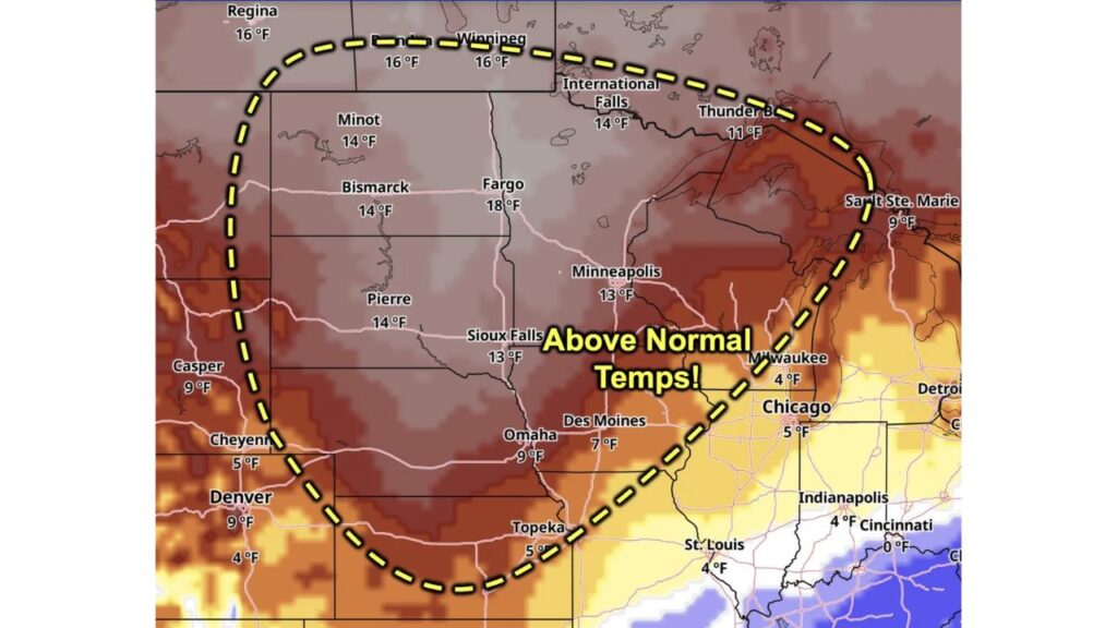
Northern Plains and Upper Midwest Set for Warm Rebound Next Week as Fargo Runs 18 Degrees Above Normal, Before a Storm System Brings Temperatures Back to Seasonable
FARGO, NORTH DAKOTA — While cooler temperatures are expected across the Plains this weekend, the chill will not last long. Forecast trends show warmer than normal temperatures working their way back into the Plains and Upper Midwest next week, ahead of the next storm system.
Once that system moves through, temperatures are expected to become much more seasonable.
Forecast Window: November 16 to November 21
The temperature outlook covers Monday, November 16, through Saturday, November 21, 2026, and shows how far temperatures are expected to run above normal.
Temperature Departures From Normal by City
| City | Above Normal |
|---|---|
| Fargo, North Dakota | 18°F |
| Regina, Saskatchewan | 16°F |
| Winnipeg, Manitoba | 16°F |
| Minot, North Dakota | 14°F |
| Bismarck, North Dakota | 14°F |
| Pierre, South Dakota | 14°F |
| International Falls, Minnesota | 14°F |
| Minneapolis, Minnesota | 13°F |
| Sioux Falls, South Dakota | 13°F |
| Thunder Bay, Ontario | 11°F |
| Omaha, Nebraska | 9°F |
| Casper, Wyoming | 9°F |
| Denver, Colorado | 9°F |
| Sault Ste. Marie, Michigan | 9°F |
| Des Moines, Iowa | 7°F |
| Cheyenne, Wyoming | 5°F |
| Topeka, Kansas | 5°F |
| Chicago, Illinois | 5°F |
| Milwaukee, Wisconsin | 4°F |
| St. Louis, Missouri | 4°F |
| Indianapolis, Indiana | 4°F |
| Cincinnati, Ohio | Near normal |
Biggest Warmth Centered on the Dakotas and Minnesota
The warmest departures are focused across the Dakotas, Minnesota and southern Canada. Fargo leads at 18 degrees above normal, with Minot, Bismarck and Pierre all running about 14 degrees above normal.
Upper Midwest and Central Plains Also Above Normal
The warm air spreads into the Upper Midwest and central Plains, with:
- Minneapolis and Sioux Falls about 13 degrees above normal
- Omaha about 9 degrees above normal
- Des Moines about 7 degrees above normal
Smaller Departures Toward the Great Lakes and Ohio Valley
Farther east, the warm signal fades. Chicago, Milwaukee, Indianapolis and St. Louis run only about 4 to 5 degrees above normal, while Cincinnati stays close to normal.
Warmth Ahead of the Next Storm System
The warm-up comes as southerly winds pull milder air north ahead of the next storm system. Long-range forecasts have been showing a powerful storm developing across the central U.S. heading into Thanksgiving week, possibly bringing storms, snow and strong winds.
Cooler, More Seasonable Air After the Storm
Once the storm moves through the region, temperatures are expected to drop back closer to normal, bringing a more typical late-November feel to the Plains and Midwest.
What the Warm-Up Means for the Region
The above-normal temperatures could bring:
- Comfortable days for outdoor work and travel
- Extra time for late-season farm activities
- Delayed snow in areas still waiting for their first snowfall
- Lower heating costs for a few days
A Slow Start to Winter Continues
The warm-up adds to a slow start to winter across much of the Plains, where snow cover remains well below normal for mid-November.
Tips for the Week Ahead
- Enjoy the mild weather while it lasts
- Prepare for a sharp change once the storm system arrives
- Watch forecasts closely ahead of Thanksgiving travel
Stay with Bchssreport.com for the latest updates on this story.
About The Author
