West Locks Into a Parade of Cold Storms Starting Tonight With Heavy Rain and Big Mountain Snow, While the Catskills and Michigan’s Upper Peninsula Battle for the East’s Best Snow
UNITED STATES — The big weather story for the next week is in the West, where a series of cold storm systems begins overnight Thursday, November 12, 2026, and is expected to continue for the foreseeable future. These storms will bring coastal impacts, heavy rain and mountain snow, even deep into the interior West.
Meanwhile, the Northeast and Appalachians remain on track for an elevation snow event heading into the weekend, though it now looks less robust than earlier forecasts suggested.
The West: A Pattern That Looks Locked In
Forecasters say the stormy pattern in the West looks locked in, with some daily breaks between systems. The storms are expected to bring:
- Coastal impacts along the Pacific Coast
- Heavy rain in lower elevations
- Significant mountain snow from the Cascades and Sierra to the Rockies
Seven-Day Snow Totals Through November 19
Forecast snowfall through 7 p.m. EST Thursday, November 19, shows the heaviest amounts in the Western mountains:
| Area | Forecast Snow |
|---|---|
| Sierra Nevada, California | About 14 to 22+ inches in the high country |
| Colorado Rockies, including the San Juans | About 14 to 22 inches in spots |
| Utah mountains | About 8 to 14+ inches |
| Wyoming ranges | About 4 to 14 inches |
| Idaho and Montana mountains | About 4 to 14 inches |
| Washington and Oregon Cascades | About 4 to 14 inches |
| Northern Arizona mountains | About 1 to 2 inches |
| Michigan’s Upper Peninsula | About 8 to 14 inches in the snowiest spots |
| Catskills, New York | Several inches possible |
| Lake Erie snow belt | Around 3 inches |
The highest point total on the map reaches about 91.6 inches in the highest Western mountain terrain.
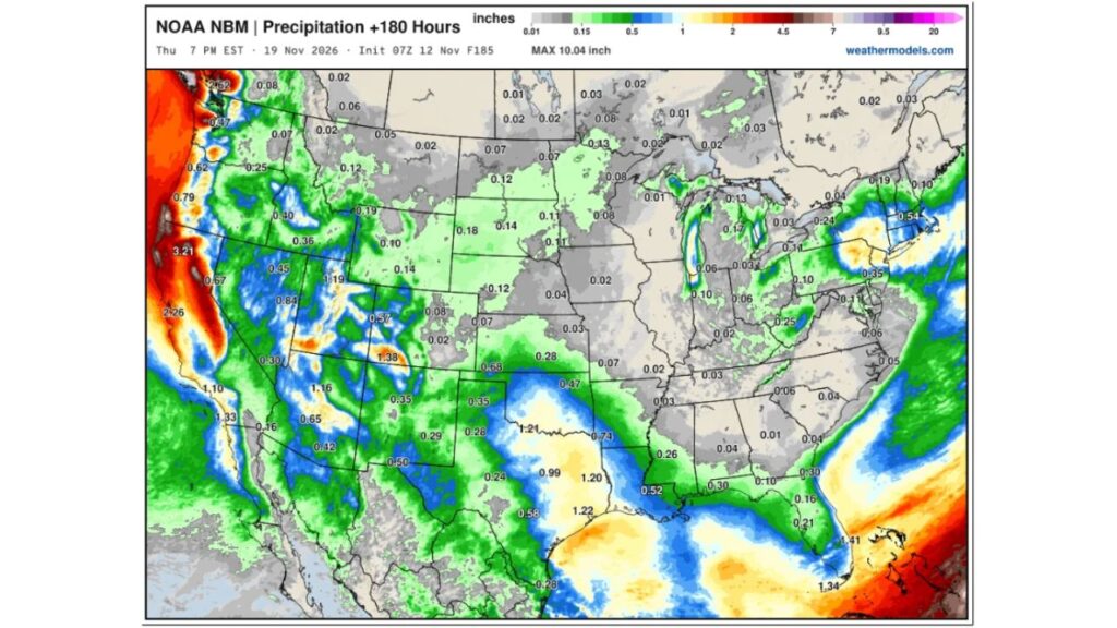
Seven-Day Rain and Melted Precipitation Totals
| Area | Forecast Precipitation |
|---|---|
| Northern California coast | About 2.3 to 3.2+ inches |
| Washington coast and Olympics | About 2.5 inches |
| Oregon coast | About 0.6 to 0.8 inch |
| Utah and western Colorado | About 1.2 to 1.4 inches |
| Arizona | About 1.2 inches in spots |
| Central Texas and Oklahoma | About 1 to 1.2 inches |
| South Florida | About 1.3 to 1.4 inches |
| Cape Cod and southeast New England | About 0.5 inch |
| Central Plains and Midwest | Mostly light |
The highest total on the map tops 10 inches of precipitation in the wettest Pacific Coast mountain areas.
Northeast and Appalachia: Elevation Snow, but Weaker Than Expected
The Northeast and Appalachians are still set for snow in higher elevations this weekend, but forecasters say it now looks much less robust than it did a day earlier.
Catskills vs. Upper Peninsula: Who Gets More Snow?
It is a toss-up over which area sees more snow: the Catskills in New York or Michigan’s Upper Peninsula. At least one forecaster is putting their money on the UP, where lake-enhanced snow could boost totals.
The Real Takeaway in the East: The Cold
For much of the eastern U.S., the cold shot is the bigger story. Temperatures are expected to run below normal into the weekend, bringing freezing mornings and gusty winds.
What This Means for Western Travel and Ski Areas
- Mountain passes could see snow-covered roads and chain controls
- Ski resorts may get a major boost ahead of Thanksgiving
- Coastal areas could see flooding and rough surf
- Burn scars may face debris flow risks in heavy rain
Travel Tips
- Check road conditions before mountain travel
- Carry chains and emergency supplies
- Watch for flood alerts along the coast
Stay with Bchssreport.com for the latest updates on this story.
About The Author
