New York City, Philadelphia and the Northeast Brace for Up to 2 Inches of Rain Thursday Into Friday, While Northeast Pennsylvania Could See Up to 3 Inches of Snow
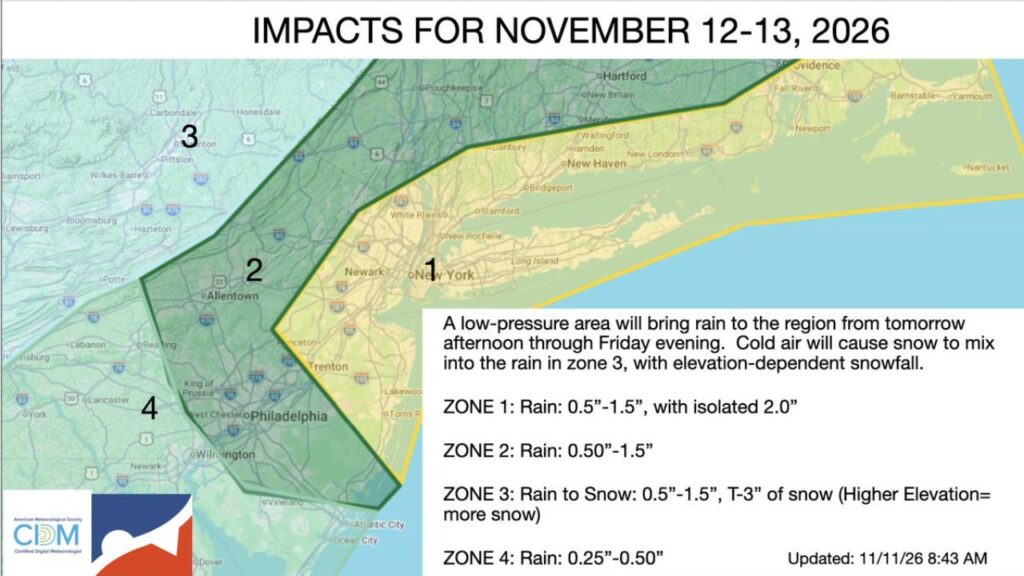
NEW YORK, NEW YORK — A low-pressure system is set to bring soaking rain to much of the Northeast from Thursday afternoon, November 12, 2026, through Friday evening, November 13. Farther inland, colder air will allow snow to mix in, especially across the higher elevations of northeast Pennsylvania.
The impact forecast was updated at 8:43 a.m. Wednesday, November 11.
Storm Timing
| Time | What to Expect |
|---|---|
| Thursday afternoon, Nov. 12 | Rain begins spreading across the region |
| Thursday night | Steady rain, with snow mixing in across northeast Pennsylvania |
| Friday, Nov. 13 | Rain continues, snow in higher elevations |
| Friday evening | Precipitation winds down |
Four Impact Zones Across the Region
The forecast splits the region into four zones, each with different expected impacts:
| Zone | Areas Included | Expected Impacts |
|---|---|---|
| Zone 1 | New York City, Long Island, northeast New Jersey, coastal Connecticut, Rhode Island and southeast Massachusetts | Rain of 0.5 to 1.5 inches, isolated 2 inches |
| Zone 2 | Philadelphia, Allentown, King of Prussia, West Chester, Hudson Valley and interior Connecticut | Rain of 0.5 to 1.5 inches |
| Zone 3 | Northeast Pennsylvania, including Scranton, Wilkes-Barre, Hazleton and the Poconos region | Rain changing to snow, 0.5 to 1.5 inches of precipitation, trace to 3 inches of snow |
| Zone 4 | Reading, Lancaster, York, Lebanon and northern Delaware | Rain of 0.25 to 0.5 inch |
Zone 1: Heaviest Rain Along the Coast
The wettest conditions are expected in Zone 1, which includes major cities like New York, Newark, White Plains, Stamford, Bridgeport, New Haven, Providence and the Jersey Shore near Lakewood and Toms River. Rain totals of 0.5 to 1.5 inches are likely, with isolated totals near 2 inches.
Zone 2: Soaking Rain From Philadelphia to Hartford
Zone 2 covers a band from the Philadelphia suburbs north through Allentown, the Hudson Valley near Poughkeepsie, and into Hartford and New Britain. These areas can expect 0.5 to 1.5 inches of rain.
Zone 3: Rain Turning to Snow in Northeast Pennsylvania
Zone 3 is where things get wintry. Across northeast Pennsylvania, including Scranton, Wilkes-Barre, Hazleton, Pittston, Carbondale, Honesdale, Bloomsburg and toward Williamsport, rain is expected to change to snow.
Snow totals will depend heavily on elevation:
- Lower valleys: a trace or light coating
- Higher elevations: up to 3 inches
Zone 4: Lighter Rain in South-Central Pennsylvania
Zone 4, which includes Reading, Lancaster, York, Lebanon and northern Delaware, will see lighter rain, generally 0.25 to 0.5 inch.
Part of a Colder, Stormier Pattern
This system follows a midweek cold front that is bringing colder air to the eastern U.S. Behind the storm, temperatures are expected to stay cooler than normal into the weekend, with the possibility of more wintry weather in interior areas.
Possible Impacts
- Wet roads and slower commutes Thursday evening and Friday
- Ponding on highways and in low-lying areas
- Slick spots in the Poconos and northeast Pennsylvania where snow falls
- Airport delays at major hubs like JFK, LaGuardia, Newark and Philadelphia
Travel Tips
- Allow extra time for commutes
- Avoid flooded roads
- Check road conditions before driving in higher elevations
- Keep an eye on flight status if traveling
Stay with Bchssreport.com for the latest updates on this story.
About The Author
