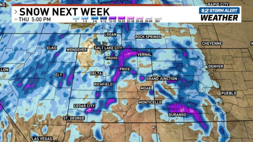
Utah Mountains Could Finally See Several Rounds of Significant Snow November 16 to 20 as a Colder, More Active Pattern Raises Hopes for the First Valley Freeze
SALT LAKE CITY, UTAH — After a slow, dry start to the season, significant mountain snow is starting to show up in the forecast for Utah next week, November 16 to 20, 2026.
Forecast models are hinting at a much more active and colder pattern, with the potential for several rounds of mountain snow across the state.
The Big Question for the Valleys
The biggest question now is whether Utah’s valleys will finally see their first widespread freeze and snowfall of the season. Forecasters say it is still several days out, with plenty of details to work out, but the pattern looks more promising for winter weather.
Snow Forecast Through Thursday Evening
The latest snowfall outlook through 5 p.m. Thursday, November 19, shows:
| Area | Forecast Snow |
|---|---|
| Wasatch Plateau and mountains east of Provo | About 12 to 18+ inches |
| Uinta Mountains toward Vernal | About 12 to 18 inches |
| Central Utah mountains near Richfield | About 6 to 18 inches |
| Mountains near Cedar City | About 6 to 18 inches |
| Mountains near Price | About 6 to 12 inches |
| San Juan Mountains near Durango, Colorado | About 12 to 24 inches |
| Colorado Rockies | About 6 to 12 inches |
| Salt Lake City and Logan valleys | About 1 to 3 inches |
| Northern Nevada mountains near Elko and Ely | About 3 to 6 inches |
| St. George and Las Vegas | Little to none |
Heaviest Snow in Central and Northeast Utah
The brightest colors on the forecast map, showing the highest totals, are centered over the mountains east of Provo, near Price, and into the Uinta Mountains toward Vernal. Some spots could see more than 18 inches.
Valleys Could See Their First Flakes
Lower areas like Salt Lake City, Logan and Provo show light snow in the outlook, generally 1 to 3 inches. If colder air arrives as expected, this could mark the first valley snowfall of the season.
Snow Spreads Into Colorado and Nevada
The storm pattern is not limited to Utah. The San Juan Mountains in southwest Colorado could see 12 to 24 inches, while the Colorado Rockies pick up 6 to 12 inches. Mountains in northern Nevada may get a few inches as well.
A Welcome Change After a Dry Start
The Western U.S. has had a very slow start to winter. As of early November, only about 1.9% of the Lower 48 had snow on the ground, and cities like Denver and Cheyenne were still waiting for their first snow.
Great News for Utah Ski Resorts
Several rounds of snow could help Utah’s ski resorts build a base ahead of Thanksgiving, when many resorts hope to open. Earlier long-range forecasts also showed 6 to 7 inches or more in the Wasatch and Uintas the week before Thanksgiving.
Travel Impacts to Watch
If the storms arrive as forecast, travelers could see:
- Snow-packed roads in mountain canyons
- Slick conditions on I-80 and I-70 through the mountains
- Chain requirements on some routes
- Possible delays for holiday travel planning
How to Get Ready
- Check tires and wipers before the storms arrive
- Pack an emergency kit for mountain travel
- Protect outdoor pipes if a valley freeze develops
- Follow forecast updates through the weekend
Stay with Bchssreport.com for the latest updates on this story.
About The Author
