Central and South Texas Could Pick Up 3 to 5 Inches of Rain Through Monday as Mid-Level Disturbance Brings Drought Relief and Scattered Flash Flooding Risk
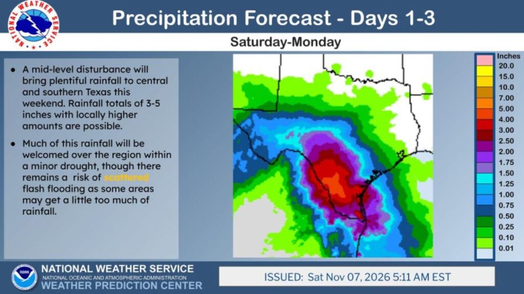
SAN ANTONIO, TEXAS — A mid-level disturbance is bringing plentiful rain to central and southern Texas this weekend, with 3 to 5 inches forecast and locally higher amounts possible through Monday, November 9, 2026.
The rain will be welcome across a region dealing with minor drought, but forecasters warn of a risk for scattered flash flooding where storms dump too much rain too fast.
Forecast Window: Saturday Through Monday
The National Weather Service’s Weather Prediction Center issued its three-day rainfall outlook at 5:11 a.m. EST Saturday, November 7, covering Saturday through Monday.
| Detail | Information |
|---|---|
| Forecast period | Saturday, Nov. 7, through Monday, Nov. 9 |
| Main cause | Mid-level disturbance over Texas |
| Forecast rainfall | 3 to 5 inches, locally higher |
| Flood risk | Scattered flash flooding |
Where the Heaviest Rain Is Expected
| Area | Forecast Rainfall |
|---|---|
| South-central Texas, south of San Antonio | About 4 to 5+ inches |
| San Antonio area | About 3 to 4 inches |
| Coastal Bend and Victoria area | About 2 to 4 inches |
| Corpus Christi area | About 2 to 3 inches |
| Austin and the Hill Country | About 1.5 to 2.5 inches |
| Western Houston area | About 1 to 2 inches |
| East Texas | About 0.5 to 1 inch |
| Far West Texas | Light amounts |
A Bullseye of Heavy Rain in South-Central Texas
The heaviest rain on the forecast map forms a large bullseye across south-central Texas, roughly between San Antonio, the Coastal Bend and areas toward the Rio Grande. In this zone, totals could top 5 inches in spots.
Welcome Relief for Drought-Stricken Areas
Much of central and southern Texas has been in minor drought. This rain could:
- Recharge soil moisture ahead of winter
- Boost stock tanks and small reservoirs
- Help ranchers and farmers with pasture and crops
- Ease fire danger in dry areas
Scattered Flash Flooding Possible
While the rain is needed, some areas may get more than the ground can handle. Flash flooding could develop in:
- Low-water crossings
- Creeks, draws and drainage ditches
- Urban streets in San Antonio and nearby cities
- Low-lying neighborhoods
Why This Storm Is Producing So Much Rain
The mid-level disturbance is lifting moist Gulf air over Texas, causing repeated rounds of rain and storms. When storms keep moving over the same areas, totals can climb quickly.
Part of a Wet Pattern for South Texas
Earlier forecasts had already called for 2 to 4 inches near and north of Laredo, and storms were highlighted for South Texas in Saturday’s thunderstorm outlook. This latest forecast increases rain totals across a wider area.
Flood Safety Reminders
- Turn around, don’t drown at flooded crossings
- Avoid driving at night during heavy rain
- Stay away from rising creeks
- Keep phone alerts on for flash flood warnings
- Have a plan to reach higher ground if water rises
Outlook: Drier Weather Returns Midweek
Rain should taper off after Monday, with drier conditions expected to return by the middle of the week.
Stay with Bchssreport.com for the latest updates on this story.
About The Author
