Northeast and Mid-Atlantic Lose Their Mild Air as Canadian Cold Noses South, With Frigid Quebec and Labrador Air Raising Odds of Interior Snow
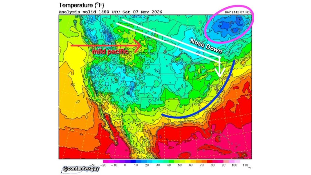
NORTHEAST — The mild weather that has dominated much of the eastern United States is beginning to fade. A “nose down” weather pattern is setting up over the East, steering colder air from Canada southeast toward the Northeast and Mid-Atlantic.
At the same time, a pool of very cold air over Quebec and Labrador is being watched closely as a possible source for interior snow in the weeks ahead.
Temperature Snapshot: Saturday Morning, November 7
The temperature analysis at 9 a.m. EST Saturday, November 7, 2026, showed a clear contrast across North America:
| Region | Morning Temperatures |
|---|---|
| Quebec and Labrador | About 10 to 25°F |
| Northern Plains and Upper Midwest | 30s |
| Rocky Mountain high country | 20s to 30s |
| Great Lakes and Northeast interior | 30s to 40s |
| Ohio Valley and Mid-Atlantic | 40s to 50s |
| Southeast | 50s to 60s |
| Gulf Coast, South Texas and Florida | 70s to 80s |
| Pacific Coast | 50s to 60s |
Mild Pacific Air Floods the West
While the East cools, mild Pacific air continues to stream into western North America, keeping much of the West and northern Rockies milder than they would normally be in early November.
What the “Nose Down” Pattern Means
The “nose down” setup describes cold air diving southeast from central Canada across the Great Lakes and into the Northeast. This pattern helps push cooler air deeper into the eastern U.S., ending the long run of unseasonable warmth.
Cold Air Boundary Arcs From Texas to the East Coast
A boundary marking the edge of the cooler air curves from Texas across the Gulf Coast states and up through the Southeast toward the Mid-Atlantic coast. North and west of that line, temperatures are trending cooler, while areas south and east remain mild and humid.
Quebec and Labrador: The Cold Reservoir to Watch
The coldest pocket on the map sits over Quebec and Labrador, where morning temperatures were in the teens and 20s. Forecasters say this cold air could be tapped in the coming weeks, potentially supplying enough cold for snow in the interior Northeast.
Possible “Snowy Mischief” for the Interior
If that cold air gets pulled south at the right time, areas that could see early-season snow include:
- Interior New England
- Upstate New York
- Northern Pennsylvania
- Higher elevations in the Appalachians
The exact timing and amounts are still uncertain.
Part of a Larger Cool-Down Across the East
This pattern change lines up with forecasts calling for a big chill late next week, including:
- First 50-degree highs of fall in Washington, D.C.
- Temperatures 10 to 20 degrees below normal in Florida
- Possible first snowflakes in parts of the Mid-Atlantic
Get Ready for a Colder Pattern
- Check heating systems and replace furnace filters
- Prepare winter gear like coats, gloves and hats
- Stock up on ice melt if you live in snow-prone areas
- Winterize outdoor faucets and hoses
Outlook: Warmth Fades, Winter Inches Closer
After weeks of mild weather, the East is heading into a cooler pattern, while forecasters keep a close eye on Canada’s cold air as a possible trigger for the first snow of the season.
Stay with Bchssreport.com for the latest updates on this story.
About The Author
