Eastern Arkansas, Northern Louisiana, Northwest Mississippi and Western Tennessee Faced Flooding Threat Tuesday Evening as Heavy-Rain Thunderstorms Expanded Through 10 p.m.
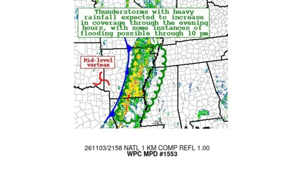
EASTERN ARKANSAS — Thunderstorms with heavy rainfall were expected to increase in coverage across parts of the Mid-South on Tuesday evening, November 3, 2026, raising the risk of flooding through about 10 p.m.
The Weather Prediction Center issued Mesoscale Precipitation Discussion #1553 for the region late Tuesday afternoon.
Areas Included in the Flood Concern
The discussion covered parts of:
| State | Area Affected |
|---|---|
| Arkansas | Eastern Arkansas |
| Louisiana | Northern Louisiana |
| Mississippi | Northwest Mississippi |
| Tennessee | Western Tennessee |
The outlined zone also extended close to southeast Missouri near the Bootheel.
Timing: Late Afternoon Through 10 p.m.
| Time | What to Expect |
|---|---|
| About 5 p.m. CDT Tuesday | Radar shows a line of storms developing |
| Tuesday evening | Storms expected to increase in coverage |
| Through about 10 p.m. | Some instances of flooding possible |
A Long Band of Storms on Radar
Radar imagery from about 5 p.m. CDT showed a long, narrow band of rain and thunderstorms stretching from northern Louisiana north through eastern Arkansas and toward western Tennessee.
Brighter colors within the band showed pockets of heavier rain that could drop a lot of water in a short time.
Mid-Level Disturbance Helping Fuel the Storms
The discussion highlighted a mid-level vortmax, a spinning pocket of energy in the atmosphere, located to the west of the storm band near western Arkansas.
That feature helped provide lift for storms to keep forming and expanding through the evening.
Why Flooding Was a Concern
When storms form in a line and keep moving over the same areas, rain can build up quickly. That can lead to:
- Flooded streets and low-lying roads
- Overflowing ditches and small creeks
- Ponding in poorly drained areas
- Dangerous driving conditions during heavy downpours
Part of the Same Storm System Moving East
These storms were part of the larger storm system that brought severe weather to Oklahoma, Kansas and North Texas on Monday night. As the system moved east, it spread rain and storms into the Mid-South on Tuesday before weakening as it reached the Deep South.
Storms Expected to Weaken Overnight
Forecasters expected the activity to lose strength later Tuesday night as the upper-level support lifted away, reducing the flood threat after 10 p.m.
Flood Safety Reminders
- Turn around, don’t drown if water covers a road
- Avoid driving at night through areas with heavy rain
- Stay away from flooded ditches and creeks
- Keep weather alerts on for any flash flood warnings
What Comes Next for the Mid-South
After the storms moved through, the region was expected to turn drier and cooler, as colder air spreads across much of the eastern U.S. later in the week.
Stay with Bchssreport.com for the latest updates on this story.
About The Author
