Alabama Rain Increases Ahead of Cold Front, but No Severe Storms Expected Tonight or Thursday, With About an Inch in the Tennessee Valley and Under a Quarter Inch Near the Coast
BIRMINGHAM, ALABAMA — Rain is set to increase across Alabama over the next 6 to 12 hours as an upper-level trough and surface cold front approach, but forecasters say no severe storms are expected tonight or Thursday.
Rain Moves in Ahead of the Front
The approaching front is pushing moisture into the state, bringing widespread rain over the next several hours. Rain coverage will grow from west to east as the system moves in.
Organized Storms to the West Expected to Weaken
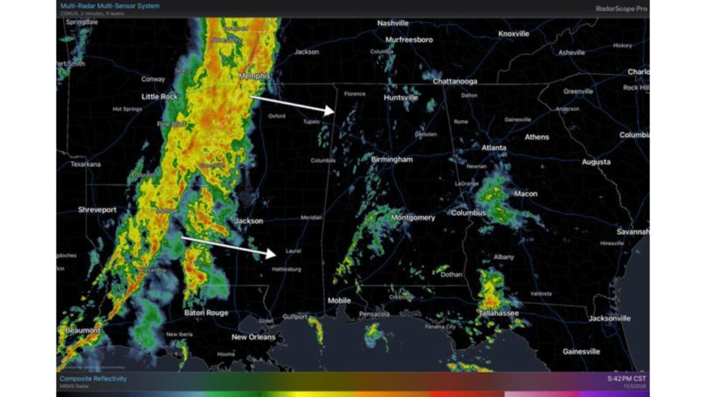
Radar shows an organized area of rain and storms to the west, stretching across Arkansas, western Mississippi and Louisiana, including areas near Little Rock and Jackson.
That activity is moving east but is expected to weaken later tonight as the upper-level support that fuels the storms lifts away from the Deep South.
No Severe Weather Expected for Alabama
Earlier in the week, forecasters had been watching for a possible strong to severe storm threat in South Alabama with this system. Now, they say severe storms are not expected across Alabama tonight or Thursday.
Radar Snapshot: Scattered Showers Across Alabama and Georgia
At the time of the latest update, radar showed:
| Area | Activity |
|---|---|
| Arkansas and western Mississippi | Organized line of rain and storms |
| Central Alabama near Birmingham | Scattered light showers |
| Southeast Alabama and Georgia | Scattered showers near Macon, Albany and Tallahassee |
| North Alabama near Huntsville | Mostly quiet but rain expected to increase |
Rain Totals: About an Inch North, Under a Quarter Inch on the Coast
Rainfall amounts will vary a lot from north to south:
| Area | Expected Rainfall |
|---|---|
| Tennessee Valley | Around 1 inch |
| Central Alabama | About 0.5 to 1 inch |
| South Alabama | About 0.4 to 0.5 inch |
| Alabama Gulf Coast | Under 0.25 inch |
Seven-Day Rain Totals Through Tuesday, November 10
The seven-day rain forecast ending 7 p.m. EST Tuesday, November 10, shows heavier totals north and lighter amounts south:
| Area | Forecast Rainfall |
|---|---|
| North Alabama | About 1.2 to 1.4 inches |
| Central Alabama | About 0.8 to 1.0 inch |
| South Alabama | About 0.4 to 0.5 inch |
| Alabama coast | About 0.1 to 0.2 inch |
| Middle Tennessee | Up to about 2.9 inches |
| Northern Mississippi | About 1.3 to 1.7 inches |
| North Georgia | About 1.0 to 1.3 inches |
Why South Alabama Will See Less Rain
As the upper support pulls north and away from the Gulf Coast, the heaviest rain will stay focused farther north, closer to the Tennessee Valley. That leaves South Alabama and the coast with much lighter totals.
Welcome Rain After a Long Dry Spell
The rain is good news for a state that went through a long dry spell for much of October. Even moderate totals can help soil moisture, lawns and gardens across north and central Alabama.
Travel Tips for Wet Roads
- Slow down on wet roads, especially during the evening commute
- Turn on headlights in rain
- Leave extra distance between vehicles
- Watch for ponding in low spots
Outlook: Dry and Cooler Weather Returns Later This Week
After this system moves out, Alabama is expected to turn drier and more seasonal heading into the weekend, with cooler mornings settling in.
Stay with Bchssreport.com for the latest updates on this story.
About The Author
