
Northern Illinois and Southern Wisconsin Warm Into the 80s This Weekend Before a Stronger Cold Front Brings Rain Chances and a Big Cooldown Next Week
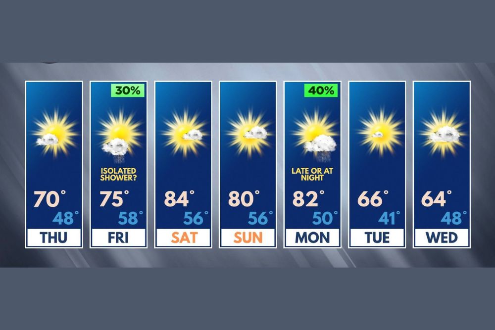
Northern Illinois – The forecast for Northern Illinois and Southern Wisconsin has picked up a couple of rain chances over the next week, but neither is expected to bring significant impacts. A few quick showers are possible on Friday as warmer air moves in, followed by a gorgeous weekend with highs in the 80s. A slightly more substantial rain chance arrives late Monday or Monday night with a stronger cold front, which will send temperatures tumbling into the 60s by midweek.
Thursday: Seasonable and Pleasant
Thursday will feature mostly sunny skies with a high near 70 degrees and an overnight low around 48. It will be a comfortable, seasonable fall day, perfect for outdoor activities.
Friday: A Few Quick Showers Possible
On Friday, the region will begin transitioning from a cooler, more seasonable air mass to a much warmer one. As that change happens, a little slug of moisture may bring just enough energy to produce a few quick showers. The chance of rain is around 30 percent.
It is hard to pin down exactly when the showers might happen, but the morning hours appear to have the better chance. The afternoon chances, while not zero, look lower, and the evening should be dry, which is great news for Friday night football games.
Friday’s high is expected to reach about 75 degrees, with a warmer overnight low near 58.
The Weekend: Gorgeous and Warm
The weekend looks fantastic. Saturday is expected to be the warmest day of the stretch, with highs near 84 degrees under mostly sunny skies. Overnight lows will be mild, near 56.
Sunday will stay warm and pleasant, with highs around 80 degrees and lows near 56. It is the kind of weekend that is perfect for fall festivals, pumpkin patches, apple orchards, hiking, biking, and yard work.
Highs in the 80s are well above normal for mid-October in Northern Illinois and Southern Wisconsin, where average highs are usually in the 60s.
Monday: Warm Before a Stronger Cold Front
Monday will start out warm, with highs near 82 degrees. However, a stronger cold front is expected to move through the region late Monday or Monday night, bringing a 40 percent chance of rain.
This rain chance is slightly more substantial than Friday’s and will be watched more closely. At this point, severe weather is not a major concern, but forecasters will keep an eye on it as the front gets closer.
Monday night’s low is expected to drop to around 50 degrees as cooler air begins moving in behind the front.
Big Cooldown Tuesday and Wednesday
Behind the cold front, temperatures will drop sharply. Tuesday is expected to reach only around 66 degrees, with a chilly overnight low near 41. Wednesday should top out near 64, with a low around 48.
That is a drop of nearly 20 degrees from the warm weekend highs, bringing a true taste of fall back to the region.
Make the Most of the Warm Weekend
With temperatures in the 80s and plenty of sunshine, the weekend is a great time to enjoy one last stretch of summer-like weather. Fall colors are beginning to appear across Northern Illinois, making it a great time for scenic drives and visits to places like Rock Cut State Park, Starved Rock, and the Wisconsin countryside.
Prepare for Cooler Air Next Week
With much colder nights coming by Tuesday, it is a good time to start preparing for fall and winter. Gardeners may want to keep an eye on overnight temperatures, as lows in the low 40s could lead to frost concerns in some rural and low-lying spots later in the week.
It is also a good time to check furnaces, clean gutters, and put away outdoor items before colder and windier weather becomes more common.
Stay Tuned for Updates
While neither rain chance looks significant right now, forecasts can change, especially with a stronger cold front on the way. Residents should keep checking for updates as Monday gets closer.
For more Northern Illinois and Southern Wisconsin weather updates, stay with bchssreport.com.