
Flash Flood Risk Rises Across South Texas and the Rio Grande Valley as a Band of Very Heavy Rain Brings Hourly Rates of 2 to 3 Inches
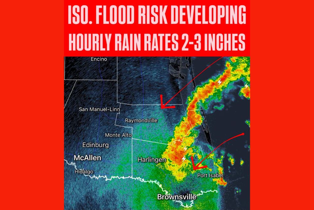
Rio Grande Valley, Texas – The flash flood risk is increasing across parts of South Texas and the Rio Grande Valley as a band of very heavy rain moves in from the Gulf. Radar at 10:10 p.m. CDT showed an intense line of rain and thunderstorms pushing onshore near the coast, with hourly rainfall rates of 2 to 3 inches possible. Some areas could pick up a few inches of rain in a short period of time, leading to an isolated flood risk across parts of the region.
Heavy Rain Band Moving Onshore
Radar showed a long, narrow band of heavy rain and storms stretching along the Texas coast, running from the waters off Kenedy County south toward eastern Cameron County. The heaviest rain was concentrated near and just north of Harlingen, extending toward Port Isabel and the Laguna Madre.
Frequent lightning was detected within the band, especially near the coast and over areas east of Harlingen. The storms were moving inland toward the southwest, putting more communities in the path of the heavy rain over the next few hours.
Areas Most at Risk
Communities in Cameron County and Willacy County were closest to the heaviest rain at the time, including areas around Harlingen, Port Isabel, Raymondville, and the Laguna Vista and Rio Hondo areas. As the rain band continues to move, Brownsville and areas farther inland, including San Benito, Monte Alto, Edinburg, McAllen, and Hidalgo, could see heavy rain as well.
Farther north, lighter rain was spreading toward Raymondville, San Manuel-Linn, and parts of Kenedy County, though the heaviest rates remained closer to the coast.
Rainfall Rates of 2 to 3 Inches Per Hour
The biggest concern with this band is the intensity of the rain. Hourly rainfall rates of 2 to 3 inches are possible within the strongest storms. Rain falling this quickly can overwhelm storm drains, flood streets and intersections, and cause water to build up rapidly in low-lying neighborhoods.
Even if the rain does not last long in one spot, these rates can produce a few inches of rain in a short amount of time, which is more than enough to cause flash flooding.
Why the Rio Grande Valley Floods Easily
The Rio Grande Valley is especially prone to flooding because of its flat terrain. When heavy rain falls, water has nowhere to quickly drain, causing it to pool in streets, yards, and neighborhoods. Many areas rely on drainage ditches and canals, which can fill up quickly during intense rainfall.
Urban areas like Brownsville, Harlingen, and McAllen can see rapid street flooding, especially in areas with older drainage systems or where debris blocks storm drains.
Turn Around, Don’t Drown
The most important safety message during flash flooding is to never drive through flooded roads. It only takes 6 inches of moving water to cause a vehicle to lose control, and 12 inches can sweep many cars away. At night, flooded roads are especially dangerous because it is harder to see how deep the water is.
If you see water covering a road, turn around and find another route. Floodwater can also hide washed-out pavement, open manholes, and debris.
Nighttime Flooding Danger
Because this heavy rain is moving in late at night, many people may be asleep when flooding begins. Residents in flood-prone areas should make sure their phones are charged and that emergency alerts are turned on so they can receive warnings if flooding develops.
Anyone living in low-lying areas or near drainage ditches should be ready to move to higher ground if water starts to rise.
Lightning and Gusty Winds
Along with the heavy rain, the storms are producing frequent lightning. Anyone outside should head indoors immediately when thunder is heard. Some storms may also bring gusty winds, especially near the coast.
Part of an Active Pattern
This heavy rain is part of a larger, active weather pattern across Texas and the Gulf. Moisture from the Gulf continues to stream into South Texas, and forecasters are also watching the southwestern Gulf for possible slow tropical development over the next several days. That means more rounds of heavy rain could be possible across South Texas in the days ahead.
Stay Weather Aware
Residents across the Rio Grande Valley and South Texas should stay alert through the night and into the early morning hours. Conditions can change quickly, and flash flooding can develop with little warning when rain rates are this high.
For more South Texas weather updates and flood alerts, stay with bchssreport.com.