
Tornado Warning for Fort Morgan Expires as Two Possible Waterspouts Move Onshore in Baldwin County, With No Damage Reported So Far
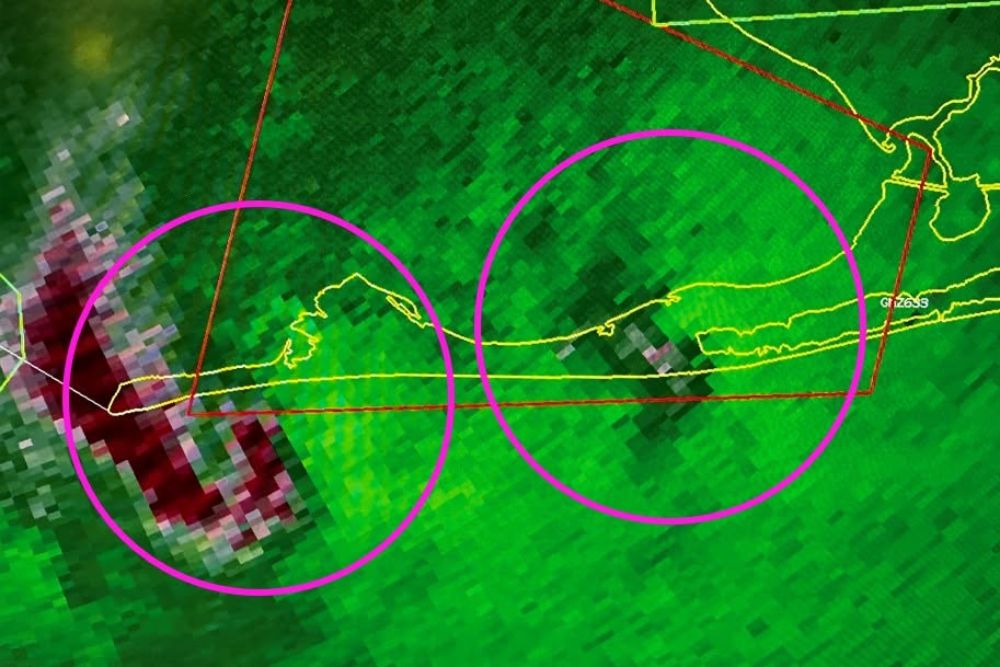
Fort Morgan, Alabama – A tornado warning issued for Fort Morgan in coastal Baldwin County was allowed to expire at 4:30 p.m. CT on Sunday and was not extended. Radar indicated that two waterspouts may have moved onshore along the Fort Morgan Peninsula, but so far there have been no reports of damage. The situation was made much more challenging by an ongoing radar communication outage affecting the National Weather Service radar in Mobile.
Two Possible Waterspouts Near Fort Morgan
Radar images showed two areas of interest near the Fort Morgan Peninsula, the narrow strip of land that stretches west from Gulf Shores toward the mouth of Mobile Bay. One area was located near the western end of the peninsula, close to the entrance of Mobile Bay, while the second was farther east along the coast.
It is possible that both waterspouts moved onshore, which is why a tornado warning was issued for the area. When a waterspout moves from water onto land, it is treated as a tornado, since it can cause damage to homes, trees, and power lines.
No Damage Reports So Far
The good news is that, so far, no damage has been reported from the possible waterspouts. Fort Morgan is home to beach houses, condos, and the historic Fort Morgan State Historic Site, so any reports of damage would be important to confirm. Officials and residents will continue to watch for any signs of damage now that the storms have moved through.
Not Visible From Gulf Shores Camera
A weather camera located in Gulf Shores was monitoring the area during the warning, but the waterspouts could not be seen from that view. The camera showed gray, overcast skies, rain, and low clouds hanging over the beach and coastline, which likely made it difficult to spot any waterspouts in the distance.
Conditions at the time in Gulf Shores included a temperature of about 77 degrees, with northeast winds around 6 mph.
Radar Outage Makes the Situation Challenging
The warning came in the middle of a rare radar communication outage affecting several radars along the Gulf Coast, including the KMOB radar in Mobile. While the radar itself was working normally, and the National Weather Service office in Mobile could still see the data, the information was not reaching the public, weather apps, or local media.
That made it extremely challenging for TV meteorologists and other weather outlets to show viewers where the storms were located or how they were moving. Without access to the local radar, broadcasters had limited ways to explain the threat to people along the coast.
NWS Sharing Radar Images Directly With Media
To help bridge the gap, the National Weather Service in Mobile began sharing radar images directly with media partners through a private online workgroup. This allowed local meteorologists to see the radar images that forecasters were using to issue warnings, even though the data was not available through normal channels.
The workaround helped keep information flowing during the event, but it is far from the usual setup, where radar data is available in real time to anyone with a weather app.
What Caused the Radar Problem?
The outage began with a fiber optic cable cut, which disrupted the connection used to send radar data from several Gulf Coast sites to the national network. A network card was later replaced, but the problem continued. Along with Mobile, the outage has affected radars at Fort Novosel in southeast Alabama, Eglin Air Force Base and Tallahassee in Florida, and Moody Air Force Base in south Georgia.
As of Sunday, there was no estimated time for when public access to the radar data would be restored.
Waterspouts Along the Gulf Coast
Waterspouts are fairly common along the Gulf Coast, especially when moisture is high and showers and storms develop over the warm waters of the Gulf. Some waterspouts form from ordinary showers and are usually weaker, while others develop from stronger thunderstorms and can be more dangerous.
When waterspouts move onshore, they can cause damage similar to a weak tornado, including downed trees, damaged roofs, and flying debris.
Stay Weather Aware
With an active weather pattern continuing across the Southeast and the radar outage still unresolved, residents along the Alabama and Florida Gulf Coast should make sure they have multiple ways to receive warnings. That includes Wireless Emergency Alerts on phones, NOAA Weather Radio, and local TV and radio. Even without public radar images, warnings are still being issued by the National Weather Service.
Anyone who sees a waterspout or experiences damage should report it to local authorities or the National Weather Service when it is safe to do so.
For more Alabama Gulf Coast weather updates and severe weather alerts, stay with bchssreport.com.