Arizona’s Mogollon Rim Faces Rare 100-Year Rainfall Today With 3 to 5 Inches Possible as Southwest Colorado Braces for Repeat Flash Flooding and a Possible High Risk Upgrade
PHOENIX, ARIZONA — Parts of the Southwest could see rainfall totals today, Sunday, November 1, 2026, that typically happen only about once every 100 years.
3 to 5 inches of rain is expected along the Mogollon Rim, north and east of Phoenix, and with ground already soaked, nearly all of that water is expected to run off. In southwest Colorado, the San Juan Mountains are facing what could be a repeat of last week’s flash flooding.
Outlook Updated Early Sunday Morning
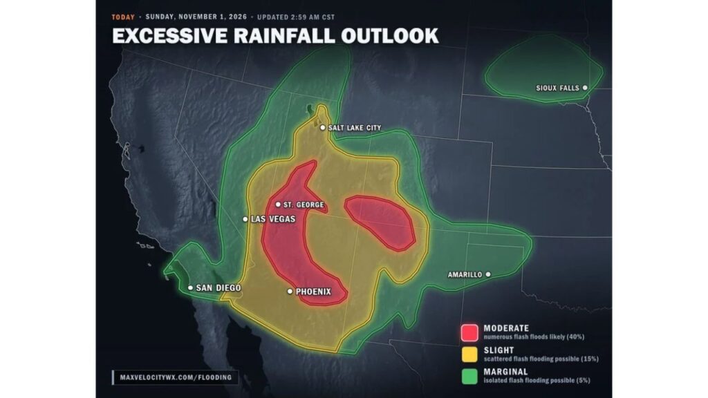
The excessive rainfall outlook for today was updated at 2:59 a.m. CST and keeps two Moderate Risk zones in place, with forecasters warning that an upgrade to a High Risk, the highest level, is possible.
| Risk Level | What It Means |
|---|---|
| High | Widespread, severe flash flooding (possible upgrade) |
| Moderate | Numerous flash floods likely, about 40% chance |
| Slight | Scattered flash flooding possible, about 15% chance |
| Marginal | Isolated flash flooding possible, about 5% chance |
Once-in-100-Years Rainfall Along the Mogollon Rim
The Mogollon Rim, a steep escarpment running across central Arizona north and east of Phoenix, is at the center of today’s heaviest rain. Totals of 3 to 5 inches could produce rainfall that only occurs about once a century in this area.
Moderate Risk Arc From St. George to Phoenix
The first Moderate Risk zone forms a long arc stretching from near St. George, Utah, south through western and central Arizona to the Phoenix area. Numerous flash floods are likely in this zone.
San Juan Mountains Face Another Round of Flash Flooding
The second Moderate Risk zone covers southwest Colorado and nearby southeast Utah, centered on the San Juan Mountains.
Forecasters say this area is looking at essentially a repeat of the flash flooding seen last week, raising concern for communities and roads still recovering.
Possible Upgrade to a High Risk
Because of the extreme rainfall potential, forecasters say an upgrade to a High Risk is possible. High Risk days are rare and usually signal widespread, life-threatening flooding.
Slight Risk Covers Salt Lake City, Las Vegas and Most of Arizona
A broad Slight Risk area surrounds the moderate zones, including:
- Salt Lake City and much of Utah
- Las Vegas and southern Nevada
- Most of Arizona
- Southwest Colorado and northwest New Mexico
Marginal Risk Reaches San Diego, Amarillo and the Northern Plains
An outer Marginal Risk extends to:
- San Diego and southeast California deserts
- Parts of Nevada, Idaho and western Colorado
- Eastern New Mexico and the Texas Panhandle near Amarillo
- A separate area in the northern Plains near Sioux Falls
Why Runoff Will Be So Dangerous
With ground already saturated from recent rain, most of today’s rainfall will not soak in. Instead, it will rush into washes, canyons, creeks and streets, causing water levels to rise fast.
Flash Flood Safety Today
- Stay out of washes, slot canyons and low spots
- Never drive into flooded roads, especially after dark
- Avoid burn scars in Utah and Colorado
- Move to higher ground immediately if water rises
- Keep phone alerts on for flash flood warnings
Outlook: Dangerous Flood Day Across the Southwest
Today is expected to be a high-impact flood day across Arizona, Utah and southwest Colorado. Residents should follow local alerts closely and be ready to act quickly.
Stay with Bchssreport.com for the latest updates on this story.
About The Author
