Eastern Florida From Jacksonville to Miami Under Level 2 Flood Risk Sunday and Monday as Lingering Heavy Rain Could Bring Several Inches Statewide
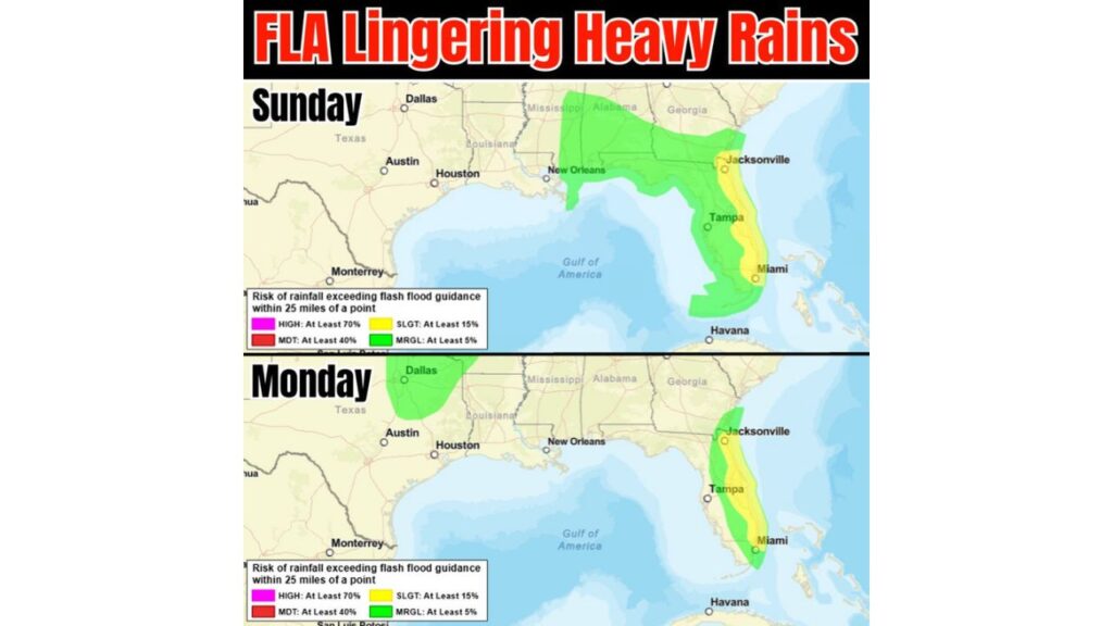
JACKSONVILLE, FLORIDA — Flood concerns are rising across eastern Florida, where excessive rainfall outlooks have been raised for Sunday and Monday, November 1 and 2, 2026. A Level 2 of 4 (Slight) risk for flash flooding now covers much of the Atlantic coast, from Jacksonville to Miami.
Lingering heavy rain is expected across most of eastern Florida, with widespread areas showing several inches of rain. Heavy rain is even possible on the west side of the state.
What the Flood Risk Levels Mean
| Risk Level | Chance of Flash-Flood-Producing Rain Within 25 Miles |
|---|---|
| High (Level 4) | At least 70% |
| Moderate (Level 3) | At least 40% |
| Slight (Level 2) | At least 15% |
| Marginal (Level 1) | At least 5% |
Sunday: Level 2 Risk Along Florida’s Entire East Coast
On Sunday, November 1, the Slight Risk covers a long strip of eastern Florida, stretching from Jacksonville south along the Atlantic coast to the Miami area.
Sunday: Level 1 Risk Covers the Rest of Florida and the Gulf Coast
A wider Marginal Risk on Sunday covers:
- Nearly the entire Florida Peninsula, including Tampa
- The Florida Panhandle
- Southern Georgia and Alabama
- Southern Mississippi
- Southeast Louisiana, including the New Orleans area
Monday: Level 2 Risk Continues From Jacksonville to Miami
The threat lingers into Monday, November 2. The Slight Risk remains over eastern Florida, again stretching from near Jacksonville down toward Miami.
Monday: Level 1 Risk Focuses on the East Half of the Peninsula
On Monday, the Marginal Risk narrows to mainly the eastern half of the Florida Peninsula, including the area near Tampa on its western edge.
A separate Marginal Risk also appears over north Texas, including the Dallas area.
Why Eastern Florida Is at Greater Risk
The heavy rain is tied to an upper-level low expected to stall over Florida, along with a front and converging winds near the coast. That setup can cause rain bands to repeat over the same areas, letting totals pile up quickly.
Several Inches of Rain Possible
Forecast guidance shows widespread areas picking up several inches of rain, with some spots possibly seeing 3 to 4 inches or more, especially near the east-central coast and around Tampa Bay.
Possible Flooding Impacts
With repeated rounds of heavy rain, residents could see:
- Street flooding in coastal cities and low-lying neighborhoods
- Flooded parking lots and underpasses
- Slow travel on I-95, I-4 and other busy roads
- Standing water that lingers in poorly drained areas
Flood Safety Tips for Florida Residents
- Never drive through flooded roads, even in familiar areas
- Avoid walking in floodwater, which can hide hazards
- Clear storm drains near your home if safe to do so
- Keep weather alerts on for flood advisories and warnings
- Allow extra time for travel on Sunday and Monday
Outlook: Heavy Rain Threat Through Monday
The flood threat is expected to continue through Monday before improving later in the week. Residents across eastern Florida should stay alert and follow local forecasts closely.
Stay with Bchssreport.com for the latest updates on this story.
About The Author
