North-Central Florida, Georgia and the Carolinas Could Face Severe Storms Thursday, November 5, as One Forecast Shows a Stronger, Slower Storm System Across the South
SOUTHEAST — Forecasters are watching Thursday, November 5, 2026, as a big storm system moves across the southern United States late next week. Computer models are still bouncing around on how it will develop, but one recent forecast run shows a stronger, slower system with a more favorable setup for severe storms stretching from north-central Florida up into the Carolinas.
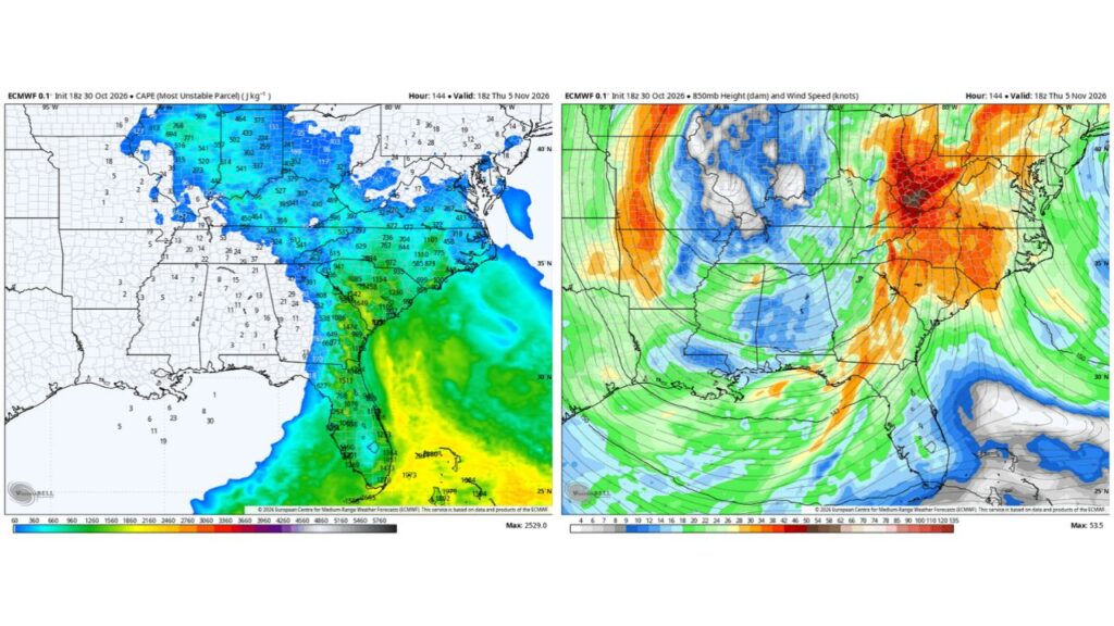
Forecast Snapshot: Thursday Afternoon, November 5
The forecast maps highlight conditions at about 1 p.m. EST Thursday, November 5, showing where instability and strong low-level winds could overlap, two key ingredients for severe storms.
Instability Builds From Florida Into Georgia and the Carolinas
Forecast instability values, which measure how much energy is available for storms, show a band stretching up the East Coast:
| Area | Forecast Instability (J/kg) |
|---|---|
| Central and South Florida | About 1,000 to 1,973 |
| North-Central Florida | About 1,000 to 1,500 |
| Eastern Georgia | About 1,000 to 1,650 |
| South Carolina | About 600 to 1,100 |
| North Carolina | About 400 to 1,000 |
| Virginia and the Ohio Valley | About 300 to 700 |
West of this band, Alabama, Mississippi and Louisiana show very little instability, placing the main storm energy along and east of Georgia.
Strong Low-Level Winds Over the Ohio Valley and Carolinas
Forecast winds about 5,000 feet above the ground show a powerful low-level jet setting up on Thursday:
| Area | Forecast Wind Speed |
|---|---|
| Ohio Valley, Kentucky and West Virginia | About 40 to 53 knots |
| Carolinas and Virginia | About 30 to 40 knots |
| Georgia | About 28 to 38 knots |
| North Florida | About 26 to 32 knots |
Strong winds this close to the ground can help storms rotate and produce damaging gusts.
Why This Setup Could Support Severe Storms
When instability and strong low-level winds overlap, storms can become organized and more dangerous. In this forecast, that overlap shows up across:
- North-central Florida
- Eastern Georgia
- South Carolina
- North Carolina
Models Still Disagree on How the Storm Will Evolve
Forecasters stress that this is only one scenario. Other model runs show different timing and strength. A faster or weaker system could lower the severe risk, while a slower, stronger storm, like the one shown here, could raise it.
Possible Hazards If the Setup Holds
If storms develop as this forecast suggests, potential hazards could include:
- Damaging wind gusts
- Isolated tornadoes
- Heavy downpours and localized flooding
- Frequent lightning
Part of a Busy Early-November Weather Pattern
This system follows a stretch of active weather across the South, including severe storms in the Plains on Monday, damaging wind threats in the lower Mississippi Valley on Tuesday, and a possible coastal storm developing off the Southeast late in the week.
What Residents Should Do Now
- Monitor forecast updates through the weekend and early next week
- Review severe weather plans for home and work
- Make sure emergency alerts are turned on
- Plan ahead for possible travel disruptions on Thursday
Outlook: Something to Keep an Eye On
With models still shifting, forecasters say this is something to watch closely. Residents from Florida to the Carolinas should stay tuned for updates as Thursday approaches.
Stay with Bchssreport.com for the latest updates on this story.
About The Author
