Kansas and Oklahoma Severe Storm Risk Grows for Monday, November 2, as Strong Low Over the Dakotas Drags a Cold Front Through the Plains
TOPEKA, KANSAS — The risk for strong to severe thunderstorms is becoming increasingly likely across parts of Kansas and Oklahoma on Monday, November 2, 2026, as a powerful storm system takes shape over the northern and central Plains.
Storm Setup at Noon Monday
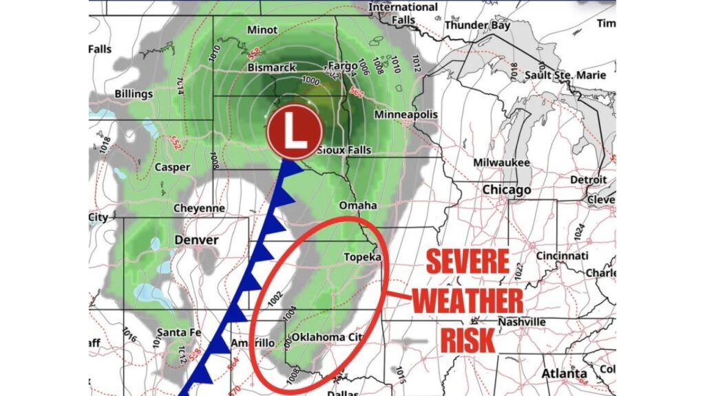
Ensemble forecast guidance for 12 p.m. CT Monday shows how the system is expected to look as storms begin to organize:
| Feature | Location at Noon CT Monday |
|---|---|
| Low pressure center | Central South Dakota, northwest of Sioux Falls |
| Central pressure area | Near 1,000 millibars |
| Cold front | From the low south through western Nebraska, eastern Colorado and the Texas Panhandle near Amarillo |
| Severe weather risk zone | Eastern Kansas and Oklahoma |
Strong Low Spins Over the Dakotas
The center of the storm sits over South Dakota, with tightly packed pressure lines wrapping around it. That kind of setup often brings strong winds and widespread precipitation across the northern Plains.
Rain and showers spread across North Dakota, South Dakota, Minnesota and Nebraska, reaching cities like Bismarck, Fargo, Minneapolis, Sioux Falls and Omaha.
Cold Front Stretches From Nebraska to the Texas Panhandle
A cold front extends south from the low through western Nebraska, eastern Colorado near Denver, and down into the Texas Panhandle near Amarillo.
Ahead of this front, warm and humid air is expected to surge north, setting the stage for storms later in the day.
Severe Weather Risk Zone: Topeka to Oklahoma City
The highlighted severe weather risk area covers:
- Eastern and central Kansas, including the Topeka area
- Central and northern Oklahoma, including Oklahoma City
- A small part of north Texas near the Red River
Within this zone, bands of rain and storms are already shown developing ahead of the front by midday.
Possible Hazards With Monday’s Storms
Based on the broader forecast for this system, Monday’s storms could bring:
- Damaging wind gusts, the main expected threat
- A few tornadoes, especially with early rotating storms
- Large hail in the strongest cells
- Heavy rain and frequent lightning
Storms Expected to Peak Monday Evening
While some showers may develop earlier, forecasters expect storms to fire and strengthen into the evening hours, with the highest tornado risk between about 6 p.m. and midnight in Oklahoma and nearby areas.
Areas Outside the Severe Threat
Cities farther east, such as Chicago, Milwaukee, Detroit, Cincinnati, Nashville and Atlanta, are outside Monday’s severe risk zone at this time. Areas west of the front, including Denver and Cheyenne, will see cooler air move in behind it.
Precipitation Also Spreads Into the Rockies
Light precipitation is shown over parts of Montana, Wyoming, Colorado and northern New Mexico, including areas near Billings, Casper, Cheyenne and Santa Fe, as the system pulls in moisture.
How to Prepare for Monday’s Storms
- Review your severe weather plan and know where to shelter
- Turn on phone alerts and keep a weather radio handy
- Secure loose outdoor items before winds pick up
- Plan evening travel carefully across Kansas and Oklahoma
- Charge devices in case of power outages
Outlook: Severe Threat Shifts East Tuesday
After Monday, the storm system is expected to push east, bringing a damaging wind risk to East Texas, Arkansas, Louisiana and Mississippi on Tuesday.
Stay with Bchssreport.com for the latest updates on this story.
About The Author
